India & Natural Disaster Management
Re: India & Natural Disaster Management
murugan, that info is flawed.. 18th century was not adi shankara days. anyway, it would interesting to know the architecture of the temple.
Re: India & Natural Disaster Management
Murugan, Some info on dimensions of temple, other things are irrelevant.
Re: India & Natural Disaster Management
Well yes. The 18th century should be 8th century. looks like a extra '1' added by mistake. Also "Slav" is slab.
-
Bade
- BRF Oldie
- Posts: 7212
- Joined: 23 May 2002 11:31
- Location: badenberg in US administered part of America
Re: India & Natural Disaster Management
Adding to comments on participation of local institutions, the avenues of funding they can pursue do not have to be limited to government related like DST in case of India. In the west "crowd sourcing" if I got the term right, is being used where private money from small time contributions being used to pursue lines of research not supported by govt agencies or other peer reviewed sources where competition is stiff and players well established.
Locals can pool in and target a particular host institute to establish such centers. Once the word gets out, more voluntary contributions can be sourced. But all this will need the institute to look at alternate sources. From what I can gather, IIT Mandi has the right spirits for such approaches and might even encourage if some seed investor comes forward. From their brochure they seem most welcome to new ideas.
Locals can pool in and target a particular host institute to establish such centers. Once the word gets out, more voluntary contributions can be sourced. But all this will need the institute to look at alternate sources. From what I can gather, IIT Mandi has the right spirits for such approaches and might even encourage if some seed investor comes forward. From their brochure they seem most welcome to new ideas.
Re: India & Natural Disaster Management
Some good news;
Mass Cremation underway, Rescue Halted due to bad weather
UttaraKhand floods a man made disaster. Not natural
I think root cause analysis is being made without all the facts. The IMD said it was heavy rainfall over many days where as cloud burst is just a sudden occurence.
Mass Cremation underway, Rescue Halted due to bad weather
andAmid fears of epidemic outbreak, the mass cremation process in Kedarnath, worst-hit in the Uttarakhand flash floods, was expedited, even as air operations to evacuate stranded people from Badrinath was today halted with the weather packing up.
"A total of 18 bodies have been cremated so far in Kedarnath. The next round of cremation will start only after formalities like identification, DNA sample preservation, post mortem of the bodies are completed," DIG Sanjay Gunjyal, under whose supervision the exercise is taking place, told PTI.
A second team of doctors, forensic experts and police personnel has left for Kedarnath to complete the formalities, he said.
The rescue operations and the mass cremation process have been affected because of bad weather, the DIG said, adding that the formalities for the cremation of the victims were also taking time. The cremation exercise had resumed yesterday after it was suspended because of inclement weather.
The Health Department has warned people in adjoining areas not to consume river water as it may be highly polluted. With the air thick with foul smell of decaying bodies in the area adjoining the Kedarnath shrine, the department has expressed apprehensions about spread of various infectious diseases.
"We are now quickly cremating the bodies which have been recovered. But given the scale and nature of the tragedy, there is a likelihood that many bodies could still be lying in open spots, where rescue personnel have not been able to find or reach them," Ravikanth Raman, nodal officer of rescue operations in Guptkashi, said.
Meanwhile, 208 people have so far been evacuated from the Harsil sector but 600 more are still stranded.
"We were able to pull out 1,341 people from various sectors. From Badrinath, which is a key focus area, we could only pull out 350 because the weather gave an hour's opportunity, and we made use of that. The Harsil operation is likely to finish today," Air Commodore Rajesh Issar said in Dehradun.
As many as 14 choppers were being kept ready to fly to Badrinath to evacuate pilgrims, another IAF officer said. "The moment the weather clears up, we will resume the operations for Badrinath Dham," he said.
With more than 3,000 people still stranded in Harsil and Badrinath, rescue operations were going on amid intermittent rains, which were affecting evacuation efforts at places including Dehradun and Chamoli district, where Badrinath shrine is located, official sources said.
According to official figures, so far 822 people have lost their lives in the Uttarakhand disaster. The figure includes over 260 bodies found in Kedarnath area.
Officials said relief material was also being flown in more than 40 choppers for distribution in villages where shortage of foodgrains has been reported.
There have been reports of people facing shortage of foodgrains, electricity and water in affected villages, adding to the problems of authorities, which are still grappling with the evacuation exercise.
A report from Rishikesh said angry kin of people from Rajasthan, who went missing after the calamity, burnt a banner put up by the state government at its relief camp near the bus stand in the city and clashed with media personnel.
They were protesting against absence of information about their missing relatives from the officials deputed for the purpose.
Rescue operations were hampered at Sahastradhara helipad in Dehradun this morning due to rains, but resumed as the weather cleared up later, with three choppers flying to the affected areas.
Brigadier Uma Maheshwari said the two hubs, where people were waiting to be evacuated were Badrinath and the Harsil-Gangotri axis.
"If the helicopter evacuation continues, Harsil operation will be completed by the afternoon. That is, provided, the weather permits the choppers to fly," the officer said.
Maheshwari said 500 people had left Badrinath by foot and they were on route to Joshimath, and about 220 had crossed to Gobind Ghat, while the Hemkund axis was all clear.
"The total distance from Badrinath to Joshimath is 43 kilometres, and out of this distance, the pilgrims have to walk only for 12 kilometres. For the rest of the distance, they will be moved by vehicles," the officer said, adding that the Army was giving confidence and motivation to the people to undertake the land route.
Maheshwari said Army and civil aviation choppers had evacuated more than 100 people from isolated places in Uttarakhand since this morning.
UttaraKhand floods a man made disaster. Not natural
I think root cause analysis is being made without all the facts. The IMD said it was heavy rainfall over many days where as cloud burst is just a sudden occurence.
However not to say that the babucracy was tardy in installing what was already approved 6-7 years ago.On 14th June, the Indian meteorological department predicted heavy to very heavy rainfall in the hilly regions of Uttarakhand in during next 48-96 hours. But they miserably failed at sounding a timely alert indicating the magnitude of the massive disaster.
While nature may not always be predictable, Indian administrative machinery is. Governments may change, Babus get promoted, but the people continue to pay for their follies.
This radar could have saved thousands as a dark storm brewed over the hills of Uttarakhand. Had it not been caught in red tape, the Doppler radar could have sent out timely warnings and thousands could have been evacuated in time.
Under modernization of the IMD, 55 Doppler radars were approved by Government of India way back in 2007-08. The IMD was to furnish an estimated price which would then go to the Ministry of Earth Sciences, which in turn sends it to Planning Commission for approval. But in these six years, the file is shuttling between three departments, moving at a snail's pace and net result is zero.
Dr. Chandan Ghosh, Head of the Geo Hazards, National Institute of Disaster Management said, "Uttarakhand govt had placed request of Doppler radar (which can forecast cloud burst when attached to supercomputer) with Centre but the same couldn't be installed due to bureaucratic hurdles."
It is a surprise that in the first phase of installation of these radars, Uttarakhand got the miss. Seventeen radars were installed at various locations but none in Uttarakhand. Isn't this utter neglect on the part of the Centre?
"The defaulter is our leadership at the state and centre. It is these men who are to blame.. for each person dead in the Uttarakhand tragedy. For years ministers and babus simply looked the other way as experts urgently clamoured for deployment of weather radars," said Satish Bhatia, Scientist F, Upper Air Instruments Division.
"Tragedy could have been avoided if weather radars had existed at local level. Tragedy highlights need for sensors at local/state level to detect micro-climate and forecast phenomena such as cloudbursts. Overall satellite picture doesn't give specific data required to forecast such disasters," Avinash Chander, DRDO chief.
Despite being prone to frequent cloudbursts, flashfloods and landslides, Uttarakhand has virtually no system in place for early warnings, weather forecasts or even dissemination of rainfall and landslide related data. What is worse, despite the assurances, it may take over an year before the system is deployed in the misery struck hills.
Re: India & Natural Disaster Management
I think for certain logical things, we don't need any fishbone or root cause analysis. For example:
- declare places of natural interest, zones as national/international (for funds only) reserves
- no mining/industries, except for infrastructure constructions that should take nature into prime considerations
- zero emission industries may be permitted but not at the protected zones.
- strict policies on constructions, place of worship, places that needs extra care where people congregate.
Re: India & Natural Disaster Management
Interview with a priest who was at Kedarnath when it happened.
Heavy rain started Sunday/Sunday night. He mentions Chorbari taal failiing
(taal phat gaya) on Monday morning at 6:55 a.m. (at about 1:00 minute into the video).
If the taal indeed failed, it should be easy enough to confirm that once things settle down.
[youtube]tzAA7anRMYY&NR[/youtube]
He fell into the flood and survived! Army then rescued him. (Interviewer comes across as blase/callous ...'actual story kya hai',
the poor guy lost relatives and some are yet untraced). Priest estimates that 5 to 6 thousand are dead in Kedarnath
alone (around 2:00 in the video).
PS: There's another youtube video of an interview with a purohit at Kedarnath. interviewed
at some airport (Dehradun?). He too estimates several thousand dead in Kedarnath alone.
Re: India & Natural Disaster Management
Bade, the hi-lighted disciplines can only do things downstream (no pun intended) which is the easier third of the equation. Civil works plus atmospheric sciences have to take the lead in that the latter would specify locations to monitor and the former would have to construct the physical on the ground infra.Bade wrote:The local institutions which have related expertise say from civil engg for hydrology related studies, geology dept and sciences (CS, math, physics) and the atmospheric sciences ...
...
These kind of activities are usually the bread and butter of applied research in US universities that feed in and support local communities making their presence in the neighborhood more relevant.
I say it is the easier third from a WAG that the amount of data to be collected and processed is not going to be that great - even a $30K system (16 cores, 1 TB RAM, 12 TB disk, SSD) can do the number crunching. Can you give estimates of amount of data? Thanks.
-
Bade
- BRF Oldie
- Posts: 7212
- Joined: 23 May 2002 11:31
- Location: badenberg in US administered part of America
Re: India & Natural Disaster Management
Big institutes have a lot of computing power like at IITM, in Pune or IISc, in Blur. Again, it depends on what the end goal is. Some of the medium range forecast models and cyclone tracking expertise exist even at IIT-Delhi. Such skill sets will be needed or students trained. Computing aspects are perhaps the easiest to solve if a steady stream of CS/Math/Phys students are available. Roorkee also must have experts in hydrology and geology.
If you are asking about satellite data volumes it is not much for the localized region of interest, not more than a few hundred gigabytes each day. Lots of models are developed elsewhere, so initially it will be just putting it together to make it all run. Less research. I am talking straight as I type with not too much of a deep thought or understanding of all that will be needed. But the best way to setup is to collaborate with another univ who has done similar things before one starts out independently to speed up the process.
Setting up field stations to collect data and monitoring them as part of a larger network, is something the Himalayan institutes can take advantage of.
Re: India & Natural Disaster Management
if we are going to build weather models, would like to see few models that can be used to create similar conditions in a wind tunnel used for testing rotary aircraft, there are one too many accidents involving choppers in that weather and terrain. Even a C-130 could be used for data collection purposes.
Re: India & Natural Disaster Management
http://timesofindia.indiatimes.com/indi ... 811342.cms
Good work by Armed forces. Salute to our Jawans who risked their life to save as many as possible.DEHRADUN: With the weather improving, the rescue operations in Uttarakhand on Friday picked up pace, with 17 choppers being flown to evacuate people still stranded at various locations.
Mass cremation of bodies in Kedarnath, the worst-affected in flood fury, was on, as authorities were racing against time to minimize risks of epidemic outbreak.
As the sun shone bright this morning, helicopters took off to rescue an estimated 1,237 people now stuck at different places in the hill state, with the Harshil sector totally cleared of pilgrims. About 3,000 people are still reported missing, officials said.
The focus now is on Badrinath Dham area, where majority of the pilgrims are now stranded, they said.
All major roads except the Joshimath-Badrinath, Rudraprayag-Gaurikund and Uttarkashi-Gangotri routes have been reopened, raising hopes of speedy evacuation, they said.
Army chief Gen Bikram Singh arrived this morning at Gauchar to review ongoing relief operations and pay tribute to the 20 soldiers killed in a chopper crash near Gaurikund on Tuesday.
Union home minister Sushilkumar Shinde is also scheduled to arrive in Dehradun to honour the bravehearts who laid down their lives during the rescue operations.
An official estimate said approximately 1,237 persons are now stranded at different places across the state. Till now 1,04,687 persons have been evacuated from different places by road and air.
Re: India & Natural Disaster Management
Something more on ecology and architecture
http://www.navhindtimes.in/opinion/why- ... ved-floods
***
http://www.navhindtimes.in/opinion/why- ... ved-floods
***
Re: India & Natural Disaster Management
^courtesy navhindtimes, that is an excellent article to be thrown up with full listing here for discussions.
I am giving *****
I am giving *****
BY NANDKUMAR M KAMAT
SEVERAL years ago, Goa’s leading Gandhian NGO, the Peaceful Society, Madkai had invited two stalwarts of the environmental movement and vanguards of famous ‘Chipko’ movement in Uttarakhand to Goa at different times to interact with people.
While listening to lectures of Dr Chandiprasad Bhat and Sunderlal Bahuguna we learnt the importance of conservation of forests and hill slopes and eco-sensitive watersheds.
Both the environmentalists did everything to stop deforestation in sub-Himalayan region. They were carrying their message to Goa – do not convert unstable hill slopes into concrete jungles, do not destroy the watersheds of the rivers, protect the forests covering the hill slopes and conserve the trees everywhere. Their predictions have now proved correct. But it is too late for India and Indians to learn any lessons.
Challenge of climate change
India would survive the challenge of climate change only if traditional wisdom is combined with ecological sensitivity and appropriate, locally suitable modern technology in architecture and civil engineering. The evidence comes from miraculous survival of a manmade structure – the Kedarnath temple.
Surrounded by mud, dead bodies and debris- the temple stands as a symbol, a tribute to India’s traditional architectural and civil engineering wisdom. The temple is contemporaneous with the Mahadev temple at Tamdi Surla built by Goa Kadamba queen Kamaladevi Permadi.
The design and architectural principles used in construction of both Tamdi Surla temple and Kedarnath temple are similar. From choice of location to erection of platform and building material- the elements of maintenance and durability were built in the design principles.
Heavy polished stone slabs were welded to slabs without any mortar and ‘man-woman’ type joints were used to integrate the superstructure. The Archaeological Survey of India has damaged the “L” shaped interlocking drainage channels of the rooftop monolithic slabs of Tamdi Surla temple in the name of restoration activity.
Kedarnath temple survived the force of floods because of a strong stone plinth specifically built in the steep valley area to withstand the vagaries of the climate. Global climate change has finally shown what it can do to India’s ancient locations of pilgrimage. The destruction by landslides and mudflow took a heavy toll on modern buildings, many built illegally without any concern for local environment but the thousand years old Kedarnath temple survived.
The survival of Kedarnath temple also showed that India would need new ideas in architecture which should stand up to the challenges of changing weather and severe natural calamities. These floods would remind Goans of floods faced by Canacona flash floods of October 2009. It was illegal mining, quarrying, deforestation due to slash burning (kumeri), landslides and siltation in the channel which had caused heavy mudflow in Canacona.
The five centuries Vaishnavaite monastery of Partagal on the banks of Talpona river had narrowly escaped permanent damage. On June 17, 2013 Uttarakhand received more than 340 centimeters of rainfall. This was 375 per cent more than the benchmark of 6.6 centimeters rainfall during a normal monsoon. This caused heavy floods in Himachal Pradesh, Uttarakhand and Western Nepal.
Dehra Dun, capital of Uttarakhand, experiences its wettest June day for over five decades. Heavy rainfall for four consecutive days as well as melting of the snow aggravated the floods. Landslides, caused due to the floods, damaged several houses and structures, killing those who were trapped.
Fury of floods
Many villages and settlements such as Gaurikund and the market town of Ram Bada, a transition point to Kedarnath, faced the fury of the floods. The market town of Sonprayag (Guptprayag) suffered heavy damage and loss of lives. Kedarnath is a popular shaktipeethha – an important temple for Saivaite pilgrimage circuit. It is one of the holiest Hindu temples dedicated to the Lord Shiva located on the Garhwal Himalayan range near the Mandakini river in Kedarnath.
The extreme weather conditions make the temple accessible only between the end of April to November. To reach the temple, pilgrims have to trek 14 kilometres uphill from Gaurikund. The temple is also one of the four major sites in India’s Chota Char Dham pilgrimage of Northern Himalayas. Though the Kedarnath temple itself has not been damaged, its base was inundated with water, mud and boulders from the landslide causing damage to its perimeters.
Many hotels around the temple were destroyed, resulting in a lot of casualties. Most of the destruction at Kedarnath was caused by the sudden rapid melting of ice and snow on the Kedarnath mountain, six kilometres from the temple, which flooded the Charbari lake and then Kedarnath. The rains in sub-Himalayan part of India actually arrive in July. But this year they struck the higher catchments in June with full fury. Kedarnath temple is located in a very deep gorge, surrounded by very steep mountain slopes. The Google Earth terrain images of the location would take one’s breath away. It is a very different, very difficult hilly, steep terrain. Hindu Lord Shiva or Mahadev is lord of annihilation. But it was the Hindu god of rain – Lord Indra who seemed to have shown the fury in Kedarnath. The temple could save lives of some pilgrims but the stampede also resulted in killing of many others.
This whole episode has raised several questions for the central and state governments about our national and local capacitance against climate change. Are our architects and engineers well tuned to build structures which would stand for centuries and be resistant to climate change? The Rege Commission report on collapse of old Mandovi bridge blamed it on corrosion of cables in concrete deck slabs. Even today quality parameters for water used for curing the RCC have not been notified. People are spending huge amounts in Goa for weatherproofing, waterproofing and corrosion control. The survival of Kedarnath temple offers us some hope. If the temple is so resilient then it is not because of any divine force because that force would not have seen death of thousands of innocent pilgrims. The temple as a manmade structure has sent a national message- there is no substitute to ancient Indian architectural wisdom if we were to survive the future calamities.
Re: India & Natural Disaster Management
ETV UP/UK @ETVUPLIVE
सेना के एक जवान ने किया खुलास केदारनाथ से रामबाड़ा तक 2 हजार शव, आईटीबीपी जवानों ने दी जानकारी, भयावह मंजर को देख सामान्य नहीं हो पाए जवान
सेना के एक जवान ने किया खुलास केदारनाथ से रामबाड़ा तक 2 हजार शव, आईटीबीपी जवानों ने दी जानकारी, भयावह मंजर को देख सामान्य नहीं हो पाए जवान
Re: India & Natural Disaster Management
Bharatiya Sena ADGPI FB Update
The Chief of the Army Staff, General Bikram Singh today visited the flood affected state of Uttarakhand to laud to the efforts of soldiers and junior leaders who saved the lives of fellow countrymen while risking their own lives. Interacting with the soldiers on ground, the Army Chief appreciated their valiant efforts to search, locate, establish contact and then conduct rescue, relief and evacuation operations on an unprecedented scale.
Interacting later with the journalists at Gaucher, the Army Chief said that large number of soldiers hail from Uttarakhand and their own families have suffered. Unmindful of their personal concerns, the soldiers took active part in relief and rescue operations. In fact, some even refused to take leave and get back to their home to attend to their kith and kin.
The Army Chief further added that our troops have exhibited commitment unparalleled in history. He complimented Officers, Junior Commissioned Officers and Jawans for a job well done and gave them a pat for their efforts. Commenting on the people still left, the COAS said that there are less than 500 at Harsil and upto 3000 at Badrinath.
Without setting exact timeline for completion of operation as it is dependent on weather conditions, the Army Chief went onto say that all efforts are underway to evacuate all at the earliest. As far as Badrinath is concerned, he said that the road is open.
The Army constructed a class 3 bridge over Alaknanda River. People have walked and in fact the Army Commander himself walked over it. People can also move by road. He said that all people have been evacuated from Kedarnath.
Replying to a question about the role of the Army in helping the state administration to rehabilitate and rebuild, the Army Chief reiterated that the Army is in aid to civil authorities. Army is there to strengthen the hands of the civil administration. Army is in their support. It was a very difficult operation but the valiant efforts of soldiers on ground resulted in saving lives.
Meanwhile, evacuation continued from Badrinath and Harsil today. 452 people were evacuated by air form Harsil today. Till the reports came in, 99 people have been evacuated by air from Barinath, 682 have already reached Joshimath by foot and 750 are now on their way by foot and are likely to reach Joshimath tonight. Army continued to provide shelter, food, medical aid, blankets and counselling to hundreds of people on the twelfth consecutive day of operations.
Re: India & Natural Disaster Management
SC asks Uttarakhand to airlift people, not make them walk
NEW DELHI: The Supreme Court on Friday asked the Uttarakhand government not to force people caught in flash floods to walk long distances and said that they should instead be airlifted to safer places.
"The state government should not force people to walk long distances," a bench of justices AK Patnaik and Ranjan Gogoi said.
The state government assured the apex court that rescue operations will be over by tomorrow. It said at present 1,000 pilgrims are in Badrinath in a safe condition and there is no shortage of water, food materials there.
The bench, after going through the report of the state government, posted the case for hearing on July 3.
The bench was hearing a PIL filed by lawyer Ajay Bansal, who has sought the apex court's directions to the Centre and state government to rescue people stranded in the flood hit areas in Uttarakhand.
-
Bade
- BRF Oldie
- Posts: 7212
- Joined: 23 May 2002 11:31
- Location: badenberg in US administered part of America
Re: India & Natural Disaster Management
Dave Petley from Durham Univ. has updated his blog with newly released pictures from RISAT-1 by ISRO.
http://blogs.agu.org/landslideblog/2013 ... now-clear/
I recall one of the eye-witness accounts mention two channels of flow from right and left sides of the temple in the NDTV interview. Satellite data reinforces that.
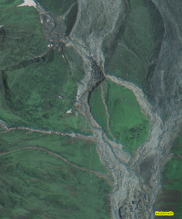
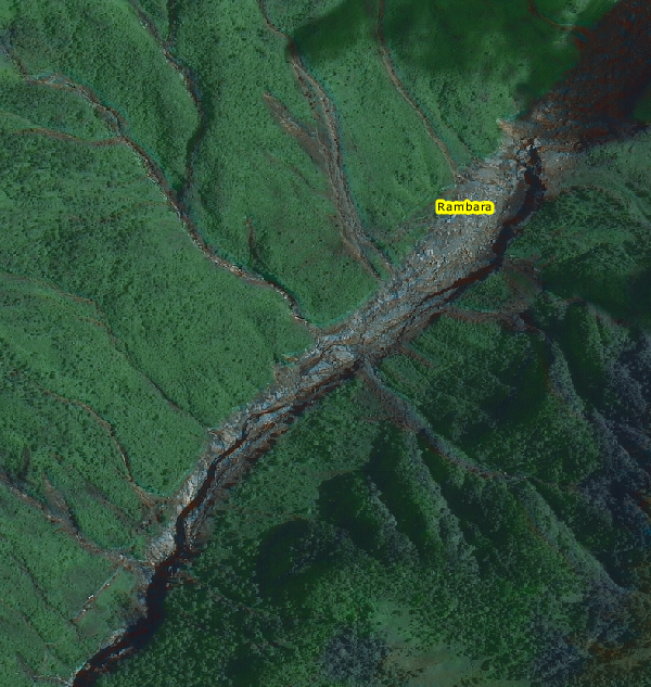
Look at the roads disappeared with the landslides downstream where an entire village has been destroyed by the flow.
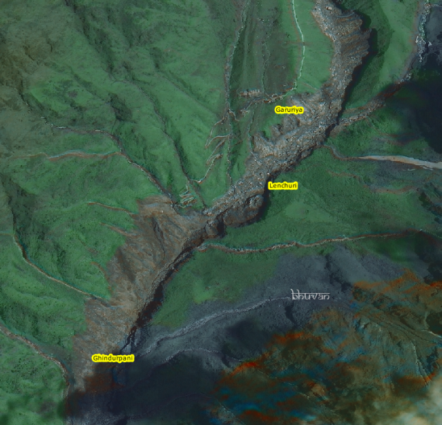
You can even see the roads appear again briefly well south if Rambara following the destruction path. There are also shorter road blockages due to minor flows from the western fronts seen in the picture.
http://blogs.agu.org/landslideblog/2013 ... now-clear/
I recall one of the eye-witness accounts mention two channels of flow from right and left sides of the temple in the NDTV interview. Satellite data reinforces that.
Look at the roads disappeared with the landslides downstream where an entire village has been destroyed by the flow.
You can even see the roads appear again briefly well south if Rambara following the destruction path. There are also shorter road blockages due to minor flows from the western fronts seen in the picture.
Re: India & Natural Disaster Management
Wait a minute. The Army Brig Maheshwari had said people have to walk the 11 km where it is impossible to truck and then they get transported all the way. Why is SC tang in this rescue effort?
They could not direct foreign websites to not hand over private details to US but can interefere in rescue efforts?
Nor could they direct the Govt to take action to protect the rights of the citizen but can issue direction here?
---
Bade, how come ISO is not releasing these pictures of their own accord. Its not like RIASAT is tied to NASA or anything like that?
S^3 Whats the scoop?
-
Bade
- BRF Oldie
- Posts: 7212
- Joined: 23 May 2002 11:31
- Location: badenberg in US administered part of America
Re: India & Natural Disaster Management
ISRO released these via Bhuvan their GIS toolkit. Srikumar had posted the links a few pages above.
Petley has put the story together as far as possible with just images. Good job on his part. Will have to wait for a few months before everyone can agree on what happened. The scale of the flow is captured well by RISAT-1 for sure.
Petley has put the story together as far as possible with just images. Good job on his part. Will have to wait for a few months before everyone can agree on what happened. The scale of the flow is captured well by RISAT-1 for sure.
-
Bade
- BRF Oldie
- Posts: 7212
- Joined: 23 May 2002 11:31
- Location: badenberg in US administered part of America
Re: India & Natural Disaster Management
Here is the ISRO release of images with a before and after toggle feature.
http://bhuvan-noeda.nrsc.gov.in/projects/flood/
http://bhuvan-noeda.nrsc.gov.in/projects/flood/
Re: India & Natural Disaster Management
ramana wrote:Wait a minute. The Army Brig Maheshwari had said people have to walk the 11 km where it is impossible to truck and then they get transported all the way. Why is SC tang in this rescue effort?
They could not direct foreign websites to not hand over private details to US but can interefere in rescue efforts?
Nor could they direct the Govt to take action to protect the rights of the citizen but can issue direction here?
---
Bade, how come ISO is not releasing these pictures of their own accord. Its not like RIASAT is tied to NASA or anything like that?
S^3 Whats the scoop?
They think Rescue is done by diktat and ill prepared UK Govt would run a 100M race like Usain Bolt if order is given. It presumes capability.
They also know those foreign websites /Unkil gives two hoots to their farting and centre has zilch capability to enforce it either.
Hence , saved themselves the embarrassment.
-
Theo_Fidel
Re: India & Natural Disaster Management
bade saar, for you..
http://www.thehindubusinessline.com/new ... 806285.ece
Andaman tsunami warning system can alert in 3 min: Scientist
http://www.thehindubusinessline.com/new ... 806285.ece
Andaman tsunami warning system can alert in 3 min: Scientist
-
Bade
- BRF Oldie
- Posts: 7212
- Joined: 23 May 2002 11:31
- Location: badenberg in US administered part of America
Re: India & Natural Disaster Management
^^^ Have they installed signage where to evacuate to in case of a warning everywhere near the coastal areas ?
I am told by my local panchayat rep that they have some kind of evacuation drill in place. They used it once post the 2004 tsunami event in our neck of the woods for fishermen folks living next to the coast. Last I visited the beach areas close to home (~2km) I did not see any signage though they have developed the beach front into a mini Venice beach with shades and tiled areas and car parking for beach goers.
I am told by my local panchayat rep that they have some kind of evacuation drill in place. They used it once post the 2004 tsunami event in our neck of the woods for fishermen folks living next to the coast. Last I visited the beach areas close to home (~2km) I did not see any signage though they have developed the beach front into a mini Venice beach with shades and tiled areas and car parking for beach goers.
-
Theo_Fidel
Re: India & Natural Disaster Management
Those images are wonderful and fascinating even if tragic.
Petley's logic is powerful and convincing.
A natural morraine feature acted as a temporary dam. When it failed it concentrated the debris flow towards the town. This concentrated flow over topped the natural protective, Morraine barrier north of Kedarnath. This meant the flow was now focused on the town rather than around it. The delay also meant that the NE flow was able to catch up, so both struck town simultaneous. Sheer bad luck.
The town had been doomed for a long time, just did not know it.... ...speaks for the need of better GIS mapping and modeling...
What is also clear is that most of the dead must be UK folks even though the focus has not yet shifted to them.
Re: India & Natural Disaster Management
Uttarakhand assembly speaker says toll may cross 10,000
The whole focus had been on Kedarnath Circuit and I think that was only tip of the iceberg. More than 200 Villages have been destroyed and no help reached them till date. The wide area was affected and now with lack of supplies of essential commodities and medicene , doctors etc may resylt id deaths of those who are surviving till now.
Below is a statement from Speaker of UK Assembly.
The Govt report has dark pointers to the tragedy unfolding.
ALMORA/GWALIOR: The number of people killed in cloudbursts and flash floods in Uttarakhand recently may cross 10,000 mark, state assembly speaker Govind Singh Kunjwal said on Saturday.
"Earlier when I returned from a tour of Garhwal region I believed the casualty figure could be 4000 to 5000. But now as per my information and bodies being seen by the people, I can say the figure can cross the 10,000 mark," Kunjwal told told reporters here.
Though refusing to quantify casualties even 14 days after the tragedy, chief minister Vijay Bahuguna has been saying it is feared over 1,000 people might have been killed in the natural calamity.
According to him, the exact number of people killed will be known only after the removal of debris.
Kunjwal said arrangements should be made immediately by the government to dispose of the bodies in view of the threat of an epidemic.
Re: India & Natural Disaster Management
Tsunami drill is well established now. Locals know where to evacuate and there are shelters constrcuted . Warning Systems are well established and fishermen folk are sensitized about it. Having seen the destructuion they are more understanding now. But laxity does creep in if drills are not conducted. Shelters, may of them which I have seen are not in good keep. The problem is we need to really empower local governance as depending on Babus may not work.Bade wrote:^^^ Have they installed signage where to evacuate to in case of a warning everywhere near the coastal areas ?
I am told by my local panchayat rep that they have some kind of evacuation drill in place. They used it once post the 2004 tsunami event in our neck of the woods for fishermen folks living next to the coast. Last I visited the beach areas close to home (~2km) I did not see any signage though they have developed the beach front into a mini Venice beach with shades and tiled areas and car parking for beach goers.
Re: India & Natural Disaster Management
Bade garu, that analysis seems to be fine. There was indeed twice that Flash flood came. One was in the midnight coming from NE side and followed at about 6-7 Am from NW side which caused even more damage as folks who survived were already tired and not suspecting further flooding and had taken shelter in temple. compound which was about 6-8 feet high. These are from eyewitness account on TV that I was watching. I think west channel was almost closed for a very long time since the construction of check dam on chorabari lake. Still no confirmation if lake burst. But from those images it seems exccessive rain caused bursting of temp dam or topping.
But anyway , the disaster was in the making and Kedarnath was threatened for quite sometime, only there was no research or report on this or if there was any , it was buried deep. Theo garu is bang on the spot about the threat.
But anyway , the disaster was in the making and Kedarnath was threatened for quite sometime, only there was no research or report on this or if there was any , it was buried deep. Theo garu is bang on the spot about the threat.
Re: India & Natural Disaster Management
Incidentally, He is the same fellow who was maintaining Daves lanslide Blog and had extensive writings on Hunza Landslide.
http://www.landslideblog.org/
http://www.landslideblog.org/
Re: India & Natural Disaster Management
http://www.openthemagazine.com/article/ ... a-disaster
Snippet
Snippet
As instructions were passed on from the civil administration, officers coordinating the Army work reacted with disgust in private. They had already been mortified by the interruption caused to the relief work by the VIP visits which have continued despite Union Home Minister Sushil Kumar Shinde issuing an alert: “We advise all VIPs not to visit Uttarakhand now...such visits hamper their work.’’ It is another matter that two days before issuing the alert Shinde toured the flood-hit areas and a 24-seater MI 17 helicopter along with a civilian helicopter was diverted for the whole day.
-
Theo_Fidel
Re: India & Natural Disaster Management
chaanakya,
despite early reports it seems clear this was chorbari lake that failed. There is no sign of it in the latest GIS image.

In this image of Chorbari, you can see the edge of the glacier moraine directly across from the lake. Though you can't see it the glacier is directly in front of you. The failure took place at the wall to the right, further down the water, so that entire bowl must have filled with water, which then flooded the town.
despite early reports it seems clear this was chorbari lake that failed. There is no sign of it in the latest GIS image.
In this image of Chorbari, you can see the edge of the glacier moraine directly across from the lake. Though you can't see it the glacier is directly in front of you. The failure took place at the wall to the right, further down the water, so that entire bowl must have filled with water, which then flooded the town.
Re: India & Natural Disaster Management
we need to identify similar lakes, and surroundings. get a digital map and analyze week points for future flash floods
-
abhishek_sharma
- BRF Oldie
- Posts: 9664
- Joined: 19 Nov 2009 03:27

Re: India & Natural Disaster Management
Govt sat on Met warning and did not put off Yatra
Put off yatra, evacuate pilgrims, Met said, but govt sat on warning
Jun 30, 2013, 02.19AM IST TNN[ Pankaj Doval ]
Army soldiers use a stretcher to carry an elderly pilgrim from an IAF helicopter at Joshimath on June 29, 2013, after he was evacuated from Badrinath in Uttarakhand. (AFP photo)
DEHRADUN: A series of advisories sent out by the Met department on June 14, 15 and 16 to various authorities in Uttarakhand warned not only of "very heavy rains" but also urged that people be "moved to safer places" and that the Char Dham yatra be "postponed". These advisories, accessed exclusively by TOI, provide the most damning evidence that the devastation in Uttarakhand could have been averted and thousands of lives saved had the warnings been heeded.
The warnings had been sent to a slew of top officials, including the state's chief secretary, the district magistrates (of the districts where the Char Dham yatra takes place), the Disaster Management and Mitigation Centre, ITBP, OSD to the Char Dham yatra and other top authorities. Tragically, none realized the gravity of these warnings or acted on them.
The warning, issued by the state meteorological department, was not picked up in right earnest even by its own headquarter, the India Meteorological Department (IMD), which could perhaps have alerted the Centre and the state government on the impending danger.
The first of the warnings of "heavy rain" was issued on June 14 in the agro-advisory bulletin. The executive director of the Disaster Management and Mitigation Centre had also been warned of "heavy rains" on the same day. On June 15 - a full day before the catastrophic rains, floods and landslides devastated the state - the weather report predicted "heavy rain during the next 72 hours". This was issued to the DM of Rudraprayag as well as the ITBP. More crucially, the advisory with this report said, "yatris (pilgrims) are requested to get back to safer places".
If this was not enough, a special advisory related to the Char Dham yatra was also issued by the Met department on June 15 which had specifically predicted "heavy to very heavy rains" for June 16 and June 17 and had clearly mentioned the danger: "Warning - Char Dham yatris are advised to postpone yatra by four days."
This advisory was for the Badrinath, Kedarnath, Gangotri, Yamnotri and Joshimath regions — all of which suffered majorly in the subsequent landslides and rains which became violent on the night of June 16.
With not much response and the weather conditions looking increasingly perilous, the state's met department again issued an advisory to various authorities on June 16, shortly before noon, many hours before the destruction, which started towards late evening. The weather report for the Kedarnath and Badrinath regions once again had an advisory, "yatris to get back to safer places. Heavy rains likely during the next 36 hours." The district magistrate of Rudraprayag and the state's chief secretary were also alerted.
When contacted, Anand Kumar Sharma, director of Uttarakhand's meteorological department, confirmed that specific warnings and alerts had been issued along with the weather report. "Yes, I had issued timely and correct weather forecast for heavy to very heavy rains and landslides for June 16 and June 17, with an advisory that people should not venture into the hills and those already there should be moved to safer places." Sharma also confirmed that he had advised that the yatra be postponed in view of the extremely bad weather.
Very heavy rains rare
The state's chief secretary Subhash Kumar, however, sought to play down the warnings, "These (alerts) happen every year, forecasting heavy rains. They say this every year, but do not point out the intensity," he said. Sharma disagrees. He says that the word "very heavy rains" is not a routine warning and is given only in extreme conditions. "This is issued during one of the rarest of rare instances," he emphasized.
Ironically, the chief secretary's casual response to the Met warnings runs contrary to his own praise of Sharma's work and the state's met department very recently.
The lax behavior of the top officials as well as authorities is already under scrutiny and the state's governor is understood to have asked for a report on the matter.
-
Bade
- BRF Oldie
- Posts: 7212
- Joined: 23 May 2002 11:31
- Location: badenberg in US administered part of America
Re: India & Natural Disaster Management
A SOP should exist on the grounds what these various advisories mean and what action to take. Looks like there was none in the works from the above reports on statements by two people in charge.
Yes, it is true it helps to put a number to "very heavy rains" in this day and age. Why not have 5 level warnings or color codes even and each should trigger some action on part of authorities. In any case it is doubtful with even a 3-day lead warning, they had some mechanism in place to evacuate people. It would have saved more lives even if the response before the event was tardy on part of state machinery. What were the local TV stations doing if not highlighting the weather forecast in their regular programming. This would be the best possible way to reach the masses even by word of mouth.
Yes, it is true it helps to put a number to "very heavy rains" in this day and age. Why not have 5 level warnings or color codes even and each should trigger some action on part of authorities. In any case it is doubtful with even a 3-day lead warning, they had some mechanism in place to evacuate people. It would have saved more lives even if the response before the event was tardy on part of state machinery. What were the local TV stations doing if not highlighting the weather forecast in their regular programming. This would be the best possible way to reach the masses even by word of mouth.
Re: India & Natural Disaster Management
What is the warning system in place?
- sirens
- sms
- audio devices
- announcements
- radio
- tv
- color coded (like bade said)
- other alerts
do we have recorded evidences to support gov claims?
and what was the reach of such communications? did it reach everyone on yatra?
- sirens
- sms
- audio devices
- announcements
- radio
- tv
- color coded (like bade said)
- other alerts
do we have recorded evidences to support gov claims?
and what was the reach of such communications? did it reach everyone on yatra?
Re: India & Natural Disaster Management
Chorabari Lake is empty now. The failure point is clearly visible in the images posted in the blog and here by Bade and the force of water eroded the western side of the hill directly in the path and seems to have created two channels, one west and other in the centre. This seems to have happened after the first deluge took place from eastern side.Theo_Fidel wrote:chaanakya,
despite early reports it seems clear this was chorbari lake that failed. There is no sign of it in the latest GIS image.
In this image of Chorbari, you can see the edge of the glacier moraine directly across from the lake. Though you can't see it the glacier is directly in front of you. The failure took place at the wall to the right, further down the water, so that entire bowl must have filled with water, which then flooded the town.
Actually I am impressed by Dr Dave's Analysis. He is director of the Institute of Hazaard, Risk and Resilience at Durham University in the United Kingdom and perhaps UK Govt could send few Engineers to Study at his institute to build analysis capability in environment hazard.
Re: India & Natural Disaster Management
These images shows the damages to the area. Compare Pre and Post images . It becomes clear that West channel caused more damage. I could see that huge rock behind the shrine. It might have come with first deluge or at the beginning of second one.
http://bhuvan.nrsc.gov.in/updates/galle ... ory=damage
http://bhuvan.nrsc.gov.in/updates/galle ... ory=damage
Re: India & Natural Disaster Management
From recent news dated June 6th 2013, its a matter of modeling the dynamicsSaiK wrote:we need to identify similar lakes, and surroundings. get a digital map and analyze week points for future flash floods
4,699 high altitude lakes in Himalayas mapped
Re: India & Natural Disaster Management
Chorabari tal m just overlooking the shrine area, watch the last frame
This one is even better
Shows the town from the lake , I suspect that could be the point where videographer was standing. Also notice the amount of loose boulders. If lake was filled it had no other way to go but to Kedar.
And this video shows manmade structure at the Lake
This one is even better
Shows the town from the lake , I suspect that could be the point where videographer was standing. Also notice the amount of loose boulders. If lake was filled it had no other way to go but to Kedar.
And this video shows manmade structure at the Lake
Re: India & Natural Disaster Management
shiver me timbers boys, but has anyone taken a look at badrinath in google earth?
the village seems in path of two potential avalanches, one directly on top from the east and one at an angle from the south.
also if you proceed up the river, the photos shows the river almost totally blocked by a huge landslide from the east.
does not look to be a safe state imo.
the village seems in path of two potential avalanches, one directly on top from the east and one at an angle from the south.
also if you proceed up the river, the photos shows the river almost totally blocked by a huge landslide from the east.
does not look to be a safe state imo.