UAVs, Drones, Remote Surveillance Tech
Re: UAVs, Drones, Remote Surveillance Tech
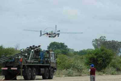
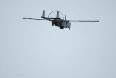
There is wheeled Nishant project and is being publically displayed for last 3 years in various def expos
Re: UAVs, Drones, Remote Surveillance Tech
Meanwhile in Hollywood...
Tony Scott to fly Top Gun sequel in an unmanned direction
Tony Scott to fly Top Gun sequel in an unmanned direction
Tony Scott has confirmed he will direct a sequel to his 1986 blockbuster Top Gun. The film, he told the Hitfix blog, could focus on a new era of aerial warfare in which pilots control unmanned planes remotely.
Scott said the film would also be about the end of the era of fighter pilots. He said: "These guys are still test pilots and they manned the drones when they were first running them."
Re: UAVs, Drones, Remote Surveillance Tech
Information on Snake Robot developed by Technion Lab in Israel.
http://defense-update.com/wp/20101110_s ... _brml.html
http://defense-update.com/wp/20101110_s ... _brml.html
Researchers at the BioRobotics and BioMechanics Labortory (BRML) or Israel Technion are working on an improved, more robust and agile snake robot that will enhance the performance already demonstrated by an earlier BRML ‘robotic snake’ in 2009. Unlike the previous robot, that used a centralized processor to control the individual elements, the new model employs independent links built as common elements, each packing the logic and control processors, inertial sensors, servo actuators, power source, communications and sensors. The new robot will soon enter testing at the lab, and will eventually be tested by the Israel Defense Forces, as part of the Defense Research & Development Directorate’s urban terrain robotics program.
According to Lt Col. Gabi Dobresco, head of UGV and Advanced Concepts Branch at the Land Systems Division, DDR&D, the IDF is evaluating the snake robot as part of biologically-motivated structures dealing with challenging scenarios.
According to Dobresco, the robotic snake could be useful in urban and subterranean warfare, enabling the inspection and surveillance of sewage systems, narrow tunnels, or culverts, inaccessible by other systems. Another advantage of such robots is the fact that the entire robot acts as highly flexible arm having multiple Degrees Of Freedom (DOF).
The vision for snake robots, outlined by Dobresco includes highly maneuverable snake shaped robot that can maneuver through difficult terrain, ‘sneak’ stealthily inside buildings, use its sensors to scan their interiors. The robot will be able to carry disposable sensors that could be separated and left behind to monitor activity inside buildings. When suspicious activity inside buildings is detected, the stealthy robot will be able to identify specific targets while remain virtually unnoticed, and leave behind delayed activated explosive charges for employing lethal effect.
As primary sensors, the robot will be equipped with a thermal imager, miniature cameras or low-light TV sensors, and possibly laser scanners operating as laser radar (LADAR). As each of the links is embedded with cameras, the entire group provides redundant, instant multiple 360 degree view of the surrounding while mapping of indoor and subterranean areas by laser radar.
The new snake developed at BRML represents a major step in the DDR&D direction. Unlike the previous snake having a single DOF for each link, requiring 16 links to form sufficient flexibility and maneuverability, each of the new robot links has two joints, providing 2 DOF per link, hence, the number of links per ‘snake robot’ can be reduced to eight. The motors embedded in the new design have significantly higher moment /weight ratio. Each link is equipped with its own inertial system, reporting its relative position (to other elements), enabling the automatic motion and maneuver control to determine the position of the entire robot, and determine the next move to bring the robot closer to its objective, through difficult terrain and along the movement path selected for movement.
This 7kg prototype uses elements made of aluminum to meet the level of ruggedness required for field operation. However, for a production models Technion researchers expect the weight to drop by half, below four kg, as much of the aluminum parts with durable composite materials.
BRML displayed the new robot today at the Israeli Conference on Robotics (ICR) held today in Herzelia.
The video below depicts he first generation snake robot developed at the Technion lab.
Re: UAVs, Drones, Remote Surveillance Tech
Laser powered UAV(pelican quadrocopter) flies untethered for more than 12 hours setting new records.
http://www.defensenews.com/story.php?i= ... =FEA&s=TEC
http://www.youtube.com/watch?v=8hhv9Cu98us
http://www.defensenews.com/story.php?i= ... =FEA&s=TEC
Check out the video as wellThink of it as the ultimate red-eye flight: A tiny helicopter flew overnight powered by an infrared laser beam.
By the time the Pelican quadrocopter landed - 12 hours, 26 minutes and 56.9 seconds after takeoff - it had set a number of records, including longest hovering flight for an untethered electric aircraft and longest flight using beamed energy.
And the 2-pound, four-rotor aircraft didn't have to land.
"It could have flown indefinitely," said Tom Nugent, president of LaserMotive, the Seattle company that conducted the Oct. 28 flight.
The idea of flying on laser power "has been science fiction for a long time - now, it's for real," Nugent said.
The chief advantage laser power offers is enabling UAVs to fly much longer than is now possible. The longest flight by a conventional fuel-powered UAV is 80 hours, achieved by Boeing's giant Condor.
For electric UAVs, the unofficial record goes to QinetiQ's Zephyr, which used solar power and batteries to fly for 14 days.
Nugent says he can do better. With laser power, it is possible to produce a high-performance UAV that essentially never needs to land.
Power for the UAV would come from a laser beam that is generated on the ground and focused on the UAV, where special photovoltaic cells tuned to the laser's wavelength and intensity convert the laser light into electricity to drive the UAV and charge an onboard battery.
The process is called "power beaming," and that's how the quadrocopter flew, hovering at an altitude of about 30 feet inside a hangar that houses the Future of Flight Aviation Center north of Seattle.
Using the same laser technology, the company powered a robotic climber that zipped up a 3,280-foot cable dangling from a petroleum-powered helicopter. That accomplishment won LaserMotive $900,000 in NASA's 2009 power-beaming challenge.
The half-day quadrocopter flight was "quite an accomplishment," said Charles Reinholtz, chairman of the mechanical engineering department at Embry-Riddle Aeronautical University. It suggests that there might be "lots of interesting niche operations" for laser-powered UAVs that can stay aloft for prolonged periods.
Nugent sketches out several roles for laser-powered UAVs.
The simplest would be as stationary observation platforms. In that role, UAVs would fly up to a useful altitude and stay there, providing surveillance with video cameras and other sensors. They would be kept aloft by power supplied through a laser beam on the ground.
"A permanently stationed high-altitude UAV would behave in many ways like a low-cost, high-performance geostationary satellite, except that it would be located only a few miles above the ground," LaserMotive says in a paper promoting laser power for UAVs.
Another operating concept would permit the UAVs to embark on distant missions by flying on batteries recharged in the air by laser beams.
UAVs could fly 100 miles or more to conduct surveillance, loitering over targets and sending back sensor data until its batteries are low. Then, the UAV flies to a laser-beaming station, where it circles to recharge its batteries. One beaming station could keep multiple UAVs charged and flying, LaserMotive says.
Conversely, a UAV might fly from one beaming station to another to conduct operations over a wide area. And a "daisy chain" of laser beaming stations might be used to power electric UAVs that patrol U.S. borders, Nugent said.
In a third operating scenario, UAVs would be continuously linked to a laser beam on the ground and patrol a relatively small area, such as the perimeter of a military base. Or a laser mounted on a vehicle could power a UAV that flies ahead of a convoy, searching for roadside bombs and conducting surveillance, LaserMotive says.
Laser-powered UAVs are not particularly efficient. About 60 percent of the electricity pumped into the laser turns into laser light. A bit of that energy is then lost in the atmosphere as it travels to the UAV. Once there, about 50 percent of the laser light that strikes the photovoltaic cells on the UAV is converted back into electricity to power the UAV.
From start to finish, the process is about 25 percent efficient, Nugent said. That means 4,000 watts of electricity going into the laser will yield 1,000 watts of electricity on the UAV.
By way of comparison, internal combustion engines are about 20 percent efficient; some fuel cells have efficiency rates more than twice that.
While beaming power to a UAV via laser light can theoretically keep the aircraft flying indefinitely, whether it actually does may depend on the weather.
"Horrible snow or dense fog" will keep the laser light from reaching the UAV, Nugent said, and light rain might restrict the laser's range.
LaserMotive says laser-powered UAVs will reduce military logistics requirements by reducing the number of people needed to land, refuel and relaunch UAVs. But the lasers will need a steady supply of electricity to keep the UAVs flying, so personnel will be needed to operate generators and maintain other power sources that keep the lasers shining.
The lasers will not burn people or set things on fire, but they do pose a hazard to eyes, Nugent said. LaserMotive is developing a safety system that would turn the lasers off if anything - birds or a piloted aircraft, for example - enters a zone around the laser-powered UAV. During the time the laser is off, the UAVs would fly on battery power.
LaserMotive is hoping UAVs are just the first step into a wider market for beaming power via lasers.
Power generated by one satellite could be beamed to others. Instead of stringing wires, power could be beamed to remote locations such as forward operating bases and remote communications towers. Power could be beamed to cameras, sensors and other appliances, LaserMotive says.
"We see a lot of possible markets," Nugent said. "We're using UAVs as stepping stones to different markets."
NASA scientists, who used a laser to beam power to much lighter fixed-wing UAVs in 2003, had similar visions.
They said power beaming might be used to supply electricity to high-altitude airships and even satellites, as well as military UAVs. The space agency also said laser light beamed from satellites might power robotic rovers on the moon and Mars, and space-based "solar farms" might one day beam power to the Earth, the moon and other planets.
http://www.youtube.com/watch?v=8hhv9Cu98us
Re: UAVs, Drones, Remote Surveillance Tech
X-Posted from "International military Discussion"thread.
Must read.Assasination technology being developed by Americans.Pentagon is rapidly mastering Manhunting technologies and skills.
http://www.popsci.com/technology/articl ... re-anytime#
Must read.Assasination technology being developed by Americans.Pentagon is rapidly mastering Manhunting technologies and skills.
http://www.popsci.com/technology/articl ... re-anytime#
Not since the end of the Cold War has the Pentagon spent so much to develop and deploy secret weapons. But now military researchers have turned their attention from mass destruction to a far more precise challenge: finding, tracking, and killing individuals.Every year, tens of billions of Pentagon dollars go missing. The money vanishes not because of fraud, waste or abuse, but because U.S. military planners have appropriated it to secretly develop advanced weapons and fund clandestine operations. Next year, this so-called black budget will be even larger than it was in the Cold War days of1987, when the leading black-budget watchdog, the Center for Strategic and Budgetary Assessments (CSBA), began gathering reliable estimates. The current total is staggering: $58 billion—enough to pay for two complete Manhattan Projects.
Where does the money go? Tracking the black budget has always been a challenge. Constantly shifting project names that seem to be randomly generated by computers—Tractor Cage, Tractor Card, Tractor Dirt, Tractor Hike and Tractor Hip are all real examples—make linking dollar amounts to technologies impossible for outsiders. But there are clues.
According to Todd Harrison, an analyst at the CSBA, the allocations for classified operations in the 2011 federal budget include $19.4 billion for research and development across all four branches of the military (funding for the CIA, including its drone strikes in Afghanistan and Pakistan, is contained within the Defense Department black budget), another $16.9 billion for procurement, and $14.6 billion for “operations and maintenance.” This latter category, Harrison notes, has been expanding quickly. This may suggest that many classified technologies are now moving from the laboratory to the battlefield.
In fact, the rise in classified defense spending accompanies a fundamental change in American military strategy. After the attacks of September 11, the Pentagon began a shift away from its late Cold War–era “two-war strategy,” premised on maintaining the ability to conduct two major military operations simultaneously, and began to focus instead on irregular warfare against individuals and groups. That strategic shift most likely coincides with an investment shift, away from technology that enables large-scale, possibly nuclear, war against superpower states and toward technology that helps military planners hunt and kill individuals. Each branch of the military uses different language to describe this process. Pentagon officials have spoken openly about their desire to use advanced technology to “reduce sensor-to-shooter time” in situations involving “time-sensitive targets.” The head of U.S. Special Operations Command talks about “high-tech manhunting,” while Air Force officials describe plans to compress the “kill chain.”
Even inside the Pentagon, few people know the precise details of the black budget. But by combining what is known about Pentagon goals and what is known about the most recent advances in military technology, we can begin to sketch its general contours.
The first link in the kill chain: finding the person to hunt. Particularly in Afghanistan and Pakistan, this type of intelligence gathering is increasingly done using unmanned aerial vehicles (UAVs). According to the New America Foundation, a nonprofit think tank, the U.S. conducted 45 drone strikes in Pakistan in the first six months of this year. The centrality of unmanned aircraft to such missions suggests that the black budget is almost certainly already funding next-generation drones.
In April 2009, a French magazine published a photograph of one recent product of that funding—a slender-winged aircraft that had previously been spotted in southern Afghanistan and that aerospace experts had begun calling the Beast of Kandahar. After another photograph surfaced, this one a clear shot of the craft on the runway in Kandahar, the Air Force issued a statement that finally gave the Beast a formal identity: the RQ-170 Sentinel.
Manufactured by Lockheed Martin, the RQ-170 is a tailless flying wing with the telltale shape and surface contours of a stealth aircraft. Black-plane watchers immediately noticed similarities between the RQ-170 and Lockheed’s unmanned Polecat aircraft, which UAV observers had long speculated was being developed in secret and which was finally made public at the Farnborough International Airshow in England in 2006. The Air Force says that the Sentinel is a reconnaissance drone, a claim supported by the aircraft’s lack of visible armaments, by the sensors that appear to be embedded in its wings, and by its “RQ” designation.
But much about the RQ-170 is puzzling. Why would the Air Force need a stealth aircraft in Afghanistan, a country with no radar defense system? It wouldn’t, according to those familiar with the drone. The RQ-170 was developed with a more sophisticated enemy, perhaps China, in mind. That doesn’t mean it couldn’t be adapted for current conflicts, however. Unlike the relatively easy-to-spot Predator and Reaper drones, the RQ-170’s stealth could allow it to conduct missions that those aircraft cannot, such as clandestine tracking, or slipping unnoticed across Afghanistan’s border into Iran or Pakistan to spy on their nuclear programs.
Aircraft like the RQ-170, the Predator and the Reaper can get only so close to their targets, of course, which is why the Pentagon is developing micro-drones designed to investigate dangerous terrain undetected. In April the Washington Post reported that the CIA was using pizza-platter-size micro-drones to find insurgents in Pakistan. And the 2010 Pentagon budget contains a brief unclassified reference to Project Anubis, a micro-drone developed by the Air Force Research Laboratory. The Air Force won’t talk about that specific vehicle, but a more general 2008 marketing video released by the lab did suggest that future micro-UAVs might be equipped with “incapacitating chemicals, combustible payloads, or even explosives for precision targeting capability.” The video depicts an explosives-laden drone dive-bombing and killing a sniper. Budget documents indicate that Project Anubis (named for the ancient Egyptian god of the dead) is now complete, which means a lethal micro-drone could already be in the field.
The Pentagon is forging the next link in the kill chain—following an individual—with at least one high-priority research program. The Clandestine Tagging, Tracking and Locating initiative (abbreviated both as CTTL and TTL), which was conceived in 2003, is slated to get about $210 million in unclassified funding between 2008 and 2013 and may receive more than that from the black budget. “The global war on terrorism cannot be won without a Manhattan Project–like TTL program,” was how officials from the Defense Science Board, a civilian committee that advises the Pentagon, described the situation in a 2004 presentation, adding that “cost is not the issue.”
In a 2007 briefing, Doug Richardson, an official working in the Special Reconnaissance, Surveillance, and Exploitation program in Special Operations Command, said that the Pentagon wanted to use 14 different technologies for tagging and tracking targets such as people and vehicles. Tagging could involve marking targets with invisible biological paints or micromechanical sensors; tracking would mean monitoring those markers from a distance. Other schemes entailed capturing a person’s “thermal fingerprint” and then tracking him or her, perhaps from aircraft equipped with infrared sensors.More details can be found in proposals from companies and scientists seeking Pentagon contracts. One such proposal, from a University of Florida researcher, uses insect pheromones encoded with unique identifiers that could be tracked from miles away. Other plans employ biodegradable fluorescent “taggants” that can be scattered by UAVs. Voxtel, a private firm in Oregon, has already made available a product called NightMarks, a nanocrystal that can be seen through night-vision goggles and can be hidden in anything from glass cleaner to petroleum jelly.
Perhaps the most advanced tagging concept is “smart dust,” clouds of “motes,” tiny micro-electromechanical sensors that can attach themselves to people or vehicles. Thousands of these sensors would be scattered at a time to increase the chance of at least one of them reaching its target. Kris Pister, a professor at the University of California at Berkeley, was sponsored by the Defense Advanced Research Projects Agency (Darpa), the Pentagon’s R&D branch, more than a decade ago to work on smart dust and was able to create sensors the size of rice grains. In the beginning, he now says, he and his colleagues imagined “smart burrs” that could attach to a target’s clothing as he or she brushed by, or “smart fleas” that could jump onto their targets. Pister says that this kind of autonomous microsensor is probably still not feasible. In 2001, however, his group succeeded in scattering more-primitive smart-dust motes from a small aerial drone and using them to track vehicles. A single UAV could easily carry thousands of tags, he says.
Read it completely.It will give you an idea where the future warfare is headed.And most importantly these technologies might have been invented for irregular warfare but they can be used very effectively for regular warfare as wellAn alternative to the conventionally armed land-based ICBM is a hypersonic weapon, essentially a cruise missile capable of traveling at many times the speed of sound—faster than anything in today’s conventional arsenal. These missiles would not have to leave the Earth’s atmosphere and would have very different trajectories from ICBMs, so Russia would be less likely to mistake them for nuclear weapons.
The Pentagon has mentioned two non-ICBM candidates for Prompt Global Strike, one from the Army and one from Darpa. Both of these weapons would be boosted into the atmosphere by rockets and then glide back to Earth at hypersonic speeds. In addition to these official Prompt Global Strike options, the Pentagon is conducting at least three other hypersonic or near-hypersonic research efforts: the Air Force’s X-51 WaveRider, which used a scramjet engine to accelerate to Mach 6 in May; the Navy’s Revolutionary Approach to Time-Critical Long-Range Strike project, known as RATTLRS; and the Darpa-sponsored HyFly, a dual-combustion ramjet. (Ramjets and scramjets achieve rocket-like speeds without the heavy burden of liquid oxygen by mixing jet fuel with compressed air that enters the engine from the atmosphere.)
The proliferation of hypersonic research may mean that the Pentagon has faith in the technology. But it also makes black-budget watchers like John Pike, the director of the military information Web site GlobalSecurity.org, suspicious. Pike believes the military’s hypersonic programs may just be a cover for yet another black project. What kind, though, he has no idea.
Re: UAVs, Drones, Remote Surveillance Tech
From National Defense Magazine.
Army and Marines pursue Robotic convoy systems.
http://www.nationaldefensemagazine.org/ ... stems.aspx
http://www.nationaldefensemagazine.org/ ... obots.aspx
Army and Marines pursue Robotic convoy systems.
http://www.nationaldefensemagazine.org/ ... stems.aspx
Another Article regarding progress on unmanned ground systems.Because roadside bombs have claimed the lives of thousands of troops, both the Army and Marine Corps are pursuing efforts to reduce the number of injuries and deaths by developing robotic trucks that can drive long distances at highway speeds.
As part of its modernization plan, the Army is funding several ground robotics programs ranging from small, remotely controlled explosive ordnance disposal units to large autonomous tactical wheeled vehicles.
One of the more mature initiatives is a kit that promises to turn any of the Defense Department’s trucks into an autonomous system.
Funded by the Army Tank Automotive Research, Development and Engineering Center, the convoy active safety technology program aims to improve convoy operations. The kit is small enough to be installed in the cab of a transport vehicle while allowing ample room for soldiers to ride along. It connects to the steering wheel and pulls in feeds from the various sensors that are installed on the vehicle. The sensors include millimeter wave radar, LIDAR (light detection and ranging) and electro-optical and infrared cameras.
The system is configured to operate either in an optionally piloted mode where the soldier sits behind the wheel but the vehicle drives itself, or in a fully autonomous mode without any humans in the cab.
If an insurgent tries to disrupt the convoy by cutting into the line of vehicles, troops can simply hit a red button to disengage the autonomy in order to take control of the situation.
In an Army Research Laboratory experiment, soldiers operated the vehicles in trials that involved finding hidden improvised explosive devices, or IEDs. Soldiers ran the scenarios twice, once with troops driving, the second with CAST in operation.
“They saw 25 percent more IEDs when they were using CAST,” and at greater distances, said James Lowrie, director of autonomous systems at Lockheed Martin Corp. The soldiers also experienced no rear-end collisions, he told National Defense.
The price point for a full-production system is reportedly $20,000 per unit.
http://www.nationaldefensemagazine.org/ ... obots.aspx
Researchers at the Georgia Tech Research Institute used eBay as inspiration when they were searching for ways to make unmanned aerial and ground robots work autonomously to search for targets.
Using two small unmanned aircraft and an SUV that can drive itself, the three vehicles employ computer algorithms to conduct an auction over the airwaves. Once a human has designated an area for them to search, the onboard computers start bidding on which of the three is the closest and has the most fuel to spare. The winner takes off to conduct its search, leaving the other two to carry out other missions.
“We don’t want for a human operator to have to tell each vehicle what to do and where to go,” said Charles Pippin, a research scientist at the institute. “We prefer that the vehicles communicate with each other and task themselves.”
The 2009-2034 Unmanned Systems Integrated Roadmap produced by the office of the secretary of defense called for “autonomous adaptive tactical behavior” for ground robots. Researchers want to take the burden of tele-operating the machines off soldiers who have enough things to worry about in war zones. Or they want robots to do routine tasks such as carrying heavy loads or driving vehicles down highways with little or no directions from their human masters.
As Jim Overholt, senior research scientist of robotics at the Army Tank Automotive Research, Development and Engineering Center, put it, automation can “let a soldier be more situationally aware as he drives down an alley and let the mundane job of driving a vehicle be handled by the computer.”
Autonomy was a key theme at the 2nd annual Robotics Rodeo held here.
The Southwest Research Institute equipped a Ford Explorer with a computer system that can be switched to six different modes: manual driving; tele-operated; pedestrian following; vehicle following; supervised autonomy and full autonomy, said Ryan Lamm, manager of intelligent vehicle systems at the San Antonio, Texas-based nonprofit.
Within the vehicle following mode, the system can be set to follow at longer distances, or it can drive to the right or left of the lead vehicle. In some cases, it’s not always advantageous to follow another vehicle in a straight line, Lamm said.
“The more reliable comms you have, the more you are able to extend the distance out,” he said. The truck currently can follow a lead vehicle and self-drive up to 70 meters behind. If a pedestrian or other obstacle gets in the way, it either swerves or stops, then automatically goes faster to catch up with the convoy.
In the pedestrian-following, or dismounted, mode, the vehicle’s sensors are programmed to visually latch onto a person on foot and stay a few paces behind as he or she walks forward. Even if another pedestrian walks in within the truck’s line of sight, it remains zeroed in on the original subject.
The tele-operated mode allows a person to drive the vehicle remotely. A driver behind the wheel can choose to revert to manual mode and take complete control of the vehicle, or do “supervised autonomy” — making small adjustments to the steering, speed or brakes if he doesn’t like the choices the computer is making.
In a small system, iRobot Corp. has developed the AwareHead, a pedestrian-following, gesture-controlled software and sensor suite that it can integrate into its family of robots. The idea is to lessen the operational burden placed on soldiers, lighten their load and decrease time on task.
It’s not enough to just have a robot that can follow a soldier and carry equipment while avoiding obstacles. It must also sense situations, said Christopher Geyer, senior lead research scientist at iRobot of Bedford, Mass. For example, if it sees its leader firing a weapon, it can react by moving more conservatively.
“We are trying to make interaction with the robot more natural,” Geyer added.
For robots that are autonomously traversing over rough areas without a human guide, St. Paul, Minn.-based Primordial Inc. has adapted software that was designed to help soldiers find the best path from point A to point B.
Re: UAVs, Drones, Remote Surveillance Tech
Gorgon Stare Wide Area Airborne Surveillance System on MQ-9 reaper.
http://www.aviationweek.com/aw/jsp_incl ... dLine=null
http://www.aviationweek.com/aw/jsp_incl ... dLine=null
The U.S. Air Force’s new Gorgon Stare Wide Area Airborne Surveillance System, described as a revolutionary intelligence, surveillance and reconnaissance (ISR) technology, will make its combat debut in December, flying over undisclosed locations in Afghanistan on board MQ-9 Reaper unmanned aerial vehicles (UAVs).
Gorgon Stare was conceived, designed and developed in less than three years by prime contractor Sierra Nevada Corp. and USAF’s 645th Aeronautical Systems Group, a rapid acquisition arm also known as Big Safari. It offers an exponential expansion in the scope, amount, quality and distribution of video provided to ground troops, manned aircraft crews, ISR processing centers and others, then-Lt. Gen. David Deptula, Air Force deputy chief of staff for ISR, told DTI prior to his retirement on Sept. 30.
Gorgon Stare’s payload is contained in two pods slightly larger than, but about the same total weight as the two 500-lb. GBU-12 laser-guided bombs the Reaper carries. The pods attach to the inside weapon racks under the wing. One pod carries a sensor ball produced by subcontractor ITT Defense that protrudes from the pod’s bottom. The ball contains five electro-optical (EO) cameras for daytime and four infrared (IR) cameras for nighttime ISR, positioned at different angles for maximum ground coverage. The pod also houses a computer processor. The cameras shoot motion video at 2 frames/sec., as opposed to full motion video at 30 frames/sec. The five EO cameras each shoot two 16-megapixel frames/sec., which are stitched together by the computer to create an 80-megapixel image. The four IR cameras combined shoot the equivalent of two 32-megapixel frames/sec. The second Gorgon Stare pod contains a computer to process and store images, data-link modem, two pairs of Common Data Link and Tactical Common Data Link antennas, plus radio frequency equipment.
Gorgon Stare is operated independently but in coordination with the Reaper’s crew by a two-member team working from a dedicated ground station, which fits on the back of a Humvee. A second Humvee carries a generator and spare parts. A separate, forward-deployed processing, exploitation and dissemination team co-located with the Gorgon Stare ground station coordinates with commanders in-theater, directing the system’s sensors and exploiting their imagery in real time.
The result is a system that offers a “many orders of magnitude” leap beyond the “soda straw” view provided by the single EO/IR camera carried by an MQ-1 Predator or a conventional Reaper UAV, Deptula says. The video taken by Gorgon Stare’s cameras can be “chipped out” into 10 individual views and streamed to that many recipients or more via the Tactical Common Data Link (TCDL). Any ground or airborne unit within range of Gorgon Stare’s TCDL and equipped with a Remote Operations Video Enhanced Receiver, One System Remote Video Terminal or the Marine Corps Video Scout handheld receiver can view one of the chip-outs.
At the same time, Gorgon Stare will process the images from all its cameras in flight, quilting them into a mosaic for a single wide-area view. That image can be streamed to tactical operations centers or Air Force Distributed Common Ground System intelligence facilities by the Gorgon Stare ground station via line-of-sight data link. The ground station team, which will control the system’s sensors, can also transmit the relatively low-resolution wide-area view to recipients in-theater or elsewhere via other wideband communication devices, plus chip-out an additional 50-60 views and forward them as needed.
Gorgon Stare’s coverage area is classified but, as stated, considerably bigger than that provided by a single EO/IR camera, Deptula says. “Instead of looking at a truck or a house, you can look at an entire village or a small city.” Moreover, Gorgon Stare’s computers will store all imagery its cameras capture on a single mission, allowing the data to be transferred for exploitation after landing. “You can review it and accomplish forensic study of the area by looking at movement and tracing activity,” Deptula says. “If you know where an improvised explosive device went off, you can ‘rewind the tapes’ and see where the activity was and what led to it.”
Gorgon Stare operates independently of the Reaper’s sensor ball, which MQ-9 operators will continue to control from U.S. ground control stations. Bandwidth limitations will prevent Reaper operators from viewing Gorgon Stare’s imagery as they fly the MQ-9. They will be in contact with the team in the forward-deployed Gorgon Stare ground station, however, to coordinate requests to slew the sensor ball over a target, or for other purposes.
Big Safari gave Gorgon Stare its nickname, taking it from the gorgons of Greek mythology, Medusa and her sisters, whose gaze turned those who looked into it to stone. “Since the gorgon sisters had unblinking eyes, and their images wound up on ancient Greek beer mugs to ward off evil, Gorgon Stare seemed like a good name,” a Big Safari official replied in response to e-mailed questions. Advances in sensor capability, particularly focal plane arrays, and in image-processing capacity are the key technologies that make Gorgon Stare possible, the official wrote.
The initial deployment, designated Quick Reaction Capability Increment I, will consist of four sets of pods built at a cost of $17.5 million per set, excluding the cost of the ground control station, says Robert Marlin, Air Force deputy director of ISR capabilities and technical adviser for Gorgon Stare. The production cost per pod set is expected to rise for a planned Increment II consisting of six pod sets, Marlin says, but “costs will decrease with larger production runs.”
The Increment II pods will differ from Increment I, offering twice the area coverage and double the resolution by using separate EO and IR sensor balls—one of each on individual pods—being built, respectively, by BAE Systems and ITT Defense, says Mike Meermans, vice president of strategic planning at Sierra Nevada. Increment II will produce increased coverage and better resolution by packing a large number of small cameras—perhaps hundreds—into each sensor ball, he notes. Images from the Increment II EO cameras will be in color rather than black-and-white as in Increment I. Sierra Nevada is also designing Increment II with an open architecture to permit additional sensors—perhaps a synthetic aperture radar, for example—to be added to the pods, with the data they gather integrated into the Gorgon Stare video image by the onboard computer processors.
A Gorgon Stare pod set weighs substantially less than a Reaper’s 3,000-lb. payload capacity, but an MQ-9 carrying Gorgon Stare will fly unarmed because of electrical power limitations and stay aloft at 20,000-25,000 ft. for only 14-15 hr., several hours less than an armed MQ-9. Endurance is affected by drag from the pods, Marlin says.
Deptula says Gorgon Stare “changes the dynamic in terms of measuring ISR sufficiency” and is one reason he and other Air Force leaders pushed for the service to stop buying Predators, which can’t carry Gorgon Stare, as of Fiscal 2009. General Atomics Aeronautical Systems Inc. makes the Predator and Reaper. USAF’s goal has been to increase the number of daily combat air patrols (CAPS) flown by Predators and Reapers to 50 by the end of Fiscal 2011, Deptula says, and to 65 by Fiscal 2013, which would provide a maximum of 65 full-motion video images streaming at any one time from the UAVs. Fifty Reapers equipped with Gorgon Stare’s Increment II version, however, could provide hundreds of streaming images simultaneously and five times that many after stored images are processed, Deptula says. That calculation calls for rethinking the practice of measuring ISR sufficiency by counting CAPS, he argues.
“We have to get people to stop thinking about input measures—the number of platforms that are flown—and start thinking about output measures, that is, the received output from the entire system,” Deptula says. Ground troops “don’t care how many CAPS are being flown. What they care about is, are they getting increased situational awareness by what’s being flown?”
The Air Force has 53 Reapers and plans to buy 329 in all. There is no official connection between the programs, but Gorgon Stare also could be carried on a future unmanned aircraft known as Magic, an acronym for Medium-Altitude Global ISR and Communications, being designed to fly for five days at 20,000 ft. with a 1,000-lb. payload. Magic is being developed by Aurora Flight Sciences under a $4.7-million contract awarded Sept. 15 by the Air Force Research Laboratory. Aurora will use its Orion Unmanned Aerial System as the airframe for Magic
Re: UAVs, Drones, Remote Surveillance Tech
Elbit systems unveil a new hyperspectral imaging system for use aboard aircrafts,UAVs and satellites known as "Chariots of Fire"
http://defense-update.com/wp/20101117_c ... _fire.html
http://www.defense-update.com/products/ ... ariot.html
http://defense-update.com/wp/20101117_c ... _fire.html
For more info on this systemA hyperspectral (HS) intelligence payload system known as ‘Chariot of Fire‘ developed by Elbit Systems Electro Optical subsidiary El-Op was unveiled this week by the company at the Aerospace Israel 2010 convention. The system is currently deployed on aircraft or UAVs but could be enhanced in the future to support satellite platforms. As a dual-use payload, the ‘Chariot’ has already been deployed in Israel and abroad on various missions, such as tracking uranium contamination from mining activity, oil spills and monitoring efficiency and spillage from water treatment facilities. ElOp is already developing a multi-spectral imaging sensor for a satellite under the French-Israeli VeNUS program.The payload (seen in a bottom view on the left) includes a special purpose hyperspectral camera integrating multiple sensors simultaneously gathering reflected radiation in 215 spectral bands in the 0.35 – 2.5 nm range. The camera is fitted with on-board GPS/INS sensor providing geo-referencing for every pixel. The payload also includes a panchromatic imaging system providing high resolution coverage of the area under surveillance. The HS sensor’s resolution is two meters. The new payload has an aerial coverage capacity of 100 square kilometers per hour and would typically operate in daylight, for about eight hours. The operational concept calls for flight to the target an night, and data collection during daylight hours. Designed for operation at altitudes up to 25,000 meters, at a velocity of up to 120 knots, clearly indicating a usage profile of a high flying UAV.
http://www.defense-update.com/products/ ... ariot.html
Re: UAVs, Drones, Remote Surveillance Tech
Israel's Next Generation Spy Satellite could be Operational by Late 2012.
http://defense-update.com/products/o/15 ... t3000.html
http://defense-update.com/products/o/15 ... t3000.html
IAI unveiled more details about Israel's next generation spy satellite, expected to be ready for launch by late 2012. The satellite known as 'OpSat 3000' is assumed to become the next in the Israeli Ofeq series of spy satellites, supposedly 'Ofeq 10'. The 400 kg satellite will orbit at an altitude of 600 km, incl. 98.23 deg. heliocynchronous orbit, with a period of 99 min. It will carry 30 kg of fuel to sustain maneuvering for at least six years in orbit. Despite the increased weight IAI confirms OpSat 3000 satellites can be launched into orbit by current Shavit satellite launchers or by other launchers. The current satellite leading Ofeq series in space is Ofeq 9, launched in June 2010.
The new satellite employs IAI generic satellite bus system, which has already been used with the Tecsar SAR satellite. OpSat 3000 will provide a vast improvement in performance over previous generations of EO imaging satellites in all principal system characteristics. The same bus is already employed on the IAI Tecsar (Ofeq 8?) satellite, and will also be utilized on the next generation Eros C – the future high resolution satellite planned by space imagery provider Imagesat International.The new satellite will carry a new multi-spectral EO payload known as 'Jupiter' developed by Elbit Systems' electro-optical division El-Op. The payload integrates PAN and multi-spectral (MS) imaging cameras, sharing a common optical assembly and capable of simultaneous operation (enables creating PAN-sharpened images). The payload is strapped to the satellite platform, and line-of-sight is controlled by maneuvering the satellite with Reaction/Momentum Wheels. The satellite can also change altitude, further refining the images captured at its orbit when at the lowest point above earth. Propellant storage on board has also been increased, extending the satellite's lifespan over 50% over current platforms, exceeding six years.
The Jupiter payload will cover a swath 15 km wide, comprising a 30,000 pixel panchromatic Time Delay and Integration (TDI) sensor offering resolution of 50 cm from an altitude of 600 km (compared to 70 cm in current generation satellites). The payload will also operate a parallel 7.5 Megapixel multispectral sensor capturing color images at a resolution of 200 cm. The Jupiter camera characteristics are an aperture of 70 cm, fixed focal length of 15.6 meters with F# 22.3.
This high performance space camera will be designed to capture dozens of targets in a single satellite pass. On board data storage with over half a terabyte memory will increase the number of images captured in orbit. Download speed will also increase, dumping this huge storage in a short time as the ground station enters the satellite's communications footprint. Mission responsiveness will be shortened dramatically, with users receiving new targets within less than three hours from planning to image download.
While current satellite imagery supports intelligence gathering at the strategic level, the high resolution to be provided by the new payload can also support users at the tactical level. The fine resolution enables differentiation between similar looking objects, discriminating specific types of weapons, such as surface-to-surface missiles, rocket launchers or air defense missiles. Analysts can identify entrances to underground facilities, identify doors or windows and other openings in small urban structures or spot individual people from space. These images could provide a useful tool for battle damage assessment as well as an information gathering means for counter-terrorism warfare.
Re: UAVs, Drones, Remote Surveillance Tech
Man Out of the Loop.Technology Projects Target Automated Analysis of Imagery
http://www.defensenews.com/story.php?i= ... =FEA&s=TEC
http://www.defensenews.com/story.php?i= ... =FEA&s=TEC
With U.S. analysts buried under surveillance imagery and facing the mind-numbing tedium of watching hour after hour of footage, some U.S. technologists are working on software tools that would assign the dreary but vital task to computers.
Two tools in development by the Pentagon's Defense Advanced Research Projects Agency (DARPA) and Kitware, a 65-person company based in Clifton Park, N.Y., highlight the obstacles and potential benefits of automatically scanning imagery for suspicious behavior.The Video and Image Retrieval and Analysis Tool (VIRAT) would focus on narrow targets, such as a doorway under video surveillance. The more ambitious Persistent Stare Exploitation and Analysis System (PERSEAS) would detect indicators of suspicious behavior by searching for links between events that occur over a wide area and at different times.
American officials disagree over how accurate these tools must be to be useful. Designers of the tools said they would ease the burden on analysts even if they could detect objects automatically 50 percent of the time. Would this partial solution be better than nothing at all?
"Probably not," said Air Force Col. Paul Nelson, commander of the service's 480th ISR Wing.
Nelson said his unit doesn't have any software now like VIRAT. "It could help us focus our efforts, but even then we would likely still be required to have our crews analyze the video, or image, to determine if it was a road repair crew or something suspicious."
VIRAT and PERSEAS are young projects. Kitware formed its computer vision group in 2007, and since 2009 has received $35 million from DARPA. Kitware won the initial $10 million VIRAT contract in 2009 and a follow-on contract worth $11 million in October. The $14 million PERSEAS contract was awarded in July.
Though it's a tiny company, Kitware has hired a bevy of big-name subcontractors, including BAE Systems, General Dynamics, Honeywell, Lockheed Martin, Northrop Grumman and Raytheon.
VIRAT relies on video matching. Show the system a video clip of whatever you're looking for, and it will look for similar video in the ISR imagery.
"It also can learn on the fly," said Anthony Hoogs, Kitware's principal investigator for VIRAT and PERSEAS. "So you could indicate a behavior of interest, give the system a video example of that, and go find more like it."
PERSEAS is intended for wide-area motion imagery, known as WAMI, which has fewer frames per second than full-motion video. PERSEAS would combine imagery and signals intelligence generated by events that might be kilometers and hours apart.
According to the DARPA announcement for PERSEAS, the software focuses on such objects as roads and buildings. Imagery of these entities yields "tracks" of activity by people and vehicles. But in an urban environment, these tracks could be strung out over time and space as activities that occur throughout the day, or as surveillance contact is lost and regained. PERSEAS would use algorithms to link these disparate tracks in the hopes of identifying indicators of suspicious behavior.
One challenge is defining just what behavior should be deemed "suspicious," especially in a hectic, crowded city.
"There are a lot of normal life issues," Hoogs said. "Most people are just going about their daily business. But normal things have huge variability. There are a lot of detection issues just to track normal people so we don't think they're abnormal."
The DARPA projects were spurred by too much imagery. Analysts might not have time to carefully examine real-time persistent surveillance imagery of a doorway, where there could be hours and hours of nothing interrupted by brief activity.
"Currently, video analysis for Predator and other aerial video surveillance platforms is very labor intensive, and limited to metadata queries, manual annotations and 'fast forward' examination of clips," according to the DARPA broad agency announcement for VIRAT.
VIRAT and PERSEAS are part of the burgeoning field of computer vision, or the study of video and imagery analysis by computer. Wartime surveillance spurred the interest, but there also has been an explosion in imagery collected by private-security systems.
The DARPA projects would not have been feasible a few years ago, Hoogs said. But there have been advances in automated tracking technology, as well as activity recognition, which involves models that compensate for inherent errors in video tracking and object recognition.
"The computer vision and machine learning communities have been developing fundamental technologies that account for uncertainty and error in underlying detection and measurements," Hoogs said.
Officials continue to discuss the acceptable level of accuracy for detecting behavior such as planting an improvised explosive device. The VIRAT announcement calls for a detection rate of 95 percent by phase three of the project.
"What it comes down to is: Are we going to save the video analyst a lot of time?" Hoogs said. "Are we going to help him get through it efficiently, so that an analyst can go through 10 or 100 times the amount of video they can handle now? To do that, we don't need to be perfect. I'm not sure, for certain problems, that you even need to be 50 percent accurate, because you're giving them the ability to do something when they have essentially nothing.
"Even with a 50 percent detection rate, we can remove 90 or 95 percent of the video that an analyst has to look at otherwise," he added.
DARPA declined to authorize officials to discuss these projects, but one official contacted by Defense News' sister publication C4ISR Journal echoed Hoogs on the need to field some capability now.
"Where an automated capability is currently nonexistent, technology with potential for 50 percent success would certainly not be considered of limited utility, don't you think?" the official said.
Re: UAVs, Drones, Remote Surveillance Tech
ATK offers a small miniature Precision guided missile for UAVs/UCAVs.Weighs less than 7 pounds.
http://defense-update.com/wp/20101029_atk_mgw.html
http://defense-update.com/wp/20101029_atk_mgw.html
ATK is developing a lightweight precision guided munition, compact and light enough to be carried by the dozens or even hundreds by unmanned aerial aircraft. The new glide weapon is packed into a conformal container launcher carried under the wing of the Shadow, fitted on top of the strut root. Upon release the weapon’s fins are extracted and three airfoils pop into place, as the weapon glides on its path to the ground. As the three laser detectors are activated, they seek laser signals reflected from the designated target. Once the laser spot is detected, the weapon’s flight control processor computes the necessary corrections and activates the tail fins to point the weapon on the course homing in on the spot, hitting the target with high precision.The weapon weighs about six pounds (2.7 kg). Its hand-grenade size warhead makes more than half that weight (about four pounds or 1.8 kg). The resulting effect offers maximum lethality against exposed targets, with minimal collateral damage to their surrounding.
Persistence and immediate response close air support based on such weapons has the potential to transform combined air/ground operations, as UAVs loitering above a ground combat element could continuously support ground forces through sustained combat engagements, without the logistical and operational burden when rotating through rearmament or replenishment cycles. Brigades could rely on their own Small UAVs assets like the Shadow, each carrying four weapons in addition to the standard ISR and radio relay payloads. Larger drones will employ multiple ejector racks packing 12 weapons or more, each loaded rack could be carried under a pylon currently carrying Hellfire missiles. Therefore, an MQ-1A Predator currently carrying two Hellfires will carry 24 of the new weapons. A similar load will be carried by the MQ-5B Hunter, while the MQ-1C Grey Eagle will be able to carry twice that load. The Air Forces’ MQ-9 Reaper will be able to carry 72 units and the A-160 destined for the Special Operations Command will haul over 200 such weapons.
The miniature guided weapon currently under development could, potentially, replace current cluster weapons banned by international treaties. When employed in weapon systems, individually targeted guided weapons could be directed to scatter over the area to focus on specific target location, guided by GPS – or disperse over a specific area in a pattern maximizing the desired effect. Optional carriers such as new cruise missiles, or loitering weapons, will be able to employ such guided submunitions to attack multiple targets along their flight path, on a single mission.
Re: UAVs, Drones, Remote Surveillance Tech
Another small loitering munition proposed by MBDA.
http://defense-update.com/wp/20100721_tiger_lmams.html
http://defense-update.com/wp/20100721_tiger_lmams.html
Another system unveiled by MBDA Inc is the Tactical Grenade Extended Range (‘TiGER’), a loitering weapon built around a small warhead weighing 1 pound, comprising two 40mm grenades packed in tandem and inserted into a small micro UAV carried in a small tube. TiGER can be used to identify and attack key positions and targets of opportunity, posing an immediate threat to tactical units and special forces teams. With a warhead twice as effective as a standard grenade, TiGER extends the unit lethality to a distance up to two miles, effectively engaging most ypes of threats, including short-lived targets.
The weapon is prepared for use within less than a minute, deploying inflateable wings with compressed air bottle that comes with the kit. The air vehicle is powered by a sall battery, and can fly to a distance of up to two miles, loiter over the target for several minutes and dive onto the target upon operator command. The TiGER can fly to its target through several pre-designated waypoints, providing ‘strike on demand’ opportunities targeting light vehicles, mortar crews or snipers with high effectiveness.
MBDA is proposing TiGER for the U.S. military Lethal Miniature Aerial Munition System (LMAMS) program, pursued by teh U.S. Special Operations Command. LMAMS is designed to provide a soldier carried, ground launched Non-Line-Of-Sight (NLOS) loitering precision guided system organic at the small unit level that will allow unprecedented engagement of enemy combatants without exposing the Warfighter to direct enemy fires.
The Army defined three distinct mission phases for the weapon – mission planning, fly out, and terminal engagement. Once a mission is planned, using geolocation, location reference or direct observation form the operator, field observers or networkes sensors, the GCS will handle the mission autonomously flying the weapon to the area of interest where the weapon enters a loitering mode acquiring the target by visual means. In the terminal engagement phase, the LMAMS will have the ability to automatically track a target designated by the operator in the terminal phase or allow the operator to manually control the system as needed to focus on a specific area or point of interest. The operator shall have the ability to abort and or redirect the flight path prior to impact.
Re: UAVs, Drones, Remote Surveillance Tech
Phantom Ray UAV passes test

With a 50-foot wingspan and measuring 36 feet long, Phantom Ray has advanced technologies, including intelligence, surveillance and reconnaissance; suppression of enemy air defenses; electronic attack and autonomous aerial refueling
http://www.upi.com/Business_News/Securi ... 290607847/
Aurora Flight Sciences rolls out 120+ hour endurance / 460kg payload capable Orion UAV
On Monday, Nov. 22, Aurora Flight Sciences unveiled the Orion unmanned aerial system, a flight vehicle demonstrator that will stay aloft for up to five days. Orion was selected by the US Air Force Research Laboratory in late August to meet the objectives of the Medium Altitude Global ISR and Communications (MAGIC) Joint Capability Technology Demonstration (JCTD).
http://mymodelplanes.wordpress.com/2010 ... rolls-out/
Re: UAVs, Drones, Remote Surveillance Tech
My My from That angle she looks as big as F -18 standing next to it
Re: UAVs, Drones, Remote Surveillance Tech
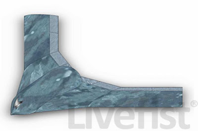
DRDO names AURA for the first time
Via LiveFist
http://www.scribd.com/doc/44208704/Indi ... Tech-Focus
http://livefist.blogspot.com/2010/08/wi ... y-iaf.html
Via LiveFist
http://www.scribd.com/doc/44208704/Indi ... Tech-Focus
http://livefist.blogspot.com/2010/08/wi ... y-iaf.html
Following a totally flat response to its surprise June RFI for a fleet of UCAVs, the Indian Air Force is throwing its weight fully behind India's indigenous UCAV programme, codenamed AURA. The highly classified programme, completely unknown until it was reported on here
Re: UAVs, Drones, Remote Surveillance Tech
Many pages back I had asked about the wheeled Nishant variant.
Obviously, Shiv ji has put up a picture of it from AI'09)
According to the latest Tech Focus
DRDO is working on:
However the below picture is not of a wheeled version of the Nishant. It was just being towed for a pic.

Obviously, Shiv ji has put up a picture of it from AI'09)
According to the latest Tech Focus
DRDO is working on:
A wheeled version of Nishant, use of colour video, and integration of synthetic aperture radar (SAR) are other developments in progress
However the below picture is not of a wheeled version of the Nishant. It was just being towed for a pic.
Re: UAVs, Drones, Remote Surveillance Tech
AURA speicfications from Techfocus seem to point towards a Rustom variant as an UCAVs rather than something like X-45. (guess only??)
Re: UAVs, Drones, Remote Surveillance Tech
How?vic wrote:AURA speicfications from Techfocus seem to point towards a Rustom variant as an UCAVs rather than something like X-45. (guess only??)
Re: UAVs, Drones, Remote Surveillance Tech
Boeing to offer ScanEagle UAV to India
Defenseworld
Defenseworld
Boeing is looking to offer its highly successful ScanEagle UAV to India, Dr. Vivek Lall, Vice President, Boeing Defense, Space and Security, India, said. In an interview to defenseworld.net, Dr. Lall said the ScanEagle will be offered to India as part of its homeland defence and security products range. Executives will be at hand at the Aero India 2011 show in Bangalore to explain features of the ScanEagle UAV.
Originally developed to help fishing boats track tuna schools and dolphins, the ScanEagle’s combination of range, 20 hour loiter time, and small logistical and operational requirement makes it unique. ScanEagle is launched via a pneumatic catapult, and flies pre-programmed or operator-initiated missions guided by GPS and its onboard flight control system. The ScanEagle has an all-terrain recovery system; it uses a “Skyhook,” in which the UAV catches a rope hanging from a 50-foot/ 15 meter high pole. The patented system allows ScanEagle to be runway-independent and operate from rough terrain or ships.
The ScanEagle requires fewer operators and less ground support than other long-endurance UAVs such as the Predator which requires a runway. Unlike mini-UAVs, this 4-foot aircraft with a 10 foot wingspan can keep its sensors on a pre-set target or flight path for 10-15 hours without requiring operator intervention. That’s over twice as long competing UAVs. In India, the ScanEagle could be of tremendous value in intelligence gathering in border areas and on the sea.
Re: UAVs, Drones, Remote Surveillance Tech
I can't understand endurance over range.
Both Nishant and ScanEagle have some comparable parameters, but ScanEagle out endures Nishant by some 4-5 times.
Both Nishant and ScanEagle have some comparable parameters, but ScanEagle out endures Nishant by some 4-5 times.
Re: UAVs, Drones, Remote Surveillance Tech
Endurance probably refers to how long it can stay up in the air?
Re: UAVs, Drones, Remote Surveillance Tech
^^It does sir.
But Multiplying the cruise speed with the endurance time is way ahead of the vehicle's said range.
But Multiplying the cruise speed with the endurance time is way ahead of the vehicle's said range.
-
P Chitkara
- BRFite
- Posts: 355
- Joined: 30 Aug 2004 08:09
Re: UAVs, Drones, Remote Surveillance Tech
Range for UAV may be determined by how far the UAV can be controlled by the ground station which in turn may be limited by the transmitter power if the signals are not routed through sats.
I am open to correction here.
I am open to correction here.
Re: UAVs, Drones, Remote Surveillance Tech
I'm sure we could find a use for this sucker on the western border....article from Gizmag
http://www.gizmag.com/korea-dodamm-supe ... dium=email
http://www.gizmag.com/korea-dodamm-supe ... dium=email
Re: UAVs, Drones, Remote Surveillance Tech
A pic of the Netra UAV in flight:
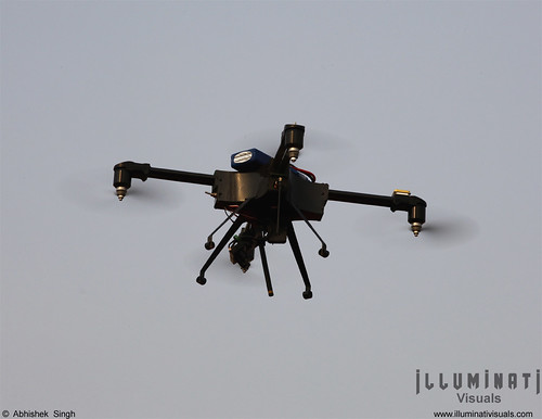
Netra UAV by DRDO by illuminativisuals.com, on Flickr
Picture Courtesy Illuminati Visuals
Netra UAV by DRDO by illuminativisuals.com, on Flickr
Picture Courtesy Illuminati Visuals
-
chackojoseph
- BRF Oldie
- Posts: 4297
- Joined: 01 Mar 2010 22:42
- Location: From Frontier India
- Contact:
Re: UAVs, Drones, Remote Surveillance Tech
Looking at the picture and pretending to be Singha. I say replace the two thinges hanging below the wing with helina and add the data link and he ball turret of Nishant on the nose module.
And we have a nice and cheap desi predator.
Re: UAVs, Drones, Remote Surveillance Tech
Below are new images posted by Shiv Aroor of Nishant UAV in Grey Color scheme... 
Re: UAVs, Drones, Remote Surveillance Tech
can they fit a stealthy airframe for the Lakshya PTA, now that they have given it an all digital control system and hence can be pre-programmed to simulate cruise missile trajectories, ideal progression would be simulating stealthy airframes
Re: UAVs, Drones, Remote Surveillance Tech
x-post from Space program thread:
It should be possible to put this system on a satellite ... With a constellation of 24 satellites one can have 4 satellites overhead at any point on the planet, at any time (e.g. GPS). It may make sense to have the satellites beam the video up to satellites in a higher, geostationary orbit, and then down to earth stations.With Air Force's new drone, 'we can see everything'
By Ellen Nakashima and Craig Whitlock
Washington Post Staff Writers
Sunday, January 2, 2011; 12:09 AM
In ancient times, Gorgon was a mythical Greek creature whose unblinking eyes turned to stone those who beheld them. In modern times, Gorgon may be one of the military's most valuable new tools.
This winter, the Air Force is set to deploy to Afghanistan what it says is a revolutionary airborne surveillance system called Gorgon Stare, which will be able to transmit live video images of physical movement across an entire town.
...
The development of Gorgon Stare began about 18 months ago. It is based on the work of Air Force scientists who came up with the idea of stitching together views from multiple cameras shooting two frames per second at half-meter resolution. Currently full-motion video is shot at 30 frames per second from one camera mounted on a Predator or the larger Reaper drone. That makes for more fluid video, but also more difficulty in assembling frames quickly to get the wide-area view.
Technological advances now make it possible for a soldier on the ground to receive any portion of a panoramic view in real time, streamed to a portable device about the size of an iPad, Poss said. At the same time, nine other soldiers can get the same or a different view. The images will be stored so analysts can study them to determine, for instance, who planted an improvised bomb or what the patterns of life in a village are.
http://www.washingtonpost.com/wp-dyn/co ... 90_pf.html
Re: UAVs, Drones, Remote Surveillance Tech
EADS looking for international partners for UAV programs, in discussions with India
EADS asks Europe to make a choice
EADS asks Europe to make a choice
Gallois asked the wider defence industry to embrace more multi-national co-operation in the development of aircraft and UAVs, describing EADS’ intent to form ‘associations’ with competitors especially in regard to targeting markets in ‘emerging countries’.
This, he added, was part of a ‘Three Pillars’ approach to dealing with Europe, emerging countries and the US. ‘We are going to partnership. If we want to sell in Brazil or India, we need to have a partner. We are discussing [this] with a lot of them,’ Gallois said while refusing to reveal specific information on individual companies.
Re: UAVs, Drones, Remote Surveillance Tech
After Vihang Netra, SMEs float first mini-UAV
With a packing set that weighs 2.5 kg, the UAV can be backpacked and hand-launched. It’s battery operated with a maximum speed of 50 kmph and can be airborne for 45 minutes. “The maximum altitude is 1,500 metres. We have equipped it with a way point based GPS navigation, 2.4 GHz and 900 Mhz radio links and day/night use CCD camera. Given the size and ease of operations, this is the most suitable option for the Armed Forces to survey a region, carry out anti-insurgency missions...customs and coast guard missions, police and homeland security and so on.
The UAV can have extended range, endurance, night vision camera — the first-ever in the country — pan-and-tilt camera and digital link, according to Kamlapurkar, who added, “The UAV that has a range of five km, sends back data to the ground station... There are options such as way point navigation, abort mission, in-flight way point changes, hovering around target, real time target co-ordinate transmission and so on."
-
chackojoseph
- BRF Oldie
- Posts: 4297
- Joined: 01 Mar 2010 22:42
- Location: From Frontier India
- Contact:
Re: UAVs, Drones, Remote Surveillance Tech
DRDO’S UAV “Nishant” completes confirmatory flight trials with Indian Army
The successful flight trials were conducted by the Army before taking delivery of a set of four Nishant – UAVs together with ground systems. The trials were witnessed by Lt Gen Vinod Nayanar AVSM, Director General Artillery, Shri P S Krishnan, Distinguished Scientist and Director ADE, Shri G Sivasankaran, Project Director-Nishant, senior scientists from ADE and DEAL, Army Trial Team and the representatives from the Army regiment that is ultimately going to use the equipment. The performance of the pay load sensors in particular has been better than even the imported UAVs with the Army. It is expected that more of such equipment will soon be purchased by the users.
The successful flight trials were conducted by the Army before taking delivery of a set of four Nishant – UAVs together with ground systems. The trials were witnessed by Lt Gen Vinod Nayanar AVSM, Director General Artillery, Shri P S Krishnan, Distinguished Scientist and Director ADE, Shri G Sivasankaran, Project Director-Nishant, senior scientists from ADE and DEAL, Army Trial Team and the representatives from the Army regiment that is ultimately going to use the equipment. The performance of the pay load sensors in particular has been better than even the imported UAVs with the Army. It is expected that more of such equipment will soon be purchased by the users.
Re: UAVs, Drones, Remote Surveillance Tech
The UAV was accepted after almost 14 years of trials. Lets hope that the Indian military orders it in large numbers.