WTF is this contraption in da middle of Pakh-istan. Looks like a Mud airfield and SOme Missile launch sites to me. Could this be da place where they fotograph their chinese paint-job Miss-iles ???
31* 26' 01.97
72* 01' 34.35
Google Earth updates more cities and airports in India
Pakistani Military Facilities near Khanpur Dam.
72.894473390225,33.78369291949836
Possible location of solid fuel missile production plant at Tarnawah. Note there is a second facility at 72.87365772149275,33.80264547316915 .
The Khanpur dam area is just north of the Margalla Hills and represents easily defensible airspace.
72.894473390225,33.78369291949836
Possible location of solid fuel missile production plant at Tarnawah. Note there is a second facility at 72.87365772149275,33.80264547316915 .
The Khanpur dam area is just north of the Margalla Hills and represents easily defensible airspace.
Seems like China is serious about engaging India. How serious? More than you think,
http://www.theregister.co.uk/2006/07/19 ... n_mystery/
http://www.theregister.co.uk/2006/07/19 ... n_mystery/
-
Cain Marko
- BRF Oldie
- Posts: 5393
- Joined: 26 Jun 2005 10:26
eek! That is truly scary esp. considering how GOI leaders and babus are taking it easy. What the hell would they need a scale model thi size for????Harry wrote:Seems like China is serious about engaging India. How serious? More than you think,
http://www.theregister.co.uk/2006/07/19 ... n_mystery/
Regards,
CM.
I think you mean army officers - not pilots?Harry wrote:Such a facility would be incredibly useful. During Kargil, the IAF Mi-17 gunship pilots were'nt really familiar with the terrain and had to carry Army pilots onboard. The one that was lost incidentally did not have an army pilot onboard and had trouble exiting. When will we ever wake up?
The entire air-base is nothing but HAS shelters which blend in very well. In comparison, IAF bases seem to leave a lot of assets in the opens. The TSPians *appear* a lot more prepared survive a bombingpauldevis wrote:I don't see any F-16's at Sargodha, just a couple of Mirage 5's and some F-7's. Lots of HAS shelters though.akumar wrote:Posted earlier by Shalav This paki airbase will be receive the full attention of IAF in the very first hours of hostility. Can the gurus here deconstruct Sargodha?
1. Spot F16’s.
The long water body gave it away at first glance and I almost immdiately recognized the area that the Chinese military has modeled in such large scale. The long water body is Pengong-Tso lake that has Chinese occupying Indian territoty by 8 Km from International boder, from 1962 war. The distinctive shape of other other water bodies match. The heart of the modal is Indian territory of Aksaichin that is under Chinese occupation. And this is a frigging extreamly high resolution 1:500 scale modal which is itself 900 meter x 700 meter (on ground corresponding to 450 Km x 350 Km). Thus an average Chinese 1.5 meter tall gets a view of an aircraft at 750meter (2250 feet) altitude from surface. Could be very useful for pilots indeed.Harry wrote:Seems like China is serious about engaging India. How serious? More than you think,
http://www.theregister.co.uk/2006/07/19 ... n_mystery/
Pls see on Google 33.5 North 78.5 East, the scale modal corresponds to 80 degree azimuth. Almost 40% of the area in that map is Indian land.
The scale modal itself is located at :
<longitude>105.9509688847253</longitude>
<latitude>38.26565065676576</latitude>
<heading>72.51728515817638</heading>
The big scale modal does indicate that it is Chinese war-gaming tool. I think it is also of good use for military pilot visualization/familieriazation.
BTW do you see the huge tower nearby, atop which the war gaming teams can get a command view of war unfolding below.
Yeah, I know he meant AAC pilots - but I think he is mistaken - Gp Capt Sinha mentions that Army officers from the ground units - in his case Maj Adhikari -accompanied them - not the AAC Pilots.Shishir wrote:I think Harry meant Army Aviation pilots..
Well spotted! - it is indeed the Pangong Tso - Chushul Area.Arun_S wrote:[quote= to 450 Km x 350 Km). Thus an average Chinese 1.5 meter tall gets a view of an
The big scale modal does indicate that it is Chinese war-gaming tool. I think it is also of good use for military pilot visualization/familieriazation.
BTW do you see the huge tower nearby, atop which the war gaming teams can get a command view of war unfolding below.
Seems like the peaks/ridges are painted white to simulate snow, and blue for the lake water. I am wondering what month does the snow cover correspond to. I dont know the local snowfall patterns, but since the snow is only on the peaks I suppose it corresponds to a month in summer (what season are they preparing for is da question). However, the area is dry, so it could have a similar snow cover in winter too. Also, there's something that looks like a airbase, due north, but looks abandoned;38 29' 28.01" N, 106 00' 35.44" E.Jagan wrote:Well spotted! - it is indeed the Pangong Tso - Chushul Area.Arun_S wrote:[quote= to 450 Km x 350 Km).
The big scale modal does indicate that it is Chinese war-gaming tool. I think it is also of good use for military pilot visualization/familieriazation.
Added later: Just realized ....they could paint the snow cover and modify as they want it. And if they need help with a paint-job, their all-weather friends to the south-west would be glad to help, I'm sure.
Hi Sri: Those mountains are really high, the snow cover you see there is above snow-line. When I went there in peak of summer (August) the snow has almost receded to what you see there. During winter the 130Km long lake freezes and there is thin snow everywhere on gound, the temprature in winter is -30 to -50 degrees C and ground is frosted down few feets.
Pls see photo below taken in August, and these are the mountains seens from ground level, in between peaks one gets to peek on th ehigher mountains behind that have very thick snow cover.
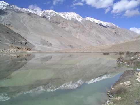
Pls see photo below taken in August, and these are the mountains seens from ground level, in between peaks one gets to peek on th ehigher mountains behind that have very thick snow cover.
Look more carefully to its western side. Looks like this arifield was made for Chinese missile silo located on western side. The runway and apron tire marks show it was a heavily used airfield, and the landings were 90% of the time due North on runway 01.SriKumar wrote:Also, there's something that looks like a airbase, due north, but looks abandoned;38 29' 28.01" N, 106 00' 35.44" E.
Am I the only one here who believes that there's more to those mountains in the west, than meets the eye?Arun_S wrote:Look more carefully to its western side. Looks like this arifield was made for Chinese missile silo located on western side. The runway and apron tire marks show it was a heavily used airfield, and the landings were 90% of the time due North on runway 01.SriKumar wrote:Also, there's something that looks like a airbase, due north, but looks abandoned;38 29' 28.01" N, 106 00' 35.44" E.
Nice pic. Post-card quality, I'll say. You might want to water-mark it if it stays on public domain.Arun_S wrote:
Pls see photo below taken in August, and these are the mountains seens from ground level, in between peaks one gets to peek on th ehigher mountains behind that have very thick snow cover.
http://www.indianexpress.com/story/9972.html
From sky, see how China builds model of Indian border 2400 km away
Shiv Aroor
Posted online: Saturday, August 05, 2006 at 0000 hrs
Satellite images show Aksai Chin terrain replicated, with peaks, for possible troop exercises
NEW DELHI, AUGUST 4:The discovery of what is considered a military establishment in China’s Northern plains by a Google Earth user from Germany has kicked up a storm on the Net’s strategic forums. Here’s why: The establishment, snapped from Google’s free satellite imagery software, houses a startlingly accurate scale model of a highly sensitive stretch of the disputed Sino-Indian border.
A careful study of the model, located at a large military complex in China’s Huangyangtan province, likely used for training and familiarisation of troops, helicopters and infantry vehicles, shows that it is built to scale based on a stretch 2,400 km away along the Aksai Chin area bordering Ladakh, part of the stretch through which invading Chinese forces entered in the 1962 war.
The facility, full with uncharacteristic and man-made snow peaks, glacial lakes and snow rifts—ironically in the middle of an arid plain—is flanked by a large military depot with buildings and at least a hundred military trucks.
The Army did not confirm that it was aware of the facility, but officially told The Indian Express, “Militaries are always known to simulate potential conflict zones as a standard practice. There is absolute peace and tranquility on the border with China, a disputed border that the two governments are resolving through peaceful dialogue. It is nothing alarming, these are standard training methodologies.â€
Thanks. I have it on very high resoltion that is suitable for 1 meter x 1.4 meter enragement without losing much resolution, and that is watermarked with my copyright. It is one the best photos I have taken ever.SriKumar wrote:Nice pic. Post-card quality, I'll say. You might want to water-mark it if it stays on public domain.Arun_S wrote:
Pls see photo below taken in August, and these are the mountains seens from ground level, in between peaks one gets to peek on th ehigher mountains behind that have very thick snow cover.
KMZ file containing Pakistani Nuclear, missile and Defence industry related sites
List contains :
A Q Khan's House
Chasma Nuclear Reactor
Heavy Water Extraction Plant
KANUPP
Khusab Nuclear Reactor
Khusab PUREX facility under construction
KRL Complex at Kahuta
National Defence Complex, Fatehjung
Pakistan's Project Management Organisation
Tarnawah Missile Complex 1
Tarnawah Missile Complex 2
Weapons Storage Facility at Sargodha Kirana Hills
The .kmz file was sent by
Maverick
If the rumour about Google updating it's image database on the number of users visiting a particular location is true, then please pay a speshul onlee visit to the Chasma Nuclear site.
Sorry Ananth, No idea on those three places.Ananth wrote:paul:
Any luck on muridke, lahore (Jamat-ul-dawa) + binori madrassa karachi. They are within/near city so will be difficult to locate them without a well known landmark. Also, I am interested to see if google got any close ups near LOC, to get more info on these traning camps that we hear.
About the terrorist training camps, google had put up high res pictures of Muzafarrabad after the earthquake, but then removed them (they had mentioned that it was going to be temporary ).
Google Earth Link (KMZ) open with google earth... http://bbs.keyhole.com/ubb/download.php?Number=484568
Connect with Jagan's post on the Indian express story.
Connect with Jagan's post on the Indian express story.
I havent seen your coords yet (Will do it after going home) , but if its near Bapatla (just south of vijaywada), it could well be AFS Suryalanka, where they regularly test SAMs.akumar wrote:Is that a non-functional SAM placement in the Andra Pradesh coast? Wonder what was it that required a SAM cover.
15.84005331784013, 80.48555767824541
I am fascinated by the Weapons Storage Facility at Sargodha Kirana Hills. There are some perfectly circular black objects in this facility. Are these the M-11 Silos? The facility is constructed in the shadow of the hills so any attack on the Eastern Side has to plan on avoiding the hills. It is also quite far away from the main Sargodha airbase.
And PhotoChor's house looks like a palace.
And PhotoChor's house looks like a palace.
Last edited by VikramS on 07 Aug 2006 23:40, edited 1 time in total.
It is right next to Bapatla, south of Vijaywada, and facing the sea.Jagan wrote:I havent seen your coords yet (Will do it after going home) , but if its near Bapatla (just south of vijaywada), it could well be AFS Suryalanka, where they regularly test SAMs.akumar wrote:Is that a non-functional SAM placement in the Andra Pradesh coast? Wonder what was it that required a SAM cover.
15.84005331784013, 80.48555767824541
AFS Suryalanka it is.VikramS wrote:It is right next to Bapatla, south of Vijaywada, and facing the sea.Jagan wrote: I havent seen your coords yet (Will do it after going home) , but if its near Bapatla (just south of vijaywada), it could well be AFS Suryalanka, where they regularly test SAMs.
Check these photos out
http://www.geocities.com/drnitin_p/albu ... force.html
The only time i ever saw an SA2 being transported..
Has nothing to do with India, I want to know what the hell is this
40°27'26,31 N
93°23'27,37 E
Is it possible to manuplate Google Earth like fadding the image on a particular area or attaching a particular area with virus......you catch deadly cold if you visit that site as it happens to me whenever I visit the Not-so -Indian Express.
40°27'26,31 N
93°23'27,37 E
Is it possible to manuplate Google Earth like fadding the image on a particular area or attaching a particular area with virus......you catch deadly cold if you visit that site as it happens to me whenever I visit the Not-so -Indian Express.
Check this out : You can steer the plane with the arrow keys and hit space to shoot in this arcade game/ proof of concept... and marvel at the scenery, as it all takes place on top of Google Maps satellite imagery.rsingh wrote: Is it possible to manuplate Google Earth like fadding the image on a particular area or attaching a particular area with virus......
http://www.isoma.net/games/goggles.html
Originally posted at : http://blog.outer-court.com/archive/2006-08-08.html#n64
Too bad our best friends are still not available in the map.
