Indian Space Program Discussion
Re: Indian Space Program Discussion
This is where ISRO has a huge problem - lack of adequate transponders. All entities in India can only use transponders from ISRO or those that ISRO has leased. Lack of them affects DTH, VSAT, etc. Several satellite failures and a couple of launch failures have put them in a position where they are only 50% of target.
Re: Indian Space Program Discussion
Second test of S-200 successful: http://www.domain-b.com/aero/space/sate ... oster.html
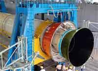
The Indian Space Research Organisation (ISRO) successfully carried out the second test of the S-200 rocket booster early this month. The massive booster will form the strap-on stage for the Geosynchronous Satellite Launch Vehicle Mark-III's (GSLV Mk-III) maiden flight scheduled for 2012-13.
The S-200 booster. Image: ISROThe strap-on S-200 rocket booster is stated to be the biggest in Asia and the third largest in the world, smaller than the ones that put NASA's shuttle into space and Arianespace's Ariane-5 rocket.
The strap-on stage provides an initial boost to the rocket as vehicle load is the heaviest at the take-off stage and the force of gravity is the maximum.
The GSLV Mk-III, which is now in an advanced stage of development, will have two strap-on boosters fixed to the rocket. The huge rocket will take communication satellites of the four tonnes class into orbit.
The current version of the GSLV can orbit communication satellites of two tonnes weight.
The GSLV Mk-III's operationalization will drastically reduce ISRO's dependence on Arianespace to orbit its four-ton class of communication satellites.
-
Varoon Shekhar
- BRF Oldie
- Posts: 2178
- Joined: 03 Jan 2010 23:26
Re: Indian Space Program Discussion
"Second test of S-200 successful"
Excellent. Now awaiting news about progress on the C-20 or C-25 cryogenic engine. It does appear, from items like this, and statements by the ISRO chairman, that the development of the GSLV mark 3 is picking up.
Excellent. Now awaiting news about progress on the C-20 or C-25 cryogenic engine. It does appear, from items like this, and statements by the ISRO chairman, that the development of the GSLV mark 3 is picking up.
Re: Indian Space Program Discussion
This article gives a timeline for the GSLV-MKIII's launch - end 2012 or early 2013.
http://www.asianscientist.com/topnews/i ... t-booster/
http://www.asianscientist.com/topnews/i ... t-booster/
Re: Indian Space Program Discussion
A video of the second static test of the GSLV Mk III's S-200 stage. Watch the flex nozzle at workSwamyG wrote:Second test of S-200 successful: http://www.domain-b.com/aero/space/sate ... oster.html
Youtube
Re: Indian Space Program Discussion
More news giving out ISRO's thoughts on another launch site: http://www.thehindubusinessline.com/ind ... 455936.ece
Can some guru elaborate on Dathan's views? As India lies north of the equator, wouldn't going south benefit?
I thought there were greater benefits of launching satellites closer to the equator. Just like this article explains: http://www.aerospaceweb.org/question/sp ... 0080.shtmlMr M.C. Dathan, Director of SDSC, told Business Line, “Theoretically, if we go slightly towards the North (of Sriharikota) there will be an advantage of steering the polar launcher. We can get a payload benefit (or capability to lift an additional) 300 kg or so.”
Can some guru elaborate on Dathan's views? As India lies north of the equator, wouldn't going south benefit?
Re: Indian Space Program Discussion
Can someone state in a line or two what happens to an engine of this complexity once the satellites are put into orbit please?arun wrote:A video of the second static test of the GSLV Mk III's S-200 stage. Watch the flex nozzle at workSwamyG wrote:Second test of S-200 successful: http://www.domain-b.com/aero/space/sate ... oster.html:
Youtube
Re: Indian Space Program Discussion
^^
Are you asking about the SRBs? NASA retrieves the steel casing of the SRBs. They parachute down. Last I read ISRO did not have any plans to retrieve.
Are you asking about the SRBs? NASA retrieves the steel casing of the SRBs. They parachute down. Last I read ISRO did not have any plans to retrieve.
Re: Indian Space Program Discussion
Thanks for reply. I was talking about engines. I read somewhere that actual engines used in GLSV are single use so I was wondering how that was. Since the engines are tested well many times so I now assume that it is not single use. Just making sure.SwamyG wrote:^^
Are you asking about the SRBs? NASA retrieves the steel casing of the SRBs. They parachute down. Last I read ISRO did not have any plans to retrieve.
Re: Indian Space Program Discussion
I have said the same in this forum before
All ISRO solid motors, liquid / cryo engines are single use. (They are trying for multi use ones.) The current set up is that ISRO develops 3 parts for an actual one to be used. One is used up in the testing, one used for launch, and the rest one retained for next launch or research purposes
All ISRO solid motors, liquid / cryo engines are single use. (They are trying for multi use ones.) The current set up is that ISRO develops 3 parts for an actual one to be used. One is used up in the testing, one used for launch, and the rest one retained for next launch or research purposes
Re: Indian Space Program Discussion
Geo stationary and other equatorial orbits require launch vehicles launched close to equator. This is to get the maximum advantage of earth's rotation. But for polar launches, it only be need that you get a better north to south or south to north axis for launch. Maybe they are planning a site in Orissa to avoid the dog leg manuvore of current PSLV launches to aoivd SrilankaSwamyG wrote:More news giving out ISRO's thoughts on another launch site: http://www.thehindubusinessline.com/ind ... 455936.ece
I thought there were greater benefits of launching satellites closer to the equator. Just like this article explains: http://www.aerospaceweb.org/question/sp ... 0080.shtmlMr M.C. Dathan, Director of SDSC, told Business Line, “Theoretically, if we go slightly towards the North (of Sriharikota) there will be an advantage of steering the polar launcher. We can get a payload benefit (or capability to lift an additional) 300 kg or so.”
Can some guru elaborate on Dathan's views? As India lies north of the equator, wouldn't going south benefit?
Re: Indian Space Program Discussion
If the second space port is planned mainly for polar launches, they could also go south towards Kanyakumari. It would not be prone to cyclones like any site on the Bay of Bengal is and would therefore be available for more days in a year. It would also be close to the key ISRO labs for solid and liquid engines.
Long ago, there was a plan for two launch sites - with Balasore planned for polar launches and missile testing. The latter never happened because of the need to firewall ISRO from DRDO for geopolitical reasons. Things seem to have come full circle.
Long ago, there was a plan for two launch sites - with Balasore planned for polar launches and missile testing. The latter never happened because of the need to firewall ISRO from DRDO for geopolitical reasons. Things seem to have come full circle.
Re: Indian Space Program Discussion
The main reason to want a launch for a geo satellite as close to the equator as possible is to minimize the fuel used for changing the inclination of the satellite. If a satellite is launched from a spot on the equator, it can be launched due east and it's orbit will be along the same inclination as the final one. If, however, it is launched from a place north of the equator, it is launched south east. Then fuel is used up to 'turn' it towards an orbit right on top of the equator in a west to east direction.
For a polar orbit, if you can launch the satellite due south, it is in its final orbital inclination. Sriharikota is not perfect for polar launches since due south of it lies Sri Lanka requiring the PSLV to be launched in a south-easterly direction and then turned southwards once it is clear of Sri Lanka. A site like Balasore or Thumba/Kanyakumari would mean that it can be launched southwards with no land along the way, increasing payload capacity by 300kg (~20%). That is a lot.
For a polar orbit, if you can launch the satellite due south, it is in its final orbital inclination. Sriharikota is not perfect for polar launches since due south of it lies Sri Lanka requiring the PSLV to be launched in a south-easterly direction and then turned southwards once it is clear of Sri Lanka. A site like Balasore or Thumba/Kanyakumari would mean that it can be launched southwards with no land along the way, increasing payload capacity by 300kg (~20%). That is a lot.
Re: Indian Space Program Discussion
how about Tuticorin as a spaceport ?
Re: Indian Space Program Discussion
^^^
They launch ( injection of satellite ) the satellite in such a way that it will be released at the intended inclination ( generally about 98 deg ) while crossing equator from North to South ( because the inclination by definition is measured that way ) at the specified Local Solar Time. That is why they have to bypass the landmass and so the dog-leg maneuver.
Having the site on West coast will nullify the advantage of Earth's rotational torque.
I have a question :
If we launch from East coast the initially we get advantage of Earth Rotation but we anyway have to make a U turn ( Whether Srilanka is there or not ) for release in the required inclination. How much payload penalty will be there if we have a launch site on West coast?
Another question is it not feasible to launch polar satellite from Shar towards North at Night ( The polar satellite would travel in that direction at night )?
I tried to plot the satellite path and found that the satellite is continuously passing along the South coast upto Bangladesh. But then rocket could first rise in east direction over sea and when in between Shar and Bangkok it could turn NE and then to 82 ( Complment of 98 deg ) deg ascending before reaching Bangladesh ( say at the lattitude of Bhubneshwar ) and releases the satellite in ascending part of orbit at night.
Re: Indian Space Program Discussion
If they are looking to go up north and gain some benefits, then it very well could be for PSLVs, just like the article pointed out. So the northern site for PSLV, and the southern for GSLVs?
Re: Indian Space Program Discussion
http://www.moneycontrol.com/news/busine ... 87702.html
Referring to 'GAGAN', the satellite-based air navigation system (SBAS) being developed by AAI and ISRO, he said all necessary equipment was already in place and the process of its certification was currently on.
"Certified signals from this system will be available for use from June 2013," he said, adding that aircraft and even helicopters were now equipped with SBAS and ground-based navigation systems to which these signals would be available.
The signals would be available over the entire Indian airspace as well as the Indian Ocean region from Australia to some African countries, subject to these countries installing receiver equipment, Agrawal said.
Re: Indian Space Program Discussion
Why cant Thumba be developed rather going for a new site?
Re: Indian Space Program Discussion
Finally the UARS satellite has fallen sometime back in the Pacific.
Details posted in BRF Thread : http://forums.bharat-rakshak.com/viewto ... 4#p1168674
Details posted in BRF Thread : http://forums.bharat-rakshak.com/viewto ... 4#p1168674
-
Varoon Shekhar
- BRF Oldie
- Posts: 2178
- Joined: 03 Jan 2010 23:26
Re: Indian Space Program Discussion
SSSalvi, Krish and others knowledgeable about ISRO, excuse the ignorance, but when a new ground station for Oceansat-2 is commissioned, that means that the data from the satellite will be augmented and concentrated on more, doesn't it? Because the satellite has been in orbit for 2 years, so the pictures from it must have been processed at the normal facility. Now they would have a dedicated facility for Oceansat, instead of having to disseminate the info from the general station. Is that what is happening?
Re: Indian Space Program Discussion
^^^
( What I am giving is my view on what is possible and I really do not know the factual info )
1. The new Earth Station ( ES ) belongs to INCOIS, an agency dedicated to Ocean Studies. ( Its mission statement from its website is " To provide ocean information and advisory services to the society, industry, government and scientific community through sustained ocean observations and constant improvements through systematic and focused research " ). So having an ES for receiving data from Oceansat is just logical.
2. The satellite transmits its payload data through an X Band downlink from satellite to ES. So one can have any number of stations in its footprint. But there is a catch. The data is being transmitted in X-Band which is a very high frequency so the transmit antenna has a very narrow beamwidth. Moreover the onboard antenna has a pointing mechanism which continuously orients the signal beam to the intended receiving station.
3. The INCOIS is almost in Hyderabad city whereas the ISRO facility is about 50kms south of Hyderabad.
Now comes a question for which I have no answer:
Does the satellite have a transmit power which can give a sufficient signal margin to receive data by 7.5M antenna systems ( G/T of about 31 db/k ) even when the transmit beam is pointed 50 kms away from the station?
If the answer is yes then both ISRO and INCOIS can receive data simultaneously.
If it is 'no' then we can assume that the data is primarily being received by INCOIS.
Apart from these two stations the data is also being received by a station in Alaska which is used to downlink the recorded ocean data. ( I am quoting from http://www.nrsc.gov.in/p2p/P2P_JAN11.pdf ).
4. Till the new ES was commissioned the data was being received at ISRO station and processed data would have been sent to INCOIS since it is a nodal agency for this type of data. This would involve some delays because the processing takes time and the finished product does not get ready at least for a few hours. This delay would be avoided if the data is directly being received by actual user agency rather than be a receiving agency which then sends it to the user after some delay.
5. The data requirement being specified by INCOIS is appropriate because being a user agency it can specify focussed set of data acquisition than the ISRO which would acquire data with no special focus based on imminent requirements. ( e.g. cyclones, fishing cycles etc ). Going by its mission statement we assume that INCOIS will provide data to any user just like what ISRO was doing.
6. The satellite would still be under custody of ISRO which will actually do the commanding because that operation requires a real insight into total satellite system which can be known only to ISRO. A single wrong command and the satellite would be a 'lost forever' property! One can't take chance.
-
Drishyaman
- BRFite
- Posts: 279
- Joined: 15 Aug 2010 18:52
- Location: Originally Silchar, Assam
Re: Indian Space Program Discussion
^^ INCOIS is a relatively new organisation. They are ramping up. 2-3 weeks back they were looking for people having experience in tsunami research.
Re: Indian Space Program Discussion
Does this new organization in its mandate study the coastal wind patterns for positioning of offshore wind turbines within the country's EEZ
Why can't be a sea launch platform be our second launchpad? the ship can load the PSLV sized rockets directly say from Kerala's ports
Why can't be a sea launch platform be our second launchpad? the ship can load the PSLV sized rockets directly say from Kerala's ports
Re: Indian Space Program Discussion
^^^
Relatively new .. yes.
But I have known this organization for at least 10 to 12 years .. right from the time that it was established in a small building atop a hillock.
Relatively new .. yes.
But I have known this organization for at least 10 to 12 years .. right from the time that it was established in a small building atop a hillock.
-
Bade
- BRF Oldie
- Posts: 7212
- Joined: 23 May 2002 11:31
- Location: badenberg in US administered part of America
Re: Indian Space Program Discussion
This note buried in that pdf link posted above is an even more significant development. If I recall correctly I had posted long back along similar lines to have a robust receiving station to get all 14 orbits of polar data for each day for any IRS series of satellites. This will reduce dependency on other International agencies a lot. The other option is to maintain 3-4 Geo-stationary satellites for data down-link from polar orbiters (like the TDRS system) which would be more expensive IMO.One of the most exciting challenges taken up by ISRO during the recent months is to establish an unmanned ground station in Antarctica near India’s third Antarctic research station ‘Bharathi’. It is to be built on an unnamed promontory between
Stornes and Broknes peninsula in the Larsemann Hills area, East Antarctica (69°24’-690 25’S latitude and 76°10’-76013’E longitude). The ground station will receive data from Indian Remote Sensing Satellites in S / X- Band and transfer the same to NRSC Earth station, Shadnagar A.P. (India) in near realtime through GEO Communications link. This facility will further enhance user outreach of onboard processed data through additional facility to the Svalbard (Norway) facility, close to North Pole. A two member NRSC team participated in the 30th Indian Antarctic Expedition to initialize the site selection and lay
the foundation.
Re: Indian Space Program Discussion
^^^
Oh Bade sab,
Bringing back memories of one of the last projects of yours truly.
Oh Bade sab,
Bringing back memories of one of the last projects of yours truly.
-
Bade
- BRF Oldie
- Posts: 7212
- Joined: 23 May 2002 11:31
- Location: badenberg in US administered part of America
Re: Indian Space Program Discussion
Salvi-ji, you are lucky if you worked on this as a last project.
Does any other country operate civilian earth station down links in Antarctica other than for communications and maybe for Antarctic missions ? Not that I know of. All use Svalbaard, Alaska and a smattering of stations at various univ campuses all over North America.
Does any other country operate civilian earth station down links in Antarctica other than for communications and maybe for Antarctic missions ? Not that I know of. All use Svalbaard, Alaska and a smattering of stations at various univ campuses all over North America.
Re: Indian Space Program Discussion
No 'known' stations in Antarctica. May be because there are no populated landmasses nearby.
Indian station could become a Dakshin Svalbard if really intended to do so.
Main problem is transmitting the collected data to mainland. Remote sensing satellites transmits data at 100s of Megabits per second. That data can be re-transmitted to mainland using geosync satellites which have transponders limited to about 36Mhz bandwith. Added to that is the fact that from this station look angle for geosync satellites is less than 5 deg so link margin limitations are encountered.
Arctics are near populated lands hence some stations are built there. ( data cables can run to places from where normal links are possible ). Even then the actual antennas at Svalbard are in unmanned land .. connected to a manned control room several kms near somewhat populated areas.
By the way ... India gets Svalbard data by .. yes, postal service!
Last edited by SSSalvi on 26 Sep 2011 20:56, edited 1 time in total.
-
Bade
- BRF Oldie
- Posts: 7212
- Joined: 23 May 2002 11:31
- Location: badenberg in US administered part of America
Re: Indian Space Program Discussion
That is what I thought about Antarctica based stations. Since others had the luxury of TDRSS type systems so never bothered. But this is a simple solution to that vexing problem and I am glad ISRO had been thinking about it for some time now. It has been two years since Oceansat-2 launch and I see no imagery at INCOIS. A bit sad about that.
Re: Indian Space Program Discussion
Air Force begins screening astronauts for maiden human space flight.
The Indian Air Force’s (IAF) Institute of Aerospace Medicine (IAM), which would be entrusted with the crucial role of screening and selecting the astronauts for the country’s maiden human space flight mission, has already initiated the ground work by developing state-of-the-art laboratories.
The Bangalore-based institute, which was an integral part of the Indo-Soviet manned space flight in the 1980’s, has developed various laboratories that can be used for screening potential astronauts.The institute also played a role in the medical monitoring team of India’s only cosmonaut, Wing Commander Rakesh Sharma.
The department of space and environment physiology has developed three laboratories, comprising the thermal chamber, micro gravity simulation, and lower body negative pressure (LBNP).
At the thermal chamber, temperature can be simulated to very high and low temperatures, which the astronauts could encounter during the mission. The space craft would rotate around the earth about 16 times and the astronauts would be exposed to varying temperatures.
This chamber would simulate various temperatures and get them accustomed. Likewise, at another laboratory, the effects of microgravity can be simulated, which cannot be created normally on Earth.
A high-performance human centrifuge, which can simulate various G-force levels, will also be housed in the institute.
Re: Indian Space Program Discussion
A very misleading headline by the news agency. I thought the IAF had actually started selecting future astronauts; what they're doing is setting up the facilities to do so, if those are needed at some time in the future.
-
Varoon Shekhar
- BRF Oldie
- Posts: 2178
- Joined: 03 Jan 2010 23:26
Re: Indian Space Program Discussion
"what they're doing is setting up the facilities to do so, if those are needed at some time in the future."
Not to nitpick, Vinit, but from the article, it does like the actual facilities are already established. Or is the Indian/DDM inaccurate on this score? You know what, I do remember reading about this institute and its facilities way back in the early 90's- and that only a few countries had them.
Not to nitpick, Vinit, but from the article, it does like the actual facilities are already established. Or is the Indian/DDM inaccurate on this score? You know what, I do remember reading about this institute and its facilities way back in the early 90's- and that only a few countries had them.
Re: Indian Space Program Discussion
Some facilities do exist (which are common for air force training) but the many specific facilities for training astronauts is yet to be established. The main facility that was to come up near Bangalore Airport (for which land has already been acquired partially) is yet to receive funding.Varoon Shekhar wrote:"what they're doing is setting up the facilities to do so, if those are needed at some time in the future."
Not to nitpick, Vinit, but from the article, it does like the actual facilities are already established. Or is the Indian/DDM inaccurate on this score? You know what, I do remember reading about this institute and its facilities way back in the early 90's- and that only a few countries had them.
-
Varoon Shekhar
- BRF Oldie
- Posts: 2178
- Joined: 03 Jan 2010 23:26
Re: Indian Space Program Discussion
^^^^mere picture put India in this space league or does the Mk3 need to fly too?
Re: Indian Space Program Discussion
^^^
AIS-Sat has now been renamed as VESSELSAT.
AIS-Sat has now been renamed as VESSELSAT.
Re: Indian Space Program Discussion
S^3, I have an e-mail to send to you from Spinster!
Re: Indian Space Program Discussion
thanks ramanaji