GSLV-Mk III launch program/post-launch analysis
Re: GSLV-Mk III launch program/post-launch analysis
taking a leaf from French book, would there be any advantage of a equatorial launch base say by leasing a island in IOR. how much difference does the location make between say sriharikota and baikanour?
Re: GSLV-Mk III launch program/post-launch analysis
Which Island would meet the requirements?
Re: GSLV-Mk III launch program/post-launch analysis
^^
Why lease from any other country when India has the Andaman and Nicobar Islands? Continue GTO launches from Sriharikota and do Polar Orbit launches from the A&N islands. The distance from Sriharikota to Port Blair is about 1400 kms. I don't know what some people were whining about constraints that ISRO faces about where the first stage lands. There was a photograph on this thread about 1st stage separation taken from Chennai, so how far downrange will that first stage crash into the sea if that stage separation event was photographed from Chennai? Even when SpaceX does a GTO launch the first stage is recovered on a barge about 650 kms downrange, about half the distance to Port Blair from Sriharikota. The A&N launch site will do away with the Sri Lanka obstruction as a north launch has more than 2000 kms of sea to the Bangla Desh coast and a launch south has no land at all till Antartica.
Why lease from any other country when India has the Andaman and Nicobar Islands? Continue GTO launches from Sriharikota and do Polar Orbit launches from the A&N islands. The distance from Sriharikota to Port Blair is about 1400 kms. I don't know what some people were whining about constraints that ISRO faces about where the first stage lands. There was a photograph on this thread about 1st stage separation taken from Chennai, so how far downrange will that first stage crash into the sea if that stage separation event was photographed from Chennai? Even when SpaceX does a GTO launch the first stage is recovered on a barge about 650 kms downrange, about half the distance to Port Blair from Sriharikota. The A&N launch site will do away with the Sri Lanka obstruction as a north launch has more than 2000 kms of sea to the Bangla Desh coast and a launch south has no land at all till Antartica.
-
vina
- BRF Oldie
- Posts: 6046
- Joined: 11 May 2005 06:56
- Location: Doing Nijikaran, Udharikaran and Baazarikaran to Commies and Assorted Leftists
Re: GSLV-Mk III launch program/post-launch analysis
Plenty available in the Maldives. Just take over one of the dead beat money losing "resorts" in one of the islands closer to the equator and a clear launch path to the east and south. Perfect for both equatorial AND polar launches.shiv wrote:Which Island would meet the requirements?
However, the vehicle config has to change. It has to be integrated, in India(horizontally) , rolled on to a roll on roll off kind of ship , taken there, jacked up vertically and filled with fuel and fired. That simply leaves out solid motors that weigh a couple of 100 tons each. You are looking for an all liquid vehicle.
There is no way anyone is going to replicate a VSSC & SHAR in any foreign location. The best you can do is locate just the launch pad there. Sea Launch is the best attempt there for that kind of thing. However, it got caught in politics (Ukranian rocket, powered by Russian engine and launching commercial US satellites .. ) and conflicting commercial interests and now it has been sold in bankruptcy to a Russian S7 group , who can resurrect it.
India could have bid for Sea Launch assets if we had been far sighted. This is another loss on the lines of the Varyag to China , were instead of buying out the half complete Varyag , we went and paid big money for a "free" burnt out hulk.
Re: GSLV-Mk III launch program/post-launch analysis
Do all launches "appear" to go SouthEast because of westward rotation of the earth? If that is correct - he earth rotates at 1600 km per hour at the equator I think and here is some pure guesswork:
If a rocket is launched southwards and the first stage burns out at 2 minutes the surface of the earth the earth would have shifted just 50 km relative to the sat. But the boosters would take a while to fall from 50 km maybe as much as 1000 seconds as per my guesstimate. By that time the earth would have rotated westward a further 450 odd km.
So as per my guesswork there should be no landmass within 500 km east and south of the launch point for a first stage that burns for 2 minutes and goes up to 50 km
If the first stage burns longer and takes the rocket higher then that 500 km becomes much longer. Basically Malaysia, Indonesia and Australia would be our targets to hit with the first and second stages. All guesswork. If anyone knows better please put an implant in the edentulous gap.
Last edited by shiv on 11 Jun 2017 08:58, edited 1 time in total.
Re: GSLV-Mk III launch program/post-launch analysis
^^
Kourou (Ariane launch site) is 5 deg North latitude, Cape Canaveral is 28 deg North latitude, Sriharikota is 13 deg North latitude, Port Blair is 11 deg North latitude and Car Nicobar is 9 deg North latitude. The differential gravitational assist between Kourou and Srihaikota is about 140 kmph. A launchpad on the A&N Islands will reduce that differential......
Kourou (Ariane launch site) is 5 deg North latitude, Cape Canaveral is 28 deg North latitude, Sriharikota is 13 deg North latitude, Port Blair is 11 deg North latitude and Car Nicobar is 9 deg North latitude. The differential gravitational assist between Kourou and Srihaikota is about 140 kmph. A launchpad on the A&N Islands will reduce that differential......
Re: GSLV-Mk III launch program/post-launch analysis
Yes Maldives would be good.vina wrote:Plenty available in the Maldives. Just take over one of the dead beat money losing "resorts" in one of the islands closer to the equator and a clear launch path to the east and south. Perfect for both equatorial AND polar launches.shiv wrote:Which Island would meet the requirements?
Why not Sri Lanka? They need the investment. Would the Chinese, for instance, find Sri Lanka a good launch area?
Re: GSLV-Mk III launch program/post-launch analysis
>>So as per my guesswork there should be no landmass within 500 km east and south of the launch point for a first stage that burns for 2 minutes and goes up to 50 km
Since the earth rotates eastwards it should read as no landmass west and south of the launch point. Since the rocket is headed south and the gravitational force is pulling east, the expended stage will tend to land west of the due south straight line launch direction but not by 500 kms because of the gravitational assist in an easterly direction.
Since the earth rotates eastwards it should read as no landmass west and south of the launch point. Since the rocket is headed south and the gravitational force is pulling east, the expended stage will tend to land west of the due south straight line launch direction but not by 500 kms because of the gravitational assist in an easterly direction.
Re: GSLV-Mk III launch program/post-launch analysis
ldev wrote:>>So as per my guesswork there should be no landmass within 500 km east and south of the launch point for a first stage that burns for 2 minutes and goes up to 50 km
Since the earth rotates eastwards it should read as no landmass west and south of the launch point. Since the rocket is headed south and the gravitational force is pulling east, the expended stage will tend to land west of the due south straight line launch direction but not by 500 kms because of the gravitational assist in an easterly direction.
-
vina
- BRF Oldie
- Posts: 6046
- Joined: 11 May 2005 06:56
- Location: Doing Nijikaran, Udharikaran and Baazarikaran to Commies and Assorted Leftists
Re: GSLV-Mk III launch program/post-launch analysis
The rocket and the satellite too are spinning along with the earth at 1600 km/hr! So the relative velocity wrt. earth is zero ! The easiest way to analyse this with reference to the earth as the fixed frame. So don't consider the earth as spinning, and just add 450m/s odd to the rocket's velocity at lift off . Then all your calculations are fine.shiv wrote:Do all launches "appear" to go SouthEast because of westward rotation of the earth? The earth rotates at 1600 km per hour I think and here is some pure guesswork:
If a rocket is launched southwards and the first stage burns out at 2 minutes the surface of the earth the earth would have shifted just 50 km relative to the sat. But the boosters would take a while to fall from 50 km maybe as much as 1000 seconds as per my guesstimate. By that time the earth would have rotated westward a further 450 odd km.
In fact, this is what the ISRO launch brochures do too. If you look at the "Events" table there, it shows that the velocity at time 0 is 453 odd m/s ,which as an observer on the earth, makes you wonder.. what , the rocket is standing still on the launchpad. How did they put 453 m/s as the speed at time 0 ? What are they thinking. Keep in mind that the speed of sound at sea level is around 340 m/s! Is the rocket already supersonic at launch ?
That brings up the earlier discussion which a certain "Sonic Boom" guy claimed that he and his team measured "sonic booms" in the period 20s to 45s after launch and he posted links to "Peer Reviewed Eminent Publication" to "prove" that it was so. I pulled out the launch brochure and showed that it cannot be so , and that the vehicle is around 650 m/s or so in the time he mentioned as per the brochure,but for his purposes, you should subtract 453m/s, and the vehicle is firmly subsonic (and added he wouldn't be able to understand why subtract ..and he will try to grab is tail , and still argue that a body moving through air will generate sonic booms while it is still subsonic) .
Re: GSLV-Mk III launch program/post-launch analysis
Np, we all have our days.....shiv wrote:LOL yes - Thanks for pointing out a fundamental error!
Re: GSLV-Mk III launch program/post-launch analysis
vina wrote:
In fact, this is what the ISRO launch brochures do too. If you look at the "Events" table there, it shows that the velocity at time 0 is 453 odd m/s ,which as an observer on the earth, makes you wonder.. what , the rocket is standing still on the launchpad. How did they put 453 m/s as the speed at time 0 ? What are they thinking. Keep in mind that the speed of sound at sea level is around 340 m/s! Is the rocket already supersonic at launch ?
That brings up the earlier discussion which a certain "Sonic Boom" guy claimed that he and his team measured "sonic booms" in the period 20s to 45s after launch and he posted links to "Peer Reviewed Eminent Publication" to "prove" that it was so. I pulled out the launch brochure and showed that it cannot be so , and that the vehicle is around 650 m/s or so in the time he mentioned as per the brochure,but for his purposes, you should subtract 453m/s, and the vehicle is firmly subsonic (and added he wouldn't be able to understand why subtract ..and he will try to grab is tail , and still argue that a body moving through air will generate sonic booms while it is still subsonic) .
The other question is - at what altitude does "supersonic" become meaningless. I mean - If I took a deep breath and screamed my last scream at 25,000 meters would you hear me?
Re: GSLV-Mk III launch program/post-launch analysis
There are several things that are mentioned in this question, some have been clarified but just thought I'd mention a few things.shiv wrote:Do all launches "appear" to go SouthEast because of westward rotation of the earth? If that is correct - he earth rotates at 1600 km per hour at the equator I think and here is some pure guesswork:
If a rocket is launched southwards and the first stage burns out at 2 minutes the surface of the earth the earth would have shifted just 50 km relative to the sat. But the boosters would take a while to fall from 50 km maybe as much as 1000 seconds as per my guesstimate. By that time the earth would have rotated westward a further 450 odd km.
So as per my guesswork there should be no landmass within 500 km east and south of the launch point for a first stage that burns for 2 minutes and goes up to 50 km
If the first stage burns longer and takes the rocket higher then that 500 km becomes much longer. Basically Malaysia, Indonesia and Australia would be our targets to hit with the first and second stages. All guesswork. If anyone knows better please put an implant in the edentulous gap.
1 The rockets appear to go southeast because they are pointed that way i.e. the thrust of the solids/liquid motors etc. is toward southeast (along the angle of inclination of the orbit).
2 As mentioned by vina, the earth would not shift 50 km under the rocket (I assume you did 1600/3600*120 = 53 km) because the rocket is moving with the speed of the earth at liftoff, and it maintains this initial (earth) velocity even after liftoff. Note that this velocity of 1600 km/hr is due east i.e along with the earth's rotation. The earth would not rotate relative to the rocket (exception is below in point 3). Boosters falling would have the same earth's initial velocity (I am ignoring the effect of atmosphere here).
3 Exception to the point about earth not moving relative to earth- this is due to coriolis effect. In other words, the velocity of earth i.e. the (linear) velocity depends on where on earth you are, and 1600 km/hr is only at the equator. If a rocket is launched from say, SHAR (13 degree north?), its earth-given velocity will be less than 1600 km/hr, by about 3% (only).
4 This is because angular velocity of earth is constant everywhere but linear velocity is latitude-dependent: linear velocity = radius*omega. radius depends on latitude.
5 If a rocket was launched from way north of equator (say 45 N), directly south, and fell north of equator, it would fall a little west of the line drawn south from the launch point.
6. If a rocket was launched from equator, due south, and fell many minutes later, it would fall east of the due-south line, and how far east of a line drawn southwards from the launch point would depend on which latitude it falls at (again, not including effect of air resistance). 'Coriolis effect'.
Last edited by SriKumar on 11 Jun 2017 10:29, edited 1 time in total.
Re: GSLV-Mk III launch program/post-launch analysis
Due to concept of Inertia, Rocket revolves along with Earth and Earth does not slip below the Rocket. Same way, when you jump up in cabin of an aeroplane, the aeroplane will not shift below your feet.
-
vina
- BRF Oldie
- Posts: 6046
- Joined: 11 May 2005 06:56
- Location: Doing Nijikaran, Udharikaran and Baazarikaran to Commies and Assorted Leftists
Re: GSLV-Mk III launch program/post-launch analysis
Maldives is right on the equator ,while SL is 7 deg north of equator. If you are going to take the trouble, go for the best spot there is, which is right on the equator and build just one pad so that you can do both geo and polar.shiv wrote: Yes Maldives would be good.
Why not Sri Lanka?
US has two. Cape Canveral for GEO and Vandenberg (in California) for polar. Due launch south of Cape Canaveral will run smack in to Carribeans.
Re: GSLV-Mk III launch program/post-launch analysis
Accepted- but I was looking at the logistical and political aspects. I was thinking of China - which launches stuff from Sichuan with no ocean in any direction for 1000 km from a latitude that is fairly far up north compared to India or French Guyana. I wonder if they would find Sri Lanka attractive?vina wrote:Maldives is right on the equator ,while SL is 7 deg north of equator. If you are going to take the trouble, go for the best spot there is, which is right on the equator and build just one pad so that you can do both geo and polar.shiv wrote: Yes Maldives would be good.
Why not Sri Lanka?
US has two. Cape Canveral for GEO and Vandenberg (in California) for polar. Due launch south of Cape Canaveral will run smack in to Carribeans.
-
prasannasimha
- Forum Moderator
- Posts: 1214
- Joined: 15 Aug 2016 00:22
Re: GSLV-Mk III launch program/post-launch analysis
No one will want their country to launch from anothe rcountry and be hostage to its whims and fancies. The Russians are moving from Baikanor slowly to Plesetsk precisely for this reason
Re: GSLV-Mk III launch program/post-launch analysis
Fair enough. I will drop the subject because it is not relevant to this thread.prasannasimha wrote:No one will want their country to launch from anothe rcountry and be hostage to its whims and fancies. The Russians are moving from Baikanor slowly to Plesetsk precisely for this reason
Re: GSLV-Mk III launch program/post-launch analysis
Maldives has an atoll just a few Kms north of the equator with a small airport at Kandudu.
There are small inhabited islands, Thinadhoo, Madaveli, Hoandedhdhoo, Gadhdhoo, close to the airport island, but the rest of the atoll is uninhabited.
There is an uninhabited island called Gan, which is 2.5 x 1.1 Km acrsoss.
This atoll lies 980 Kms from the upcoming Vizhinjam port
There are small inhabited islands, Thinadhoo, Madaveli, Hoandedhdhoo, Gadhdhoo, close to the airport island, but the rest of the atoll is uninhabited.
There is an uninhabited island called Gan, which is 2.5 x 1.1 Km acrsoss.
This atoll lies 980 Kms from the upcoming Vizhinjam port
Re: GSLV-Mk III launch program/post-launch analysis
Gullalamoda ( 15°49'27.51"N, 80°58'29.35"E ) is the other proposed launch site in AP, which is 230 Kms north of Sriharikota.
India is doing some work in Sri Lanka. India can ask for a space port near the south-western tip of Sri Lanka (Which lies 830 Kms south of SriHarikota). The place is at 6°30' latitude roughly.
India is doing some work in Sri Lanka. India can ask for a space port near the south-western tip of Sri Lanka (Which lies 830 Kms south of SriHarikota). The place is at 6°30' latitude roughly.
-
Prithwiraj
- BRFite
- Posts: 264
- Joined: 21 Dec 2016 18:48
Re: GSLV-Mk III launch program/post-launch analysis
Will these not require a completely new set of capabilities like transporting different parts of the launch vehicle to an atol or island and then assembling them in-site? Plus atols are vulnerable to Tsunami or Earth Quakes related danger.. in-addition to the usual harming the nature and reef barrier argument. Unless the participating country sees tremendous benefit for themselves... I doubt this idea is going to fly
-
prasannasimha
- Forum Moderator
- Posts: 1214
- Joined: 15 Aug 2016 00:22
Re: GSLV-Mk III launch program/post-launch analysis
The costs of maintaining an entire infrastructure and its security aspect etc may itself make the cost differential prohibitive.
Re: GSLV-Mk III launch program/post-launch analysis
Vedaranyam coast just north of Srilanka is closer to the equator and ideal location. I dont remember why it was not selected. Thumba, Maldives etc are out of question because the rocket would fly over Srilanka.(remember dog leg manoevre of PSLV). That way Rameswaram lagoon is ideal...just construct enough infrastructure and locate the launch pad in the middle of the lagoon. But again, Rocket will go over Jaffna.
Re: GSLV-Mk III launch program/post-launch analysis
They can split Polar launches from GTO and high inclination LEO launches.
Polar launches can go to to either coast in southern India, so that there is proximity to the manufacturing locations
LEO and GTO launches are probably fine from sriharikota, but can move to southern TN too.
Polar launches can go to to either coast in southern India, so that there is proximity to the manufacturing locations
LEO and GTO launches are probably fine from sriharikota, but can move to southern TN too.
Re: GSLV-Mk III launch program/post-launch analysis
But the thing to bear in mind is that Arianspace, manufactures engines and most of its important components all over europe and then ships them all the way to French Guiana, 7000 Kms away for launch.
There are definite advantages to an equatorial launch, but in france's or Europe's case, there is no equatorial launch possible from Europe, so they had no choice.
They just pass on the costs of expensive manufacture and transportation in Europe, try to balance it out with an equatorial launch, and to the customer.
Re: GSLV-Mk III launch program/post-launch analysis
Ariane space launch site is at 5 degree latitude, about 580 odd Km north of the Equator.
SriLanka's south coast is 6 degrees latitude, about 700 odd Km north of the Equator.
Just saying
SriLanka's south coast is 6 degrees latitude, about 700 odd Km north of the Equator.
Just saying
Re: GSLV-Mk III launch program/post-launch analysis
The higher you go up in latitude the more 'efficient' it is for polar orbits., at the equator Geo launches are most 'efficient'.
However creating a launch complex is not just about latitudes. SHAR is ideal., big Bay of Bengal in between populated land masses to dump the stages., an island easily secured., remote yet very accessible. Easy to move in heavy infrastructure.
The same goes for Thar - but only for polar launches. I do think ISRO should set up another launch complex for human space flight there.
-
vina
- BRF Oldie
- Posts: 6046
- Joined: 11 May 2005 06:56
- Location: Doing Nijikaran, Udharikaran and Baazarikaran to Commies and Assorted Leftists
Re: GSLV-Mk III launch program/post-launch analysis
How ?The higher you go up in latitude the more 'efficient' it is for polar orbits
Re: GSLV-Mk III launch program/post-launch analysis
On the contrary, if you launch from south of the equator, and you can deploy satellites over the south pole or the relevant points for sun synchronous orbits, you can deploy sats in multiple directions
Disha is correct if you want to launch in a northward direction
Disha is correct if you want to launch in a northward direction
Re: GSLV-Mk III launch program/post-launch analysis
You apprantely have no clue where the first and second stages of the GSLV mk2 and mk3 end up landing. Then you engage in eye ball mk1 calculation of distance of where it might land,seen from Chennai,hence not far.ldev wrote:I don't know what some people were whining about constraints that ISRO faces about where the first stage lands. There was a photograph on this thread about 1st stage separation taken from Chennai, so how far downrange will that first stage crash into the sea if that stage separation event was photographed from Chennai? Even when SpaceX does a GTO launch the first stage is recovered on a barge about 650 kms downrange, about half the distance to Port Blair from Sriharikota. The A&N launch site will do away with the Sri Lanka obstruction as a north launch has more than 2000 kms of sea to the Bangla Desh coast and a launch south has no land at all till Antartica.
Compare this to the direct quote that I posted of S.Ramakrishnan who is ex director of VSCC who mentioned launch constraints of the first and second stages of the GSLV to avoid Malaysia and Indonesia,necesitating a 50% effort needed from the top Cryo stage.
Now,who do you think is whining?
My post btw was meant to highlight the stupidity of spreadsheet rocketry for solving 4-6 tons to GTO on GSLV mk2, in which stages were mixed and matched without paying any attention to where the stages could eventually land.
It's one of the most basic things to determine for any sort of configuration.
I'm not surprised that the god complex driven spreadsheet rocketry expert has totally ignored the landing zones on his idiotic configurations which is why bolti band on that aspect.
Let the real experts at ISRO solve for that right?
God complex driven flights of fancy via spreadsheet rocketry must go on.
Re: GSLV-Mk III launch program/post-launch analysis
Once GSAT-19 reaches its intended orbit., we can start countdown of closing this thread. Interestingly we do not have much information about GSAT-19., not much is being discussed about the sat itself. Very few countries have the satellite bus which GSAT provides. In this India is ahead of both Russia and China. Interestingly Eutelsat/AfghanSat uses ISRO's I-3K bus.
---
Gagan'ji., there is no "up" or "down" in space (or north or south)., so a satellite going north to south (using earth's references) of south to north is same. To launch it in the same orbit (going north or south) makes no difference.
The question people do not ask is why does PSLV do a dog-leg maneuver? Avoiding Lanka land mass is one., but there is another very important reason. It is to put IRS class sats in 'circular' SSO orbit of 737 km perigee and 821 km apogee (not exactly circular!).
To put in SSO orbit., the orbit (or rather the orbital inclination) needs to be retrograde or prograde. So mapping this on Earth [West (180*) <- | -> E (0*)]., the orbital inclination needs to be near 90* - but NOT 90*., something like 80-110*. Reason is simple., due to earth's bulge at equator and earth's precession., the sat in orbit gets a angled kick which in three dimensional space is like a toroidal kick. Putting it in retrograde orbits (90-110*) compensates for the precession.
Again if launched for SSO from equator (assuming a S->N direction)., the sat will get an angular kick which needs to be overcome., particularly for ret. As we know., orbital inclination is difficult to correct., this angular moment is less at higher latitudes than at equator. Hence it is generally more 'efficient' to launch from higher latitudes for such orbits.
Indian Sats in 'retrograde' SSO inclinations:
1. OceanSat-2
2. RISAT
Compare above with Megha-Tropiques. Also compare the launch mass of Oceansat with Megha-Tropiques.
Re: GSLV-Mk III launch program/post-launch analysis
^^^
SSO needs essentially to be inclined at 90+ degrees ( 94 to 98 deg are popular ) because the orbit plane has to precess in retrograde exactly 360 deg in order to synchronize with Sun's movement over a year.
Earth imaging satellites are launched in near circular orbit because that provides a constant distance while imaging.
Because of around 97 deg inclination ( by definition when satellite crosses S to N i is measured wrt East ) the sat has to be launched E to W while crossing equator from N to S as is the situation in case of SHAR. Otherwise satellites could have been launched straight without dog-leg in W to E direction.
Because all polar orbits tend to overlap near pole, conversely we can launch satellites from pole in different orbits. Recall that to release 100+ satellites the PSLV coasted for almost a 1/4 orbit after attaining orbit before releasing the birds ( a regular PSLV launch plan attains orbit height near Equator ) but it did not release the satellites there; it carried those to South pole and released there.
Re: GSLV-Mk III launch program/post-launch analysis
I have seen PSLV launched at >90 deg direction once it looped around Sri Lanka.
I remember wondering, what a payload loss, what a complicated flight maneuvering the rocket must have to make!
Kudos to the ISRO guys for this
They should move SSO / Polar launches to Kulasekaranpattinam, near Kanyakumari, continue LEO / GTO / Interplanetary launches from Sriharikota.
All the rocket and engine manufacture is close by at Kulasekarapattinam. They can ship the solid boosters from Sriharikota, sats from Bangalore.
The PSLV C-37 mission deployed the sats over the south pole, the final stage might have been orienting in different directions to disperse the flock in different directions.
Usually sat deployment is south of the equator, between equator - tropic of capricorn or so
-
vina
- BRF Oldie
- Posts: 6046
- Joined: 11 May 2005 06:56
- Location: Doing Nijikaran, Udharikaran and Baazarikaran to Commies and Assorted Leftists
Re: GSLV-Mk III launch program/post-launch analysis
Ah.. Lets see. A classic appeal to authority (and that too, out of context), when YOU cannot think and answer and analyse a straight question. So instead of an answer we have circular "logic" of ex Director of VSSC said something (however un connected), and it MUST confirm your biases.nirav wrote: You apprantely have no clue where the first and second stages of the GSLV mk2 and mk3 end up landing. Then you engage in eye ball mk1 calculation of distance of where it might land,seen from Chennai,hence not far.
Compare this to the direct quote that I posted of S.Ramakrishnan who is ex director of VSCC who mentioned launch constraints of the first and second stages of the GSLV to avoid Malaysia and Indonesia,necesitating a 50% effort needed from the top Cryo stage.
Now,who do you think is whining?
My post btw was meant to highlight the stupidity of spreadsheet rocketry for solving 4-6 tons to GTO on GSLV mk2, in which stages were mixed and matched without paying any attention to where the stages could eventually land.
It's one of the most basic things to determine for any sort of configuration.
I'm not surprised that the god complex driven spreadsheet rocketry expert has totally ignored the landing zones on his idiotic configurations which is why bolti band on that aspect.
Let the real experts at ISRO solve for that right?
Classic example of pulling random stuff from out of context and connecting it to sheer idiocy.
So question time folks.
IF you use the existing data from the GSLV MK2 as it IS, including how much time each stage fires, how much is the velocity is the velocity imparted , and use the exact same model, with the ONLY question being, KEEPING those constant, IF you cluster the liquid engines in the core and drop the Boosters as they are spent ( HOW much extra payload will the vehicle should carry , and the 3rd stage velocity shutdown velocity is the same), and mind you , since this is real world flight data and the "what if" rocket uses the same trajectory, all the g drag and aero drag and all other delta V losses are exactly the same.
1. The spent 2nd stage will fall further in the "what if" config than the current GSLV Mk2 config and kill a lot of people in Sumatra
2. The 2nd stage will fall shorter than the spot where the current 2nd stage falls , because, if there is no empty weight to lug, as in the new config, the rocket accelerates faster (and hence takes shorter distance and time) to the required velocity when the 2nd stage is be dropped, even though the total burn times of the core(clustered liquid) + booster (solid) is exactly the same as in the current GSLV MK config , for the booster burn(which continues burning for a full minute after the core burns out).
3. It will fall at exactly the same spot as the current GSLV MK2 , because all the components are exactly the same. So what is the big fuss ?
4. Director of VSSC said, that if you DON'T carry the spent casing of the core stage for 60 minutes AND spend a massive amount of energy in accelerating the 28 tons by 1.5 KM/S , the 2nd stage will fall on Indonesia.
Well,what can I say. This VSSC Director said there is a range limitation and extrapolating that to "You Should Carry 28 tons dead weight" and "NOT an extra 2 to 3 Tons of payload to orbit" , ranks right along with , of recording sonic booms generated by a sub sonic body, and the reason why the liquids were not clustered in the core and solid put as boosters is because the liquids core "cannot" be ignited before the solid booster!
HINT : Answer to the question is 2
Re: GSLV-Mk III launch program/post-launch analysis
Move it to somewhere just south of dwarka. All the rocket parts can go via sea route to the other side. Or via air route. You have no land mass all the way to antartica to worry about., also the orbital inclinations will satisfy several parameters.Gagan wrote: They should move SSO / Polar launches to Kulasekaranpattinam, near Kanyakumari, continue LEO / GTO / Interplanetary launches from Sriharikota.
Re: GSLV-Mk III launch program/post-launch analysis
Upper stages of most launch vehicles especially 2 stage ones provide the most of the ∆v, nothing specific to ISRO.vis wrote:There is a reason for ISRO having large upper stages that burn for far too long with far higher thrust.prasannasimha wrote:RL 10 is 66.7 kN CE20 is 200 kN
(CE20 is indeed the biggest upper stage cryogenic engine in the world today.)
All the other ones are lower stage engines. The closest is the 132 kN Japanese LE5B engine.
For those cribbing about our strategy we have been able to build at least the most powerful upper stage fully cryogenic engine and that should be acknowledged.
We will obviously organically grow to the heavy lift launcher when we master semicryogenic technology which will be simpler to do since we have already mastered the staged combustion cycle engine.
ISRO has to avoid stages falling in the malaysia-indonesia region. Due to this constraint ISRO's all lower stages should either stage before reaching MY or burn all the way till they cross Papua. Building lower stages that burn all the way(Burn time grater than 800 sec) is not feasible and not economical.
For this reason ISRO burns high efficiency LH2 engines in the upper stages far too longer than any other rocket. This can be seen in the GSLV Mk2 where the CUS has the responsibility to give more than 60 % of the required Delta velocity. In foreign rockets lower stages provide most of the Delta velocity and hence their upper stages can be small.
Re: GSLV-Mk III launch program/post-launch analysis
I think time and again all space threads are getting degenerated into what I call a "Bhanumati Mode".,
The mode refers to: "Kahin ki int, Kahin ka Rora., Bhanumati ne Kunba Joda".,
Basically - bricks from here., pebbles from there., Bhanumati cobbles together a settlement.
Similarly a Bhanumati Rocket will be an idealized rocket coming out of an excel spreadsheet.
The mode refers to: "Kahin ki int, Kahin ka Rora., Bhanumati ne Kunba Joda".,
Basically - bricks from here., pebbles from there., Bhanumati cobbles together a settlement.
Similarly a Bhanumati Rocket will be an idealized rocket coming out of an excel spreadsheet.
Re: GSLV-Mk III launch program/post-launch analysis
Exactly sirji., you put it better but my point essentially is that since the sat has to go East to West., it helps to have a lower delta-v imparted by the earth going from West to East. And that means go higher up in latitude.SSSalvi wrote:^^^
SSO needs essentially to be inclined at 90+ degrees ( 94 to 98 deg are popular ) because the orbit plane has to precess in retrograde exactly 360 deg in order to synchronize with Sun's movement over a year.
-
vina
- BRF Oldie
- Posts: 6046
- Joined: 11 May 2005 06:56
- Location: Doing Nijikaran, Udharikaran and Baazarikaran to Commies and Assorted Leftists
Re: GSLV-Mk III launch program/post-launch analysis
And oh by the way, one of the conclusions (from the data I had) was that the GSLV Mk2 could NOT simultaneously top up the 2nd stage AND the CUS stage (to it's max of 15 tons). I had posted a what if case, of a hypothetical rocket with 15 tons of fuel in the CUS stage (the 2nd stage can use at best I think approx 35 tons of fuel ) and said that the difference in payload in this case, with a 15 ton CUS instead of the approx 12 tons , the difference in payload is 0.55 tons approx at max.
Turns, out from an ISRO Presentation posted in this Site, a 15 ton CUS stage , the difference in payload to GTO is approx JUST 150 kg , which is well within the ball park of my upper end estimate, which points to the problem with the GSLV MK2 is NOT in the CUS, but in the inefficiencies in the lower stage !
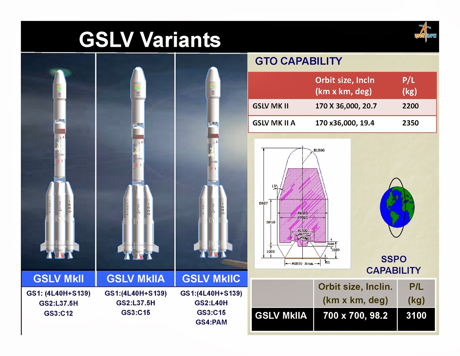
Also, I wonder what the GSLV MKIIC config is. This probably had uprated 90KN thrust CUS and 15 ton fuel , and the GS2 tank is topped up with the full 40 ton capacity. For that, I guess, the GS2 Vikas in the engine must be uprated further than at present, because, in my model, the limiting constraint on the GS2+CUS weight is the thrust in the Vikas engine as it is currently installed in the MK2.
But I guess, all the 15 ton CUS and the uprated GS2 etc will never come about. The GSLV MK3 supersedes all this and ISRO probably will not spend any more effort on the GSLV Mk2 (my guess), but direct their energies to realise the full capacity and performance latent in the GSLV MK3.
Turns, out from an ISRO Presentation posted in this Site, a 15 ton CUS stage , the difference in payload to GTO is approx JUST 150 kg , which is well within the ball park of my upper end estimate, which points to the problem with the GSLV MK2 is NOT in the CUS, but in the inefficiencies in the lower stage !
Also, I wonder what the GSLV MKIIC config is. This probably had uprated 90KN thrust CUS and 15 ton fuel , and the GS2 tank is topped up with the full 40 ton capacity. For that, I guess, the GS2 Vikas in the engine must be uprated further than at present, because, in my model, the limiting constraint on the GS2+CUS weight is the thrust in the Vikas engine as it is currently installed in the MK2.
But I guess, all the 15 ton CUS and the uprated GS2 etc will never come about. The GSLV MK3 supersedes all this and ISRO probably will not spend any more effort on the GSLV Mk2 (my guess), but direct their energies to realise the full capacity and performance latent in the GSLV MK3.
Re: GSLV-Mk III launch program/post-launch analysis
There was some reference to the place where the rocket spent stages would fall.
Here is an extract from NOTAM indicating danger zones during this launch:
A. DNG ZONE -1 IS A CIRCLE OF 10NM AROUND THE LAUNCHER
B. DNG ZONE -2 IS A RECTANGULAR AREA BOUNDED BY:
1230N 08240E 1315N 08250E 1245N 08410E
1200N 08400E
C. DNG ZONE -3 IS A RECTANGULAR AREA BOUNDED BY:
1130N 08515E 1220N 08525E 1155N 08645E
1105N 08635E
D. DNG ZONE -4 IS A RECTANGULAR AREA BOUNDED BY:
0810N 09420E 0900N 09440E 0825N 09615E
0735N 09555E
Sketch of these zones: