Military Flight Safety
Re: Military Flight Safety
Just wondering was the flight path and waypoints pre-determined ... if so I am not sure if the IAF has a process where a rescue aircraft is on standby for all flights that can quickly take to the skies once ground control thinks there is a problem.... I guess not just technology but the process and the peripheral support systems could do with some review maybe..? May be a training flight should be treated like a wartime flight with all support provided ? Of course GoI will question cost/benefit but surely it would be embarrassing if this was a conflict situation.
Re: Military Flight Safety
They are.sawant wrote:May be a training flight should be treated like a wartime flight with all support provided ?
Re: Military Flight Safety
[quote="shiv"]
If you have some useful info, kindly vomit it out pronto or else keep the noise levels down to a bare minimum.[/quote]
Well being an oldie you seem to have pretty short temper saar, Please look up or better dig up on the following issues:
Why there was no rescue beacon that was activated ?
How come the auto recovery options did not work ?
How is it that for so many years there is nothing in terms of concrete step taken to ensure that CFIT / terrain collision is ruled out in totality ; well almost as far as possible ?
What are the instrument recovery aids on most of the fleets that are existing with us ?
I have plenty to suggest and comment on but then that would not be liked....for sure ?
Just speaking my plain mind out.... saar "what ever your want; I want it more for our guys" but is it provided...
accountability and responsibility (in a expeditious manner is what is lacking). I rest my case.
Re: Military Flight Safety
Please state who manufactures crash position indicators that can be retrofitted to IAF aircraft. Weights and space requirement for fitting.saps wrote:
Why there was no rescue beacon that was activated ?
How come the auto recovery options did not work ?
How is it that for so many years there is nothing in terms of concrete step taken to ensure that CFIT / terrain collision is ruled out in totality ; well almost as far as possible ?
What are the instrument recovery aids on most of the fleets that are existing with us ?
I have plenty to suggest and comment on but then that would not be liked....for sure ?
Just speaking my plain mind out.... saar "what ever your want; I want it more for our guys" but is it provided...
accountability and responsibility (in a expeditious manner is what is lacking). I rest my case.
Please explain the limitations of terrain avoidance measures in extremely low level flying in mountainous terrain at high altitude at high speed and low visibility. Is there a 100% guarantee with the equipment? What are the limiting weather and flight conditions? Weights. Space required for installation in say MiG 21s.
What instrument recovery aids are you talking about?
Please continue to speak your mind minus the whining and/or ranting. Maybe we can all learn something from you. The answers to the above questions are unavailable to me. Do YOU know? If you do can you tell us?
Re: Military Flight Safety
The question asked above about "crash position indicators" got me curious to search about info regarding them. The best information I could find was of various (fiexed and ejectable) "ELT" - Emergency Locator Transmitters.
information about such transmitters in military aircraft is pretty sketchy. I found a 1983 pdf that stated that such locators were mandatory in all US military aircraft. But other more recent refs suggest that they are either not mandatory for military aircraft or are not placed in all military aircraft. I saw one ref that spoke of all F/A 18s being equipped with them. There was one ref that said that Italian Tornados undergoing a mid-life-upgrade got them in 2010 suggesting that they were absent before 2010.
Most refs are about portable locator beacons that people can choose to buy but all require registration.
These locator beacons are picked up by geostationary satellites dedicated to that purpose, so they have a huge application in the civil aviation sphere. It is not at all clear to me why they are not used across the board in military aircraft. Possible reasons include (my guess) the need for each beacon to be registered with a central search and rescue warning body so that there is instant identification and location. Not sure if all militaries want to share this with a civil channel in case of loss of aircraft with "special cargo" on "special missions". Of course if a military such as the US has its own private, secure search and rescue beam locator channel why not? maybe they do. But I was unable to find any such info. India of course has no such satellites and at best can hook up military aircraft to the civil channel.
The equipment itself is small and comes in two types. One is an "ejectable type" that is preferred over water. It is more reliable but can drift away from the crash site. The fixed types are apparently somewhat less reliable. They also require wiring up certain parts of the aircraft (such as ailerons) with accelerometers that detect the crash. A third problem is false alarms which could be an issue for militaries
Re: Military Flight Safety
Well it would help us if we search for SARBE beacon...if i remember i recall one of my good friend did say something long time about that...
No one flies extremely low in mountains in kind of avionics we have with our AF, its only when ac suit is fully loaded that the kind of flying i mentioned earlier could be undertaken (fighter NOE); fighter casualty from soviet ops in Afghanistan are testimony to this...but who ensures that even the basic stuff like rad alt and autopilot coupled recovery modes are serviceable ? Big questions ?
If for so many years our hard working Mig 21 have not been upgraded with basic nav stuff like VOR / ILS then who is to be held accountable ? Even a basic slow moving Cessna carries GPWS and TCAS now a days..... thinking aloud....
Everytime a Mig 21 goes down.....we start off from difficult to fly / ancient / all kind of stuff....but a comparison of basic suit of induction time (era) cockpit and todays fit would not have any difference why dont we care enough or just have a bond attitude ..... considering all the accidents of the recent past.....
In my opinion any basic airworthy GPS (even handheld set) provides enough cues about upcoming terrain and likely collission...... its like poor mans TCAS....... why has anyone from our illustrious AF not thought of integration of the same .... on all its fighters .... or even all fleets .....the screen size are just 4-5inches .... i am sure they can fit in / integrate such a small equipment in any of the tightest designed cockpit considering the amount of good it would do....
Why as mighty AF we have not been able to locate our own chap in our own territory.. unapproachable and inhospitable as it may be ...... how would you assure guys in blue about SAR in not so friendly territory ... hugely debatable....
I rest my case again.
-
Abhibhushan
- BRFite
- Posts: 210
- Joined: 28 Sep 2005 20:56
- Location: Chennai
Re: Military Flight Safety
With utter humility may I enter this very erudite discussion?
Terrain Following is not a new concept. It has been with the military of the world for more than two (three?) decades. However, There are many ways do define what one means by Terrain Following. Flying at a safe altitude while navigating with the onboard sensors matching stored maps with sensed ground pictures (which the first generation cruise missiles did) is one thing. Trying to land a loaded transport aircraft at Wallong or Along depending on sensed ground picture directing an auto pilot is another. Flying a fighter inside a valley, encountering a small patch of fog resting on the hillside and having an electronic automatic navigation system that will nonchalantly take you through this problem is quite another thing.
It all depends on accuracies of the sensors, accuracies of stored data or maps, and the agility and response of the automated control system. Only those who have actually flown in those areas under adverse weather would know the magnitude of the problem. If the accuracy is measured in small number of meters and the system depends on many sensors and actuators, then the error probability generally exceeds the available terrain clearance. That is why automatic terrain following is not practiced in the Himalayas. Not yet that is.
As far as locating a crashed aircraft is concerned, locator beacons are carried with each survival pack carried by the pilot. However, these devices are small, their battery life is limited, their power output is limited and they are limited by line of sight because they operate in the v/uhf frequencies for technical reasons. How often have you experienced loss of coverage for your mobile phone?
Last edited by Abhibhushan on 22 Oct 2011 18:06, edited 1 time in total.
Re: Military Flight Safety
Sir, what is the battery life for such devices (locator beacons) ? what would be the range in unrestricted conditions ?
perhaps pilots can be equipped with sat phones pre-programmed to send a message with location data in case of an ejection.
perhaps pilots can be equipped with sat phones pre-programmed to send a message with location data in case of an ejection.
-
Abhibhushan
- BRFite
- Posts: 210
- Joined: 28 Sep 2005 20:56
- Location: Chennai
Re: Military Flight Safety
15 to 30 km and 3 hours could be a good estimate. Anomalous propagation of signals of even 100 km have been experienced for lucky souls.Rahul M wrote:Sir, what is the battery life for such devices (locator beacons) ? what would be the range in unrestricted conditions ?
perhaps pilots can be equipped with sat phones pre-programmed to send a message with location data in case of an ejection.
Re: Military Flight Safety
If i remember correctly when installed the beacon are capable of operating a burst transmission of their location .... in normal or encrypted data burst... which are decoded and the transmitting set located with either def sat or even SAR heptr...
So why has this not happened... these sets are capable of getting activated by water / impact (g-forces) / temperature and host of other triggering mechanism... there is some deeper problem here.... just my bit...
So why has this not happened... these sets are capable of getting activated by water / impact (g-forces) / temperature and host of other triggering mechanism... there is some deeper problem here.... just my bit...
-
Abhibhushan
- BRFite
- Posts: 210
- Joined: 28 Sep 2005 20:56
- Location: Chennai
Re: Military Flight Safety
SAPS:
May I humbly suggest that the 'some deeper problem' that you are envisioning might simply be an object covered with thick vegetation and snow called the Himalayas?
I ejected once from a fighter on the Indo-Gangetic plains. A crowd in excess of 300 people gathered around me in ten minutes. The helicopter that came to pick me up after about 25 or 30 minutes could land only 300 or 400 mtrs away because of the crowd around me. (I am talking about a time of a quarter of a century before the present time.
At the same time, there are many lost aircraft of the mighty USA, lost in 1942/43 in the eastern Himalayas, that have not been traced yet despite vigorous efforts by the US and with unstinted support by India?
The Himalayas are unique. No similar environment can be found anywhere else in the world.
Re: Military Flight Safety
Sir,
with all due respect to the trauma you had to undergo almost quarter of century ago.... can you enlighten me about what all has changed since then.....have things moved on for good or still the same....
Just curious..
with all due respect to the trauma you had to undergo almost quarter of century ago.... can you enlighten me about what all has changed since then.....have things moved on for good or still the same....
Just curious..
-
Abhibhushan
- BRFite
- Posts: 210
- Joined: 28 Sep 2005 20:56
- Location: Chennai
Re: Military Flight Safety
SAPS
Nothing remains a constant. You have better weapons and platforms, smarter young men manning the forces, far better environment, much better pay packets, tougher tasks, more powerful adversaries, and so on.
The only constant might be the ignorance about the services and how to run them amongst the politicians and bureaucrats.
Re: Military Flight Safety
Transmitted to whom? Who or what picks it up. It is a satellite and that is well known. Wiki has a page on it. The older systems are not picked up instantly. The newer ones are.saps wrote:If i remember correctly when installed the beacon are capable of operating a burst transmission of their location
http://en.wikipedia.org/wiki/Distress_radiobeacon
Advantages and disadvantages of the various beacons
Analog (121.5 MHz) Beacons: SAR response to anonymous beacons can be delayed 4–6 hours, and as much as 12 hours
406 MHz (Digital) Beacons: * Resolution or response to registered beacons is very swift. SAR response can be activated within approximately 10 minutes of beacon activation (and GEOSAR detection) if distress is evident.
* Unregistered beacons can usually be responded to after only 1 LEOSAR satellite pass; after two passes, response is immediate.
Re: Military Flight Safety
And overconfident forum members who think they know what they do not know. and are accustomed to writing cryptically but aggressively in non informative posts that neither reveals knowledge nor can be accused of being empty of informationAbhibhushan wrote: The only constant might be the ignorance about the services and how to run them amongst the politicians and bureaucrats.
Re: Military Flight Safety
If you are lucky you will live longer than me. If you are unlucky I will still be posting here after you are dead. So watch how far you go with these "age" and "years" references friend. You know less about years than you imagine. And the references are irrelevant and it appears that you use that to cover up deficiencies in your own knowledge. If I am wrong please post what you know nd prove it rather than talking about someone else's age.saps wrote: with all due respect to the trauma you had to undergo almost quarter of century ago..
All that I have seen you doing is whine and curse about stuff that you have admit you don't know about in the IAF while trying to bluff your way through statements you have made about technologies that you are unable to write anything more about.
Last edited by shiv on 22 Oct 2011 19:58, edited 1 time in total.
Re: Military Flight Safety
[quote="shiv"][quote="saps"]If i remember correctly when installed the beacon are capable of operating a burst transmission of their location [/quote]
Transmitted to whom? Who or what picks it up. It is a satellite and that is well known. Wiki has a page on it. The older systems are not picked up instantly. The newer ones are.
http://en.wikipedia.org/wiki/Distress_radiobeacon
[quote]
Advantages and disadvantages of the various beacons
Analog (121.5 MHz) Beacons: SAR response to anonymous beacons can be delayed 4–6 hours, and as much as 12 hours
406 MHz (Digital) Beacons: * Resolution or response to registered beacons is very swift. SAR response can be activated within approximately 10 minutes of beacon activation (and GEOSAR detection) if distress is evident.
* Unregistered beacons can usually be responded to after only 1 LEOSAR satellite pass; after two passes, response is immediate.
[/quote][/quote]
When the eqpt is non encrypted i think it activates at National Distress signal and response from NDMC center via sat link....
when in encryption mode...the registered user gets activate with digitized coordinates of the beacon being transmitted initially and thereafter after period time intervals...
This would be most appropriate mode when being used for CSAR....and stands to logic... and there are i think geo stationary communication sat which are configured to lookout for such signals and report the same immediately...
so what has gone wrong...why no information about the brave soul even after so many days...
I agree with missing events of WWII but those were totally different days...one cannot compare those days with todays events....
Any more thoughts..
Ps...added later...getting the feeling of hostility i would turn to be lurker.....all the reference to age and years is out of sheer reverence and not any hostility..... the point is completely being missed....no one is overconfident here and not the least "ill informed"...
All the best to your speculation business when the windows are closed....last one and bit from me.
Re: Military Flight Safety
None of the references I have seen bear out this statement which could be guesswork or a bluff. Please show me one ref backing up this statement. No special encryption is offered to air forces. I am being as "humble" as you are. Your humility is so touching that I can't wait to show you some of the same humility.saps wrote: When the eqpt is non encrypted i think it activates at National Distress signal and response from NDMC center via sat link....
when in encryption mode...the registered user gets activate with digitized coordinates of the beacon being transmitted initially and thereafter after period time intervals...
Lurking and unlurking are personal choice. Except after one is dead.
Re: Military Flight Safety
^^ Technology is not an ichhamati kamdhenu to solve all problems known to mankind at the press of a button.
Any beacon/transmitter emits electromagnetic radio waves similar to light waves, and when these waves are constricted by deep valley walls, then there is no way one can detect those signals from afar.
So beacons work, but not under every and all circumstances.
Let us examine a hovercraft first. The pressure of air bouncing of the sea/land surface keeps the craft stable. But when the underlying surface is not even, say in sea state 6 and above, when the waves have high crests and deep troughs, will the air cushion maintain even pressure on areas under the craft? No. It will crash. Do hovercrafts work in hilly terrain? No.
Now Radar Altimeters function similarly, wherein the radio beams bouncing off the ground at periodic intervals are used by the flight control system to keep the aircraft at a specific height.
This works fantastic when the terrain is flat or relatively undulating.
But when the terrain is like a roller-coaster with deep valleys and high mountains, the RAM system will indicate highly variable heights. Say at T=20:02:100 overflying valley distance to ground 5000 meters. T=20:02:105 suddenly mountain appears in front distance to ground = 5 meters!!! Will the aircraft flight control in those 5 milliseconds be able to intepret the radar data, signal the hydraulics, and the hydraulics themselves to change oil pressure to move the control surfaces and the control surfaces to interact with the ambient airflow to move the 20 tonne aircraft to safety? No
Whether one sees a mobile phone GPS reading on 1. ground floor of multi-storied building 2. basement parking of multi-storied building 3. roof of multi-storied building, it will give the same reading. So poor pilot thinks he's high flying when he's crashing in the basement.
D-jinn-go solution doesnt work like Orbit White, whether for TFTA yankees or SDRE faujees.
Here is TFTA airforce planes crashing while night flying -
http://www.reuters.com/article/2008/01/ ... 0720080110
http://www.ynetnews.com/articles/0,7340 ... 17,00.html
Like the surgeons leaving gauze bandages and scapels inside a patient's stomach because they were ogling the nurses. Keep these conspiracy theories coming.
The last time an An-12 crashed in that region, the wreckage was located after 35 years. And this is a much smaller MiG29.
The personnel on the job are seasoned, and their leadership experienced with ample concern for their men. Please leave out the smart alec comments and conspiracy theories.
saps wrote:Well it would help us if we search for SARBE beacon
If one drops a flashlight/torch at the bottom of a deep (dry) well, will those on the surface be able to see the light unless they're peering directly atop the well? And when there are hundreds of such deep wells and valleys, then imagine the effort of peering into each and every well.Presenting D-Jinn-go suggested magical solution number 1 - ELT/Beacon!
Any beacon/transmitter emits electromagnetic radio waves similar to light waves, and when these waves are constricted by deep valley walls, then there is no way one can detect those signals from afar.
So beacons work, but not under every and all circumstances.
Firstly, TERCOM works for missiles, all human operated aircraft ever built use Radar Altimeters.D-Jinn-go suggested magical solution number 2 - TERCOM!!
Let us examine a hovercraft first. The pressure of air bouncing of the sea/land surface keeps the craft stable. But when the underlying surface is not even, say in sea state 6 and above, when the waves have high crests and deep troughs, will the air cushion maintain even pressure on areas under the craft? No. It will crash. Do hovercrafts work in hilly terrain? No.
Now Radar Altimeters function similarly, wherein the radio beams bouncing off the ground at periodic intervals are used by the flight control system to keep the aircraft at a specific height.
This works fantastic when the terrain is flat or relatively undulating.
But when the terrain is like a roller-coaster with deep valleys and high mountains, the RAM system will indicate highly variable heights. Say at T=20:02:100 overflying valley distance to ground 5000 meters. T=20:02:105 suddenly mountain appears in front distance to ground = 5 meters!!! Will the aircraft flight control in those 5 milliseconds be able to intepret the radar data, signal the hydraulics, and the hydraulics themselves to change oil pressure to move the control surfaces and the control surfaces to interact with the ambient airflow to move the 20 tonne aircraft to safety? No
SAR gives a moving map image in all weather. Imagine you are standing in an locomotive cabin with a all weather video camera. You see Basanti tied to the tracks. Unfortunately locomotives, like aircraft, travel fast and even if you take corrective action like braking, it might not always be possible not to run over Basanti. Similarly, even with a terrain image, when one is flying a fast moving aircraft, it might not be possible to take corrective action in time.D-Jinn-go suggested magical solution number 2a - SAR!!
Same issue with digital 3-D maps. You're driving a car with a map in hand and a pothole comes in front while you're intently reading the map, even if the sexy voice of iPhone Map App says "pothole ahead", will you be able to change direction in time? No. Because you & car have something called reaction time that might not be sufficient.D-Jinn-go suggested magical solution number 2b - 3-D Digital Maps!!
saps wrote:In my opinion any basic airworthy GPS (even handheld set) provides enough cues about upcoming terrain and likely collission...... its like poor mans TCAS....... why has anyone from our illustrious AF not thought of integration of the same .... on all its fighters .... or even all fleets .....the screen size are just 4-5inches .... i am sure they can fit in / integrate such a small equipment in any of the tightest designed cockpit considering the amount of good it would do....
GPS gives the latitude and longitude. So one knows, on a particular spherical surface, what is his position relative to a reference point. But does GPS indicate with accuracy whether he is 500 meters above or below that spherical surface? No.D-Jinn-go suggested magical solution number 3 - GPS!!!
Whether one sees a mobile phone GPS reading on 1. ground floor of multi-storied building 2. basement parking of multi-storied building 3. roof of multi-storied building, it will give the same reading. So poor pilot thinks he's high flying when he's crashing in the basement.
D-jinn-go solution doesnt work like Orbit White, whether for TFTA yankees or SDRE faujees.
Here is TFTA airforce planes crashing while night flying -
http://www.reuters.com/article/2008/01/ ... 0720080110
http://www.ynetnews.com/articles/0,7340 ... 17,00.html
Ah, the maintenance personnel are incompetent. Or the planes arent equipped. D-jinn-go X-Ray vision able to see the plane innards to find the gizmos not present and perceive the antar-atma of the incompetent maintenance personnel to reach the conclusion that they didnt service the gizmos.saps wrote:but who ensures that even the basic stuff like rad alt and autopilot coupled recovery modes are serviceable ? Big questions ?If for so many years our hard working Mig 21 have not been upgraded with basic nav stuff like VOR / ILS then who is to be held accountable ? Even a basic slow moving Cessna carries GPWS and TCAS now a days..... thinking aloud....
Like the surgeons leaving gauze bandages and scapels inside a patient's stomach because they were ogling the nurses. Keep these conspiracy theories coming.
Why did the world's TFTA'd country couldnt find a rich millionnaire with plane equipped with TFTA'd gizmos for ONE YEAR? http://en.wikipedia.org/wiki/Steve_Fossett and http://upload.wikimedia.org/wikipedia/c ... le1443.jpgsaps wrote:Why as mighty AF we have not been able to locate our own chap in our own territory.. unapproachable and inhospitable as it may be ...... how would you assure guys in blue about SAR in not so friendly territory ... hugely debatable....
The last time an An-12 crashed in that region, the wreckage was located after 35 years. And this is a much smaller MiG29.
The personnel on the job are seasoned, and their leadership experienced with ample concern for their men. Please leave out the smart alec comments and conspiracy theories.
Re: Military Flight Safety
Well, all is well understood..but if we live with "all is well" syndrome....guess no lessons would be derived...
like the D-jinn-go analogy though....
It may just be true..
Wish everything is as you say.....
"The personnel on the job are seasoned, and their leadership experienced with ample concern for their men"
like the D-jinn-go analogy though....
It may just be true..
Wish everything is as you say.....
"The personnel on the job are seasoned, and their leadership experienced with ample concern for their men"
Re: Military Flight Safety
Really? Does the pilot read comics too?vasy_ray wrote:Elaborating on the INS approach, the locus of the flight can be traced in real time and superimposed on the pre-built terrain maps, based on the flight's current motion parameters (roll, yaw, pitch, velocity vector), make a predictive path that could be traversed for the next 5 secs, this prediction gets revised every moment, this is nothing new, we know the Tejas is fly by wire, with the flight computer doing the actual flying while the pilot is really navigating with the flight computer doing similar 'sensing'
And the momentum of a 20 ton plane multiplied by 800 km/h speed is reduced to zero and it hovers in mid-air like a Harriervasy_ray wrote:At any point the predictive path meets the terrain map, the autopilot will not let the pilot make that move
Yes, and the plane instantly moves in any direction! Move over Mithun-da, planes have any-direction-thrust-vectoring with nozzles in the nose!vasy_ray wrote:now at the same time the navigational software will provide alternate paths the Pilot could safely take
All this can be displayed on the Kindle reader too, he needn’t divert his attention from the comic bookvasy_ray wrote:the pilot sees all this on his HUD
How can the poor SDRE flight computer instantaneously compute and predict the flight path every time the D-jinn-go makes a Mithun-da type dance move? FWIW, even TFTA flight computers can’t keep up with Mithun-da.vasy_ray wrote:it would not have turned into a full roll inadvertently had the autopilot limited the pilot's input based on predictive path and internally stored terrain maps
Can you imagine the storage requirements of such data? Even today, storing such data requires a bloody datacenter with rows of servers. Try making this weight and volume fly.vasy_ray wrote:if the pilot sees the prebuilt terrain map on his HUD relative to his position even when he is traversing the valleys in the night, his situational awareness is enhanced greatly.
Where do they get depth information?vasy_ray wrote:SAR pods supplement with all weather radar imagery and should be carrying depth information just because they rely on radio echo
Ah, do these transport planes generate enough electricity to power the PESA radars?vasy_ray wrote:once AESA radars make way to the fighters, one could take the current PESA radars onto the transport fleet assuming these fighter radars can support SAR or ground mapping mode
What will be programmed into the autopilot. Super AESA senses terrain ahead. It covers entire FoV of azimuth ±60º elevation ±60º. What does poor SDRE computer do? Fly up, down, left or right, only mountain? Confusion all the way.vasy_ray wrote:hopefully all of these aircrafts have auto pilot so instead of just verbal warnings in the cockpit from the TERPROM or like system, another software layer that gives feedback directly to the auto pilot by setting safe limits is needed
So many big words - TERPROM (Terrain Profile Matching) / Ground Proximity Warning System (GPWS) / Predictive Ground Collision Avoidance System (PGCAS) / Obstruction Warning and Cueing (OWC)
http://en.wikipedia.org/wiki/Ground_pro ... ing_systemTraditional GPWS does have a blind spot. Since it can only gather data from directly below the aircraft, it must predict future terrain features. If there is a dramatic change in terrain, such as a steep slope, GPWS will not detect the aircraft closure rate until it is too late for evasive action
This works only in commercial flights where flight paths are constant, and not military flights, where flight paths are variable. Also, commercial flights can carry the weight and volume of related storage, not small fighters.In the late 1990s improvements were made and the system was renamed "Enhanced Ground Proximity Warning System" (EGPWS/TAWS). The system was now combined with a worldwide digital terrain database and relies on Global Positioning System (GPS) technology. On-board computers compared its current location with a database of the Earth's terrain. The Terrain Display now gave pilots a visual orientation to high and low points nearby the aircraft.
Last edited by tsarkar on 22 Oct 2011 20:58, edited 1 time in total.
-
Eric Leiderman
- BRFite
- Posts: 364
- Joined: 26 Nov 2010 08:56
Re: Military Flight Safety
The information below is strictly from a commercial marine point of view , However the applications have similarities namely search and rescue
EPIRB acrynom for Emergency position indicating radio beacon. Fequency high microwave,satellite based, satellite in a Geo SYnchronous orbit. ie 360,000 miles above equator(if I remember right) The satellite remains fixed in relation to the rotation of the earth.
The EPIRB transponder is samll light and cheap, shaped like a cylinder it is approx 1.5 inch dia and 2 feet length , weight under 3 kg
Battery life under storage conditions 3-5 years, battery life while transmitting 2-3 days Info transmitted vessels name, vessels details,
Last GPS fix. and a whole lot more. It floats free when vessel sinks. Battery activated in salt water. World wide coverage
Radar beacon very effective as a homing device. transmits usually in x band and shows up on radar screen as a visual homing beacon, giving range and bearing (2 dimensional no altitude)
application immediate local coverage
Correcting some of the posts above
GPS is 3 dimensional depending on the number of satellites available to itareate the fix.
Above 3 satellites on the fix and it will give u altitude.
Following is slightly OT but interesting
When a vessel transits the panama canal she is climbing up a hill using a series of locks.
The GPS then gives one the altitude of the vessel. Also when initializing a GPS system one of the parameters that needs to be fed in is height abve sea level of the GPS antenna. All the above will be available on brochures of marine electronic manafacturers
how (if at all) these manifest themselfs in an aviation (military) application I do not know
Re: Military Flight Safety
No one is saying all is well. The ire and sarcasm is directed towards those who're trivializing the issue and believe the solution is a few key taps away.saps wrote:Well, all is well understood..but if we live with "all is well" syndrome....guess no lessons would be derived...
The issues on hand are complex and people spend lifetimes trying to find solutions, often without success.
Sometimes, even every possible human effort taken isnt suffcient. Like the An-12 crash in 1968.
A coursemate who flew with 17 squadron and his parents had accompanied Ajay Ahuja & his family to Vaishodevi a few months before Kargil. It was the last vacation Ajay had taken. He still ponders wasnt he in the air that fateful day and what he could have possibly done to save his fellow flyer that day.
Re: Military Flight Safety
A hand held air worthy GPS can and does show terrain clearance data within the selected scale and the tolerances given in the setup...which normally starts from hundred of feet to all the way to couple of hundred of kilometers... since it does contain digital database.... may not be accurate to wpn delivery however good enough for terrain avoidance.
even in Himalayan terrain this works...at the operating speeds of fighter class of aircraft TILL the GPS locks.
If such eqpt can be integrated.... then may be future story could be different and it doesn't cost much.
Lets turn this constructive discussion by looking at option of having such an eqpt making a positive impact on near obsolete systems onboard....
-
Virupaksha
- BR Mainsite Crew
- Posts: 3110
- Joined: 28 Jun 2007 06:36
Re: Military Flight Safety
the newbie confidence graph is sooo true.
-
prithvi
Re: Military Flight Safety
just as high as the grumpiness of veterans... instead of vague sarcasms and direct mocking a clear and forthright explanation is an easy way to calm things..is not that what "seniors" are for?Virupaksha wrote:the newbie confidence graph is sooo true.
Re: Military Flight Safety
Saps,
You are getting your terminology and understanding of all these systems mixed up. GPS is Global Positioning System, simply put, you have a receiver which uses information transmitted by sats to fix your position. Given the fact that GPS (civilian grade) comes with its own error, you'll have several tens of mtrs of error about where your exact location is. What you need to do is combine this with a GIS (Geographical Information System), if you intend to use this GPS data to give you more than cursory positional data. Plus the GIS data needs to be available for the terrain you are flying over - easier said than done, has every inch of India been mapped? Not really. Next, you need an onboard height sensing device which basically says, OK, GPS data+INS gives me this, I should be here, GIS says this is the terrain below, radalt says my height is this, feed this info to the autopilot to fly my aircraft at such a height (safety factor included) so that I don't crash into the terrain.
Now as you can see, each of these sensors comes with its own error margin, plus the GIS database needs to be cent per cent accurate (or as close as possible) and on top of it, your autopilot needs to be able to compensate for any meteorological or other conditions (eg gusts of wind etc) and also, be "quick enough" to make sure that the aircraft reacts in time to control input from the AP "brain".
All this is easier said than done.
Abhibhushan may correct me If I am wrong - but AFAIK, the TERPROM developed by Atlantic Inertial - now Goodrich (and which is flying today on most fighters of the US and 4+G WW - eg Rafale, Typhoon - and its on offer to India as well) - basically works reliably when the terrain is not such a problem and the GIS data is available to a high level of accuracy.
http://www.atlanticinertial.com/uploads ... ng-low.pdf
Basically, if you are flying over the plains & the occasional hillock or hill comes into picture, the system + Autopilot + onboard sensors can work fine. But the lower you go, the faster you go, the risks increase.
Now considering the Himalayas, a fast moving fighter, and a GIS db which (to my knowledge) is basically still WIP (I do know the IA/IAF are always updating their maps and DB but I don't know whether the entire terrain + contours have been mapped to the accuracy desired) - and I seriously think even tech can only go so far.
Add to this, that in this case, it was night.
Plus, even TERPROM is entirely passive in its database reliant mode- problem is you need to, AFAIK, keep updating your GIS DB. For instance, if the opponent were to deploy a bunch of balloon barrage systems & the system was not updated accordingly, it could be an issue. So an AF would continue to insist that its pilots train extensively via manual training & not just rely on automated systems.
If you couple it to onboard sensors - well, you lose the passive advantage - and frankly, apart from AESA, air superiority fighters with mechanical antenna's cannot interleave modes to do both terrain following, obstruction detection etc & also look out for air to air threats. The MiG-29 is an air superiority fighter. Its raison de etre is to hunt down other aircraft. Its radar & WCS (at least in the original version) don't offer multirole capability. In the Upgrade as well, while the cockpit is likely to be NVG capable and it does get multirole capability - its system will not allow for interleaving of modes.
Your statements about GPS & height etc cannot even apply in this case, because frankly, Milgrade GPS is not available to us & even if it were, it comes with a height issue. Assuming the height is one thing, but the risk remains because of the error differential.
Fighter training is dangerous because of the wide variety of conditions involved. Tech has not evolved to the state that pilots can let it dominate the situation and only provide limited input. Which is why hand-eye coordination, and quick reflexes are so important to pilots. Flying around valleys, flying low, well - these are exactly why their business is so dangerous.
Re: Military Flight Safety
It was a hunch and TERPROM is not from my back pocket, its real and it is with many fighters like stated in the last
post
the point of having terrain maps is, one is not doing ranging calculations just relative to his position and direction, a fighter has a known flight envelope which its auto pilot can support, at any instant the fighter's state is determined by a point in that space, draw out a small part of that space which is feasible in say 5 secs of flight time given the current state, using that bounded space determine the physical 3D space where the flight can be, this 3D space will have to be calculated every few milliseconds which is incremental, now superimposing this dynamic map onto the subset of prebuilt terrain maps based on the current location, it gives a truncated 3D space which is also dynamic and as long as the latter's size doesn't shrink below error thresholds, the pilot always has a safe navigation path, put this feed back into the autopilot, the small space in the static flight envelope has an additional boundary (?) which the auto pilot if given authority will not let the pilot cross
a fighter may not have preset navigation path, however the pilot still has to fly with the limitations of the flight, integrating the terrain maps only adds to these limitations for the safety of the pilot. Thats the general idea, the maths behind this may not be easy, so solutions aren't few key strokes away, I hope that makes you happy.
for example, FBW in Tejas uses lookup tables to keep the plane in the safe flight envelope, currently testing is expanding on that, IF this lookup table is made dynamic since the terrain map changes with location, you have terrain avoidance
to drill into you that your sarcasm is misplaced, saying Tejas uses a lookup table doesn't in anyway reduce the years of testing involved to get to that data and making it a dynamic table is not a chutki
Anyways, IAF is getting the terrain avoidance systems into its fleet via upgrades, like Abhibushan sir says, there are shades of sophistication to the same technology and the main limitation is with the accuracy of the sensors, I hope its a matter of time before even the Himalayas can be 'conquered'
Re: Military Flight Safety
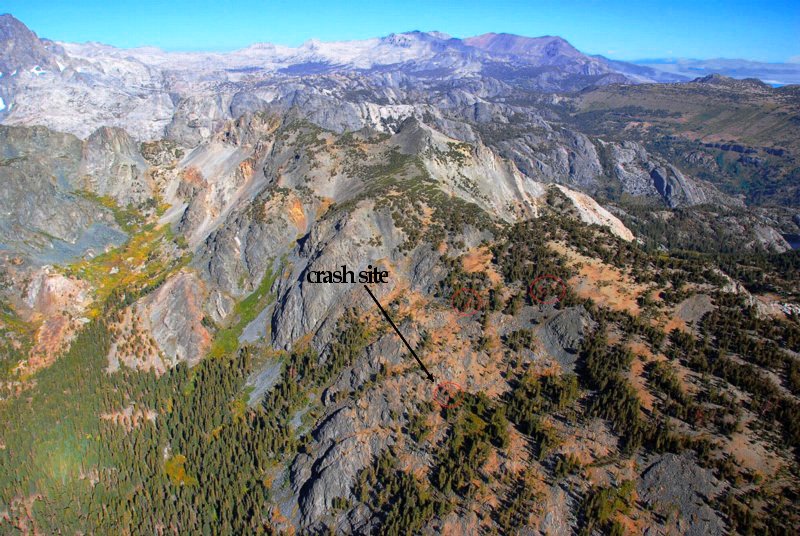
Jai, thank you for your amazing pics & Abhibhushan, for your insight.
Re: Military Flight Safety
Vasu, if I may, context matters. What you are missing in this otherwise acccurate post is that this was a MiG-29. MiG-29s have to train to shoot down low flying planes. Not become low fliers themselves (unless on a strike mission) where they can rely on an AP + GIS sort of system like TERPROM. You are speaking of low flying vis a vis a strike pilot who can choose from a variety of routes en route to a target, trying to bypass zones of AD, and having the system do the heavy lifting.vasu_ray wrote:It was a hunch and TERPROM is not from my back pocket, its real and it is with many fighters like stated in the last
post
the point of having terrain maps is, one is not doing ranging calculations just relative to his position and direction, a fighter has a known flight envelope which its auto pilot can support, at any instant the fighter's state is determined by a point in that space, draw out a small part of that space which is feasible in say 5 secs of flight time given the current state, using that bounded space determine the physical 3D space where the flight can be, this 3D space will have to be calculated every few milliseconds which is incremental, now superimposing this dynamic map onto the subset of prebuilt terrain maps based on the current location, it gives a truncated 3D space which is also dynamic and as long as the latter's size doesn't shrink below error thresholds, the pilot always has a safe navigation path, put this feed back into the autopilot, the small space in the static flight envelope has an additional boundary (?) which the auto pilot if given authority will not let the pilot cross
a fighter may not have preset navigation path, however the pilot still has to fly with the limitations of the flight, integrating the terrain maps only adds to these limitations for the safety of the pilot. Thats the general idea, the maths behind this may not be easy, so solutions aren't few key strokes away, I hope that makes you happy.
for example, FBW in Tejas uses lookup tables to keep the plane in the safe flight envelope, currently testing is expanding on that, IF this lookup table is made dynamic since the terrain map changes with location, you have terrain avoidance
to drill into you that your sarcasm is misplaced, saying Tejas uses a lookup table doesn't in anyway reduce the years of testing involved to get to that data and making it a dynamic table is not a chutki
Anyways, IAF is getting the terrain avoidance systems into its fleet via upgrades, like Abhibushan sir says, there are shades of sophistication to the same technology and the main limitation is with the accuracy of the sensors, I hope its a matter of time before even the Himalayas can be 'conquered'
But the fighter has to shoot down this threat.
IOW, if a low flying threat comes in, a MiG-29 pilot has to train to shoot it down, which may mean, depending upon the situation, that he has to fly low himself. Because there is no system in the world - yet - or planned - that can automatically detect such a low flying, fast, TF target, and then fly the fighter in a low flying mode, to automatically track that target with the pilot just acting as an observer, and shoot that target down.
Please look up what happened in the Iraq conflict (first one) when a F-111 (if my memory is correct) was credited with a fighter as a "kill" because the latter went into the ground trying to keep up, to shoot it down. The F-111 has TFR, and AP system which worked well in the (relatively) flat plains of the Iraqi deserts
Last edited by Karan M on 22 Oct 2011 23:41, edited 1 time in total.
Re: Military Flight Safety
AFAIK - no IAF fighter has TERPROM yet, though it is on offer. I recall AI reps explaining the latest version at Aero India '09. Both MMRCA contenders have it.vasu_ray wrote:Ok, TERPROM is the keyword for 'blind flying' and wiki says these aircraft of relevance to us have it,
M2K, Harrier, Jaguar, Typhoon, Hawk, C-130 and C-17
unfortunately IAF versions may not have it yet
M2k's latest upgrade might include it
Indian Jaguars do not have it, on the latest Jaguar upgrade,
http://indiadefenceonline.com/1453/hal- ... r-upgrade/
"Navigational accuracy will be enhanced through the addition of an INS-RLG (SAGEM Sigma 95) and a Terrain Reference Navigation System (TRNS) is likely to be added. Another striking incorporation is of the new Open Systems Architecture Mission Computer (OSAMC) system which will carry out the mission computing and display functions. An ELTA-built airborne self-protection jammer and an indigenous radar warning receiver (RWR) will be installed."
however on its own, it wouldn't have helped the last crash since it was the pilot losing control
Hawk might have it since its a recent acquisition
C-130, wiki page says,
"The Indian Air Force purchased six C-130J-30s in early 2008 at a cost of up to US$1.059 billion[27] for its special
operations forces in a package deal with the US government under its Foreign Military Sales (FMS) program. India has options to buy six more of these aircraft.[28] The Indian government decided not to sign the Communications Interoperability and Security Memorandum of Agreement (CISMOA), which resulted in the exclusion of high precision GPS and other sensitive equipment. The IAF may add similar equipment to the aircraft after delivery.[29] In October 2011, India announced its intent to exercise the option for the six additional aircraft, following the credible performance of the C-130J in the 2011 Sikkim earthquake relief operations.[30]"
But it is of relevance only on a strike mission. Not when intercepting low flying threats. There the pilot comes into play.
This is the Phazatron radar cued to the AP+INS/MC etc, but again, for a strike mission.On the Mig-29 upgrade,
"it also adds terrain following mode, and ground target acquisition including high-resolution modes. "
hopefully all of these aircrafts have auto pilot so instead of just verbal warnings in the cockpit from the TERPROM or like system, another software layer that gives feedback directly to the auto pilot by setting safe limits is needed,
work for DARE?
btw, the technology for TERPROM was available a decade before
BTW, apparently my memory was not playing tricks on me.
http://www.defensemedianetwork.com/stor ... ert-storm/
Point is, IAF will train its pilots to intercept low flying a/c to avoid this situation, which in turn means risks are high even in training.On Jan. 16, before Desert Storm actually began, an unarmed 42nd ECS EF-111A crew accomplished the first aerial kill of the war. The Sparkvark was attacked by an Iraqi Mirage fighter while flying at night near the Saudi/Iraq border. To try to defeat the Iraqi fighter, the ’Vark pilot descended at very high speed to minimum altitude using the jet’s terrain-following radar (TFR). While trying to follow the F-111, which excelled at low-altitude, high-speed flight, the unfortunate Iraqi pilot slammed into the ground.
In this case, only tech aid - since it was night - that could have helped were NVGs, and if it was foggy or weather was bad - all bets are off even so.
One can only hope that a miracle occurs and the pilot survives
Re: Military Flight Safety
I am amazed at man's arrogance thinking he'll better mother nature.vasu_ray wrote:I hope its a matter of time before even the Himalayas can be 'conquered'
Ofcourse, tapping fingers dont know that every harbour in the world are dredged regularly to create shipping channels because underwater currents and tides completely change the sea floor on a regular basis, underwater volcanoes create new Islands and ridgeline, etc, that is barely understood by hydrographers and geographers. There is a Hydrographic Survey of India and a fleet of survey ships working constantly, but even they, to paraphrase Newton's words, "are picking pebbles on the seashore of knowledge".
So when a survey ship reports that ocean current X in location Y is factor Z, it is valid at that point of time. There is still degree of uncertainity for Captain A of Ship B launching his BrahMos from location Y that his ship might drift off course and the missile might overshoot/undershoot his land target.
Same goes for the Himalayas. Every monsoon changes courses of rivers, there are minor earthquakes that keep changing topography, snowfall alters heights of peaks, and yet jokers think the Himalayas can be mapped to the nth degree.
What makes you think the so called lookup table is geo-spatial data?vasu_ray wrote:for example, FBW in Tejas uses lookup tables to keep the plane in the safe flight envelope, currently testing is expanding on that, IF this lookup table is made dynamic since the terrain map changes with location, you have terrain avoidance
What makes you think the flight computer is so powerful as to 1. determine aircraft position every second and 2. retrieve geo-spatial data every second 3. cross-check every second of aircraft-data with geo-spatial data (when the aircraft could have gone any way based on Pilot's judgment in a combat situation) 4. Predict flight path for 5 seconds in any possible way based on the Pilot's judgment 5. Cross check predicted path with stored data 6. Control the plane over-riding the pilot. All in real time
For all this wonderful Nobel prize winning theory, no aircraft and no computing power on earth can implement this in reality on a real time basis. Because flight computers cannot handle that degree of processing nor storage available to store the copious volumes of data.vasu_ray wrote:the point of having terrain maps is, one is not doing ranging calculations just relative to his position and direction, a fighter has a known flight envelope which its auto pilot can support, at any instant the fighter's state is determined by a point in that space, draw out a small part of that space which is feasible in say 5 secs of flight time given the current state, using that bounded space determine the physical 3D space where the flight can be, this 3D space will have to be calculated every few milliseconds which is incremental, now superimposing this dynamic map onto the subset of prebuilt terrain maps based on the current location, it gives a truncated 3D space which is also dynamic and as long as the latter's size doesn't shrink below error thresholds, the pilot always has a safe navigation path, put this feed back into the autopilot, the small space in the static flight envelope has an additional boundary (?) which the auto pilot if given authority will not let the pilot cross
I conclude by stating that aircraft do have some very limited predictability and safety capability made possible by the very best human effort towards technology so far, but that capability is still miniscule to the actual scope of flying, combat or otherwise.
Last edited by tsarkar on 23 Oct 2011 00:47, edited 1 time in total.
Re: Military Flight Safety
GPS does provide the altitude but the main problem why it can't be relied upon for terrain avoidance in particular (and military/commercial aviation in general) is the reference system used by it. GPS uses WGS84 ellipsoid as the reference base for calculation of altitude, which does not, coincides with the sea level at all places and has no relevance with AGL.
http://bhgc.wikidot.com/tutorials:diffe ... s-altitude
Barometric altimeters show pressure altitude, which uses standard sea level pressure as the reference point and assumes the atmosphere to be ideal (i.e. uniform throughout) which is not the case. But still it is used as primary altitude reference because flying characteristics (mach speed) of an aeroplane primarily depends upon pressure/temperature of atmosphere and will remain constant for aircrafts flying in relatively close proximity. Only a radar altimeter can provide the true altitude for terrain avoidance.
Cheers....
Re: Military Flight Safety
Karan, for the MMRCA's TERPROM, why is it applicable only for strike missions? its not just meant for preplanned flight paths, why can't it be a navigation aid in the chase flight? the pilot is doing the flying, its only when he is in the danger of imminent terrain collision that the system gives verbal warnings
and an improvement would be when in cases where verbal warnings do not give sufficient response time to the pilot
attempts to correct are directed through the auto pilot
and an improvement would be when in cases where verbal warnings do not give sufficient response time to the pilot
attempts to correct are directed through the auto pilot
Re: Military Flight Safety
Place yourself in the pilots shoes and imagine the situation. You are chasing a target down a valley, just as in those pics posted by Jai, and tell me - is that Terprom going to be a help or a hindrance? Its likely to be squawking every second, warning of an imminent danger. My point is very simple - when you are flying a pre-programmed route, with the AP doing the heavy lifting - the TERPROM is useful to assist pilot intervention in those cases where the AP lags or some unforeseen hazard comes into play. When you are chasing that very same target @ speed - its no longer as useful. It just does not offer you the same amount of leeway. Of course, depends on the situation - if it was the Iraqi chasing the F111 over the flat desert - sure, TERPROM may be useful but not so much so when you have sheer cliffs on either side, and you are in a twisting valley where the "floor" height keeps changing as well. My point is that for an air superiority fighter, eyeball MK1 and reflexes MK1 are what count the most.
Re: Military Flight Safety
The IAF has more flying experience than anyone else in the world in such areas, and more crashing experience as well. No one outside that group really know what they are up against. Do you have any information to say that this will make military flying in the Himalayas 100% safe? I am not asking this as a rhetorical question to trip you up. But how much do you know about the sort of practical operational flying required in the Himalayas by the IAF and how much do you know about the details and limitations of TERPROM?vasu_ray wrote:Karan, for the MMRCA's TERPROM, why is it applicable only for strike missions? its not just meant for preplanned flight paths, why can't it be a navigation aid in the chase flight? the pilot is doing the flying, its only when he is in the danger of imminent terrain collision that the system gives verbal warnings
and an improvement would be when in cases where verbal warnings do not give sufficient response time to the pilot
attempts to correct are directed through the auto pilot
Are you familiar with the actual geography in some areas of the Himalayan valleys and the applicability of TERPROM in special situations? If so could you please post.
Last edited by shiv on 23 Oct 2011 06:49, edited 1 time in total.
Re: Military Flight Safety
Answering my own question
TERPROM limitations - from a Goodrich systems promotional pdf
Goodrich says:
http://www.skybrary.aero/index.php/GPWS/TAWS
Two problems arise from this
1. The limitations of radar altimetry
2. The need to have a map of the terrain in one's TERPROM database.
TERPROM is, after all, TERrain PROfile Matching. The question of "unmapped obstacles" poses the following questions:
Radar altimeters that look down will show wild fluctuation in mountain terrain. terrain following radars emt signals that anti-aircraft weapons can home into. Detailed mountain terrain maps may not be available for every inch of mountain on say the Chinese side of the Himalayas. Battle damage or technical malfunction may render the radar altimeter ineffective. Unkil may switch off mil GPS for SDREs during war.
What all this means is not that TERPROM is useless. It only means that pilots have to learn to fly without it for serious operational effectiveness. That is when accidents are more likely to occur.
TERPROM limitations - from a Goodrich systems promotional pdf
TERPROM is, after all, TERrain PROfile Matching. The question of "unmapped obstacles" poses the following question:Merging TERPROM’s terrain and obstruction map information with
data from active sensors such as infrared, optical, laser and millimeter wave radar can enhance
safety in low-level operations. The TERPROM system can use information from these active
sensor systems to identify and record unmapped obstacles or enemy weapon positions.
However, active systems have their limitations and may be highly detectable by the enemy. A pilot can elect to use these sensors, or not, allowing the TERPROM system to operate passively
and remain undetectable.
Goodrich says:
Here is some more infoThe system references the actual terrain over which the aircraft is flying, drawn
from the aircraft’s radar altimeter and inertial navigation system combined with a digital terrain
database, to give highly accurate terrain-referenced navigation and situational awareness - even
in areas where GPS is not available.
http://www.skybrary.aero/index.php/GPWS/TAWS
A ground proximity warning system (GPWS) is a safety net that provides automatically a timely and distinctive warning to the flight crew when the aeroplane is in potentially hazardous proximity to the earth’s surface.
<snip>
However, basic GPWS suffers from a serious limitation: because the radio altimeter does not look ahead, it is unable to predict a sudden change in terrain, for example, when meeting steeply rising ground.
In 1991, Honeywell introduced their Enhanced Ground Proximity Warning System (EGPWS) which was developed in order to overcome the above limitation. This system combines accurate positional knowledge (normally determined from GPS) with a precise three dimensional map of the terrain, to look ahead of the aircraft as well as downwards. This generates warnings to the pilot if certain parameters are breached
Two problems arise from this
1. The limitations of radar altimetry
2. The need to have a map of the terrain in one's TERPROM database.
TERPROM is, after all, TERrain PROfile Matching. The question of "unmapped obstacles" poses the following questions:
Radar altimeters that look down will show wild fluctuation in mountain terrain. terrain following radars emt signals that anti-aircraft weapons can home into. Detailed mountain terrain maps may not be available for every inch of mountain on say the Chinese side of the Himalayas. Battle damage or technical malfunction may render the radar altimeter ineffective. Unkil may switch off mil GPS for SDREs during war.
What all this means is not that TERPROM is useless. It only means that pilots have to learn to fly without it for serious operational effectiveness. That is when accidents are more likely to occur.
Re: Military Flight Safety
sir,
I think that the discussion has drifted well beyond where it started.....could we prevent such occurrences. Now ppl are mixed up with fast low flying with full authority to systems in Himalayan terrain.
My humble submission after reading so many wise post was only this......in the present set of avionics and systems could there have been some thing done or worked upon which would prevent a CFIT especially in hills. Remember mission was in night so remote possibility of ac flying NOE over those hills; no airforce would do it and its amply brought out in discussion.
About Mil grade GPS....please look for Garmin 296 / 496 upwards series.....the small display does give warning approaching terrain in hills (even in Himalayan hills)....may be i will upload a video of the same next time. GPS does provide 3D data and depending on no of channel that are on offer...better the resolution of data.....JUST that it does not have any failure wx or for that matter warning about lock break so there is the problem.
About prediction of path in combat scenario....well no manned fighter is or can do it....the day it is done you can be rest assured all us lesser mortals would see UCAV's fighting the star war...but if i am correct the control surface response as well other feedback loops work in milli sec only human has not gone below 1 sec reaction time.
If i recollect correctly digital data work had commenced quite some time ago and should be completed by now with all UPDATED (within tolerances) digital maps available with our armed forces; on this point even GARMIN issues out updates to its data base on a regular basis.
The kind of chase as is shown in movies in hills i dont think happens in real life unless both pilots would know the hill and valleys+obstruction like the back of their hand....unlikely to happen with one in home and other in hostile territory.
About database for GPS...well that datum can be changed and i recollect someone mentioning that instead of WGS84 it is suggested that IND database for better accuracy should be used.....so its variable depending on where you are aiming to deploy/employ.
About changing topography of himalayas.....what changes most is the lay of terrain....snow clad....barren....green.....in transition......so the same terrain and features look grossly different when negotiating at faster speed. I dont think there would be such great changes which would require massive changes in the digital database unless one is flying in glacier areas where the topography changes in any case very rapidly due to land slide very often to be of any help.
May i suggest no hostility and more civility.....after all most of us are learning....and not preaching...
Re: Military Flight Safety
Well I hope we can all stick to that. Note that some of the hostility started with the following post that YOU made earlier containing all the elements that you now feel is OT and unnecessary. You spoke of TERPROM controlled hands off low level Himalayan flying and made an ignorant critical sarcastic comment about the IAF.saps wrote: Now ppl are mixed up with fast low flying with full authority to systems in Himalayan terrain.
<snip>
May i suggest no hostility and more civility.....after all most of us are learning....and not preaching...
We must all learn. We criticise after we have learnt and find that we know more than the experts. If we are learning how does one become competent enough to be critical of the experts?saps wrote: Modern generation aircrafts have moved on from TERCOM to TERPROM and some of them can do a ultra Low level flying in best of himalayan hills with pilot being hands off. Do you think that IAF is even thinking about what all it "MUST HAVE" to ensure that mission accomplishment is as important as safety of crew+machine.