Thanks Shiv-ji
So the Chinese pretty much know whenever any IAF Plane attains a certain height from any airbase in the NE
The thing is, there is no comparable high altitude Radar site on the Indian side.
There are, but the IAF needs a lot more !
Military Installations of China, Pakistan & other countries on Google Earth
Re: Military Installations of China, Pakistan & other countries on Google Earth
But below a certain height they can see nothingGagan wrote:Thanks Shiv-ji
So the Chinese pretty much know whenever any IAF Plane attains a certain height from any airbase in the NE
Re: Military Installations of China, Pakistan & other countries on Google Earth
Wonder how effective the Jammers will be if facing 5 different radars in that area.
Flying low between the hills, in the valleys will be a very dangerous operation and in bad weather it will be impossible
Those radars will need to be shut down before any festivities begin
There are a few up north near J&K too
Flying low between the hills, in the valleys will be a very dangerous operation and in bad weather it will be impossible
Those radars will need to be shut down before any festivities begin
There are a few up north near J&K too
Re: Military Installations of China, Pakistan & other countries on Google Earth
Radars will always be among the first targets. Flying itself is dangerous and the Air Force does low flying all the time. But "low" in Himalayas will be 20-25000 feet. Planes will take off at sea level and climb to that altitude to even get across the Himalayas. That said they will have routes that are blind to Chinese radars - flying in the shadow of specific mountain features. Radars close to the border can receive spl forces love
Re: Military Installations of China, Pakistan & other countries on Google Earth
finally its a cat and mouse game between radars/planes/jammers/missiles.... superior tactics/training/electronics/weapons will win the day !!
Re: Military Installations of China, Pakistan & other countries on Google Earth
Possible S-300 site east of Gonggar Airbase near Lahsa, Tibet
29°17'41.16"N, 90°58'5.52"E
29°17'41.16"N, 90°58'5.52"E
Re: Military Installations of China, Pakistan & other countries on Google Earth
Looking at the areas near J&K:
1. There is the missile site near Saitulla / Xiatulla, just north of the Karakoram pass, that I posted earlier.
36°19'14.49"N, 78° 1'5.27"E
Airbases:
1.Kashghar has an airport / airforce detachment: 39°32'23.69"N, 76° 1'14.91"E
Radar Site just south of the airport: 39°23'56.41"N, 76° 0'17.62"E
2. Radar site covering Saitulla (there are actually 2 sites). This is one, the other is in Hotan airbase
37°53'36.51"N, 77°19'36.26"E
3. Hotan airbase with numerous Nanchang Q-5, ground attack aircraft
37° 2'29.10"N, 79°51'39.71"E
Radar station in the base: 37° 2'41.84"N, 79°51'43.09"E
The closest fighter equipped Indian airbase is Leh. Maybe IAF can enlarge Thoise and station fighter there?
4. Rutog Military Base: This was the main base where the chinese attack on to J&K was staged out of. India had due intel that there was heavy troop build up. The IAF was overlying and taking pictures, but the billis in dilli was twiddling their thumbs and asking the IAF to do nothing except take pictures.
33°22'59.81"N, 79°43'55.61"E
The IAF could have easily bombed the crap out of the chinese eating chowmein here back in '62
5. As a result, the chinese attacked: Rezang La: 33°29'56.62"N, 78°52'29.96"E
33°25'16.80"N, 78°52'3.31"E
Maj Shaitan Singh and his brave lads from 13 Kumaon fought to the last bullet, the last man in the hills here. Maj Shaitan Singh was decorated with the PVC
Rezang La Memorial: 33°31'7.64"N, 78°43'51.23"E
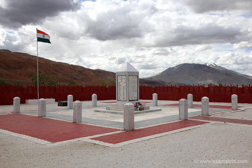
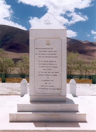

The inscription reads:

6. Srijap: Where Maj Dhan Singh Thapa was decorated with the PVC
33°44'39.24"N, 78°51'53.24"E
I was thinking of marking out the points where Indian soldiers were decorated with the PVCs
7. Chinese Motor Boat site on the Pagong-Tso:
33°46'16.15"N, 79° 4'16.65"E
8. Kunshaxiang Airbase: With a 5 Km runway.
After the airbase was set up, the chinese felt the need to make their presence felt. So they launched a few helos into J&K and the soldiers came and painted Chinese letters in Red paint, claiming it was their territory near the Demchock area
32° 6'34.00"N, 80° 3'26.93"E
9. Ngari Dam, on a rivulet that ends up in the Indus
32°31'24.70"N, 80° 9'26.71"E
Ngari is expanding rapidly. There is a solar power plant there too now. Need to keep an eye on this town.
There is I believe a possible radar site in Aksai Chin or close by, but I haven't been able to locate it. It is very time consuming to go sector by sector and locate it. Also hampered by old images on Google Earth / Digital Globe. If people want to join in, that would be great !
1. There is the missile site near Saitulla / Xiatulla, just north of the Karakoram pass, that I posted earlier.
36°19'14.49"N, 78° 1'5.27"E
Airbases:
1.Kashghar has an airport / airforce detachment: 39°32'23.69"N, 76° 1'14.91"E
Radar Site just south of the airport: 39°23'56.41"N, 76° 0'17.62"E
2. Radar site covering Saitulla (there are actually 2 sites). This is one, the other is in Hotan airbase
37°53'36.51"N, 77°19'36.26"E
3. Hotan airbase with numerous Nanchang Q-5, ground attack aircraft
37° 2'29.10"N, 79°51'39.71"E
Radar station in the base: 37° 2'41.84"N, 79°51'43.09"E
The closest fighter equipped Indian airbase is Leh. Maybe IAF can enlarge Thoise and station fighter there?
4. Rutog Military Base: This was the main base where the chinese attack on to J&K was staged out of. India had due intel that there was heavy troop build up. The IAF was overlying and taking pictures, but the billis in dilli was twiddling their thumbs and asking the IAF to do nothing except take pictures.
33°22'59.81"N, 79°43'55.61"E
The IAF could have easily bombed the crap out of the chinese eating chowmein here back in '62
5. As a result, the chinese attacked: Rezang La: 33°29'56.62"N, 78°52'29.96"E
33°25'16.80"N, 78°52'3.31"E
Maj Shaitan Singh and his brave lads from 13 Kumaon fought to the last bullet, the last man in the hills here. Maj Shaitan Singh was decorated with the PVC
Rezang La Memorial: 33°31'7.64"N, 78°43'51.23"E
The inscription reads:
6. Srijap: Where Maj Dhan Singh Thapa was decorated with the PVC
33°44'39.24"N, 78°51'53.24"E
I was thinking of marking out the points where Indian soldiers were decorated with the PVCs
7. Chinese Motor Boat site on the Pagong-Tso:
33°46'16.15"N, 79° 4'16.65"E
8. Kunshaxiang Airbase: With a 5 Km runway.
After the airbase was set up, the chinese felt the need to make their presence felt. So they launched a few helos into J&K and the soldiers came and painted Chinese letters in Red paint, claiming it was their territory near the Demchock area
32° 6'34.00"N, 80° 3'26.93"E
9. Ngari Dam, on a rivulet that ends up in the Indus
32°31'24.70"N, 80° 9'26.71"E
Ngari is expanding rapidly. There is a solar power plant there too now. Need to keep an eye on this town.
There is I believe a possible radar site in Aksai Chin or close by, but I haven't been able to locate it. It is very time consuming to go sector by sector and locate it. Also hampered by old images on Google Earth / Digital Globe. If people want to join in, that would be great !
Re: Military Installations of China, Pakistan & other countries on Google Earth
Also there are more airstrips being built by the chinese inside Tibet, close to the LAC and the Indo-Tibet border, but the images are not updated by google earth.
Re: Military Installations of China, Pakistan & other countries on Google Earth
The easiest way to locate an installation is to "follow the road"
No critical big stationary installation is built unless there is a good road.
Now there are mobile radar sites and mobile SAM sites one will see from time to time, but they will have gone, when google updates their images the next time. So no sense posting those. At one point I had located a dozen such SAM and Radar sites in Pakistan, but they all disappeared in the next update and have probably relocated.
Re: Military Installations of China, Pakistan & other countries on Google Earth
Absolutely. +1Gagan wrote:The easiest way to locate an installation is to "follow the road"
No critical big stationary installation is built unless there is a good road.
Re: Military Installations of China, Pakistan & other countries on Google Earth
Name: Shamsi Airfield (Bhandari Airstrip)
Type: Airstrip first leased to UAE for hunting wildlife, then to USA for military operations.
Location: Washuk District, Balochistan, Pakistan.
Coordinates: 27°50'51.00"N 65° 9'35.63"E
Occupants: It was used by USA as a base for Predator drones from 2001 till 2011. Leased by UAE from 1992-2001. Now presumably controlled by Pakistan FC.
Comments: Shamsi Airfield caught my interest in particular due to the fact that no new imagery is available since after 2014. Another point of interest is it's use by USA from 2001 till 2011 as a base for armed Predator drones which were used in counter terrorism attacks in nearby areas. USA vacated this base after frictions arising due to American raids inside Pakistani territory leading to deaths of 24 Paki armymen. This base for previously under control of UAE which used it for falconry trips.
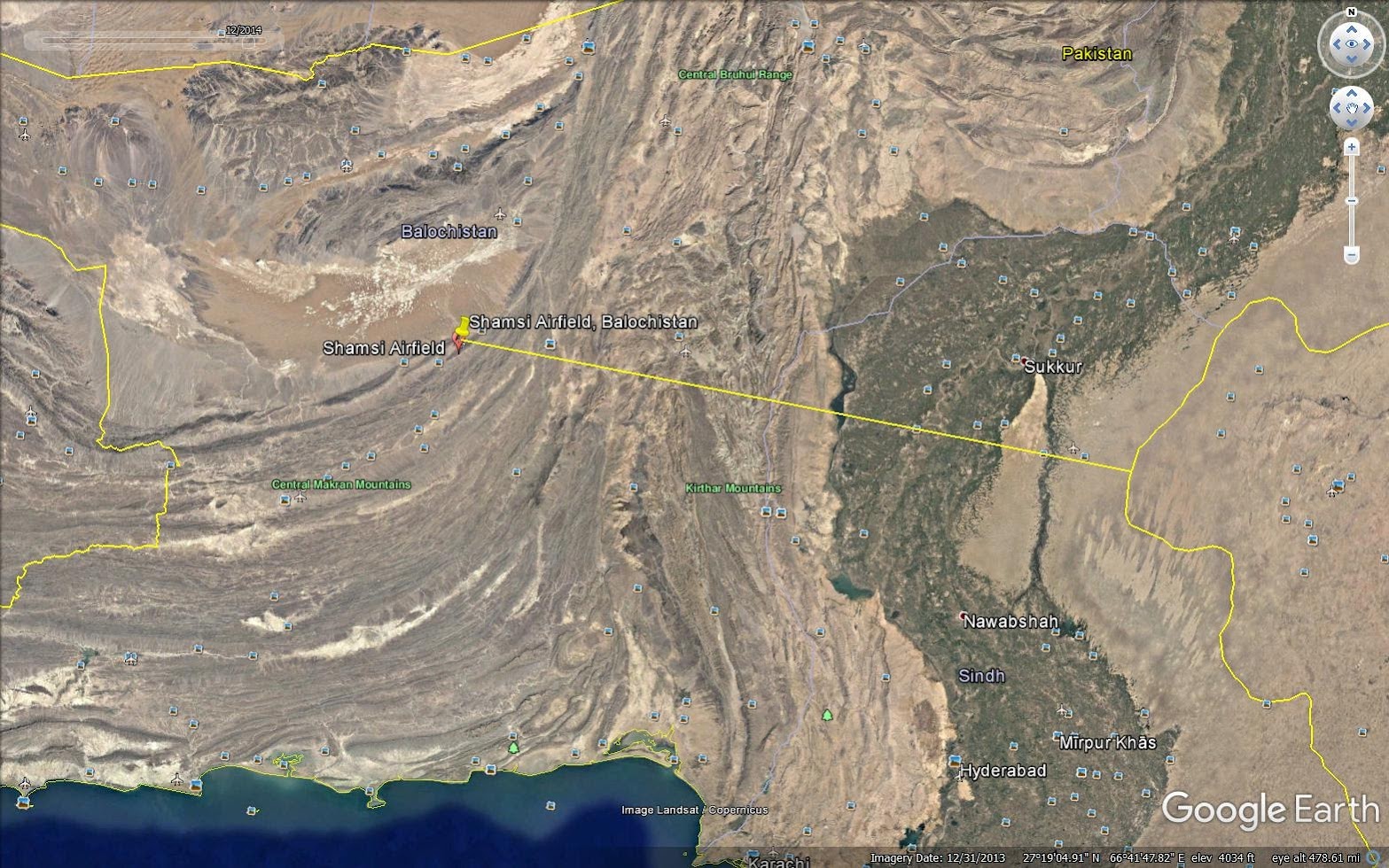
Shamsi Airfield, 440 km from IB

Shamsi Airfield, airstrip length 2.3 km

Transport airplane on ground

Structures on way to airstrip from the main road

Look like shipping containers

3 American Predator drones in 2004

New hangars and buildings constructed after the previous image was taken

Before 2004, there was only a single small hangar

Unidentified structure on right was constructed after 2007
Unidentified structure on right was constructed after 2007

A Mi-17 helicopter and Paki personnel after USA's evacuation of the base.

Pakistani and American personnel near a drone
Type: Airstrip first leased to UAE for hunting wildlife, then to USA for military operations.
Location: Washuk District, Balochistan, Pakistan.
Coordinates: 27°50'51.00"N 65° 9'35.63"E
Occupants: It was used by USA as a base for Predator drones from 2001 till 2011. Leased by UAE from 1992-2001. Now presumably controlled by Pakistan FC.
Comments: Shamsi Airfield caught my interest in particular due to the fact that no new imagery is available since after 2014. Another point of interest is it's use by USA from 2001 till 2011 as a base for armed Predator drones which were used in counter terrorism attacks in nearby areas. USA vacated this base after frictions arising due to American raids inside Pakistani territory leading to deaths of 24 Paki armymen. This base for previously under control of UAE which used it for falconry trips.
Shamsi Airfield, 440 km from IB
Shamsi Airfield, airstrip length 2.3 km
Transport airplane on ground
Structures on way to airstrip from the main road
Look like shipping containers
3 American Predator drones in 2004
New hangars and buildings constructed after the previous image was taken
Before 2004, there was only a single small hangar
Unidentified structure on right was constructed after 2007
Unidentified structure on right was constructed after 2007
A Mi-17 helicopter and Paki personnel after USA's evacuation of the base.
Pakistani and American personnel near a drone
Re: Military Installations of China, Pakistan & other countries on Google Earth
Need help to find Arty Positions in POK
Like this: 34°15'41.70"N, 73°48'33.38"E
34°19'11.73"N, 73°40'56.06"E
They are 7-15 odd Kms from the LOC.
They will be alongside a road, mostly on hill tops, with usually a clear view of the LOC
Look for a circular gun emplacement, and the resolution should be good enough to see the gun inside.
One can see support tents, maybe communication towers sometimes.
They are all meant to provide covering fire for terrorists to be infiltrated into India
Re: Military Installations of China, Pakistan & other countries on Google Earth
images not visible. best to upload to a blog and then link from there. else photos get deleted over time.
Re: Military Installations of China, Pakistan & other countries on Google Earth
This is strange. Can you see images on this link ?Rahul M wrote:images not visible. best to upload to a blog and then link from there. else photos get deleted over time.
http://jjamwal.in/yayavar/military-inst ... -pakistan/
Re: Military Installations of China, Pakistan & other countries on Google Earth
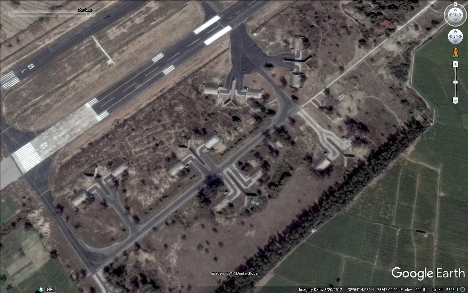
Name: Chandhar Airbase
Type: Pakistan Air Force operated airfield, no civilian use.
Location: Punjab, Pakistan.
Coordinates: 32° 4'38.20"N 73°47'23.65"E
Occupants: PAF
Airstrip Length: 2.4 km
Comments: There is very little information about Chandhar airbase available in open sources. It's about 77 km away from international border and seems to be military installation for use only during war time as a way of dispersing aircraft. There are some aircraft shelters, basic underground storage bunkers but limited support infrastructure. It's surrounded by farms on all sides and shows very little signs of activity, construction and changes
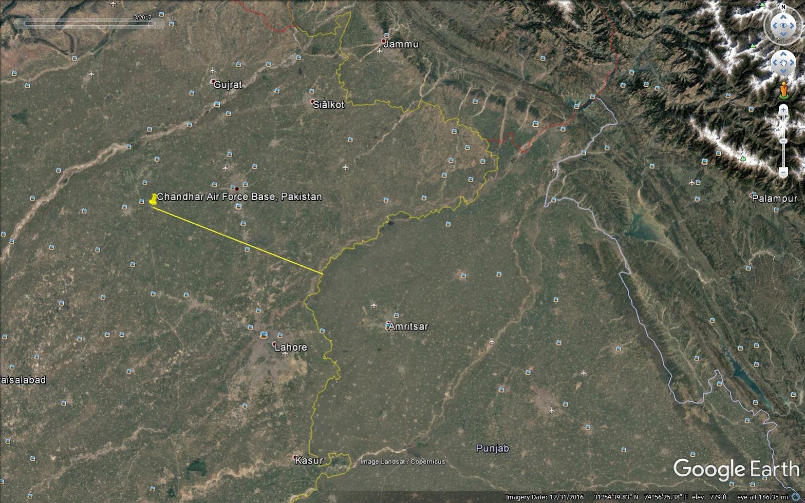
Chandhar airbase, Distance from border 77 km
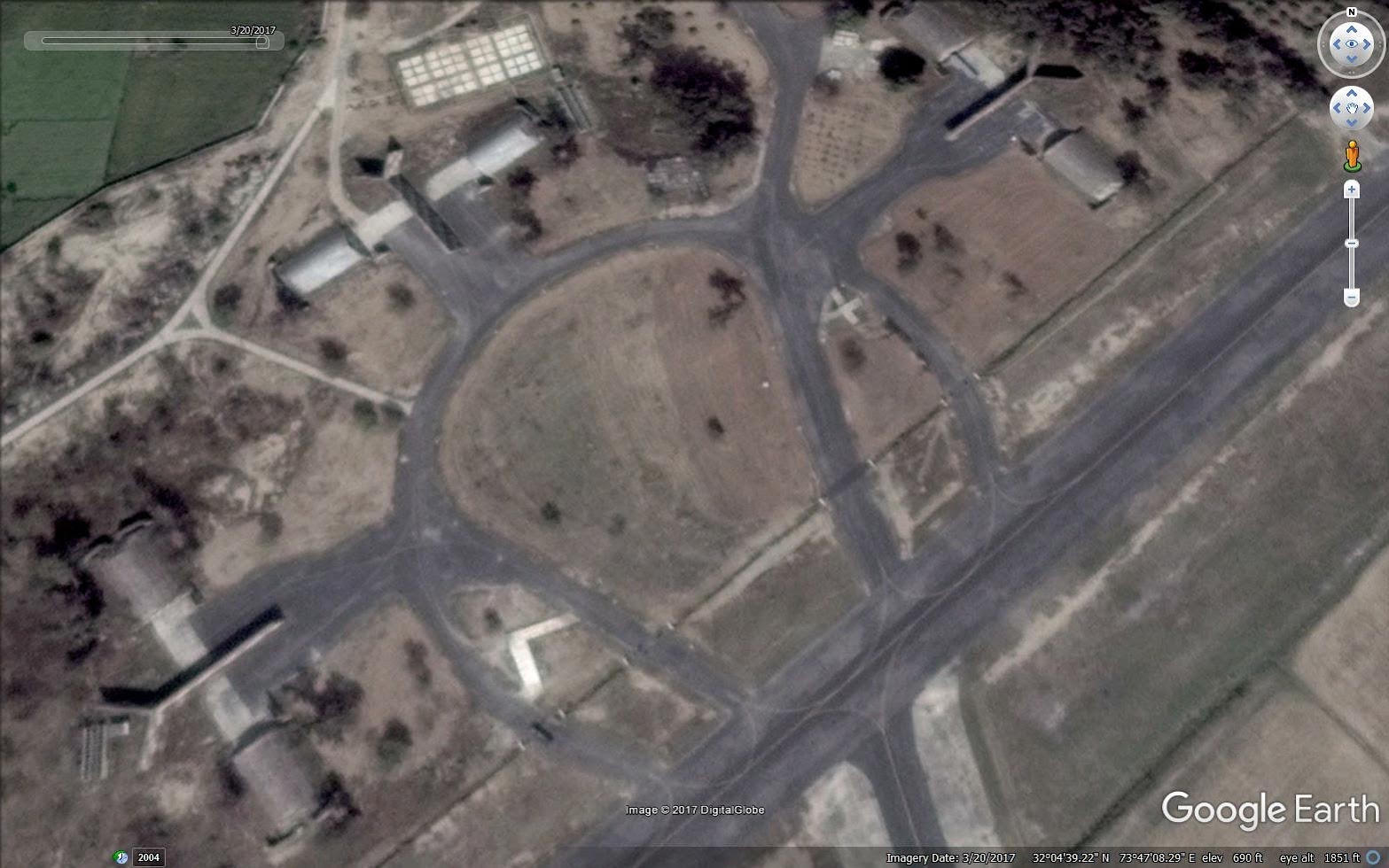
Aircraft shelters 1
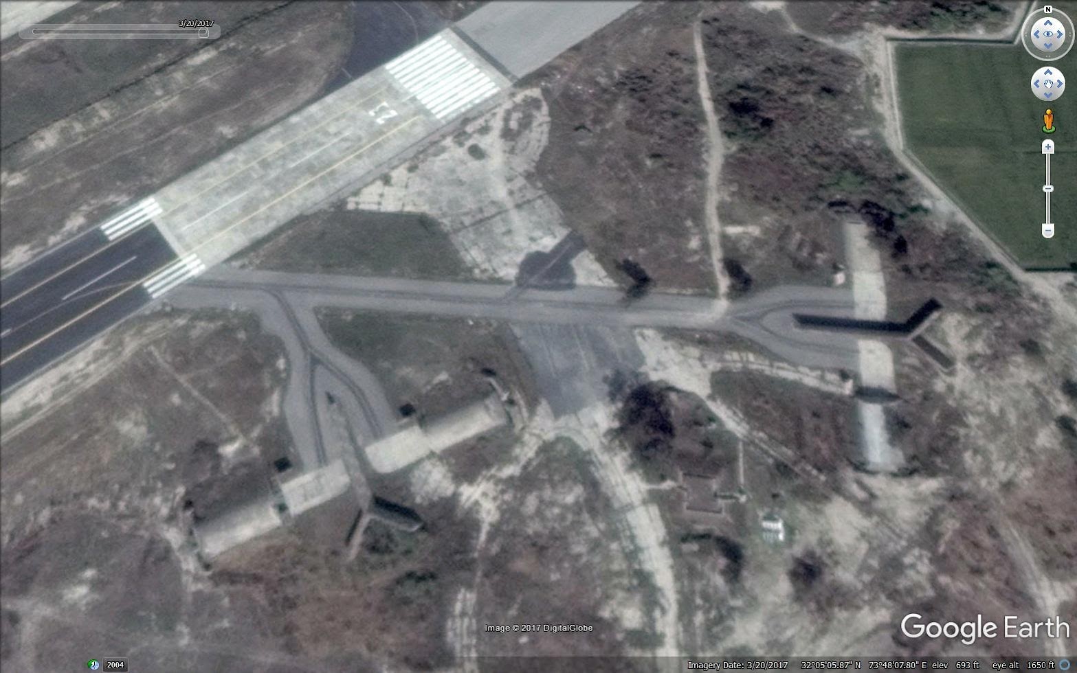
Aircraft shelters 2
Aircraft shelters 3
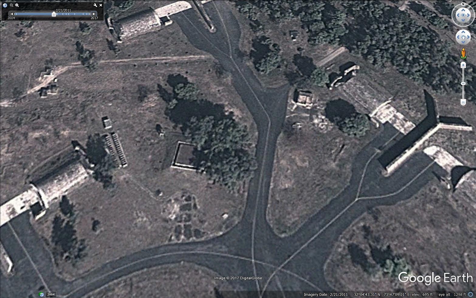
Hardened bunker

Possible underground bunker and air defence site
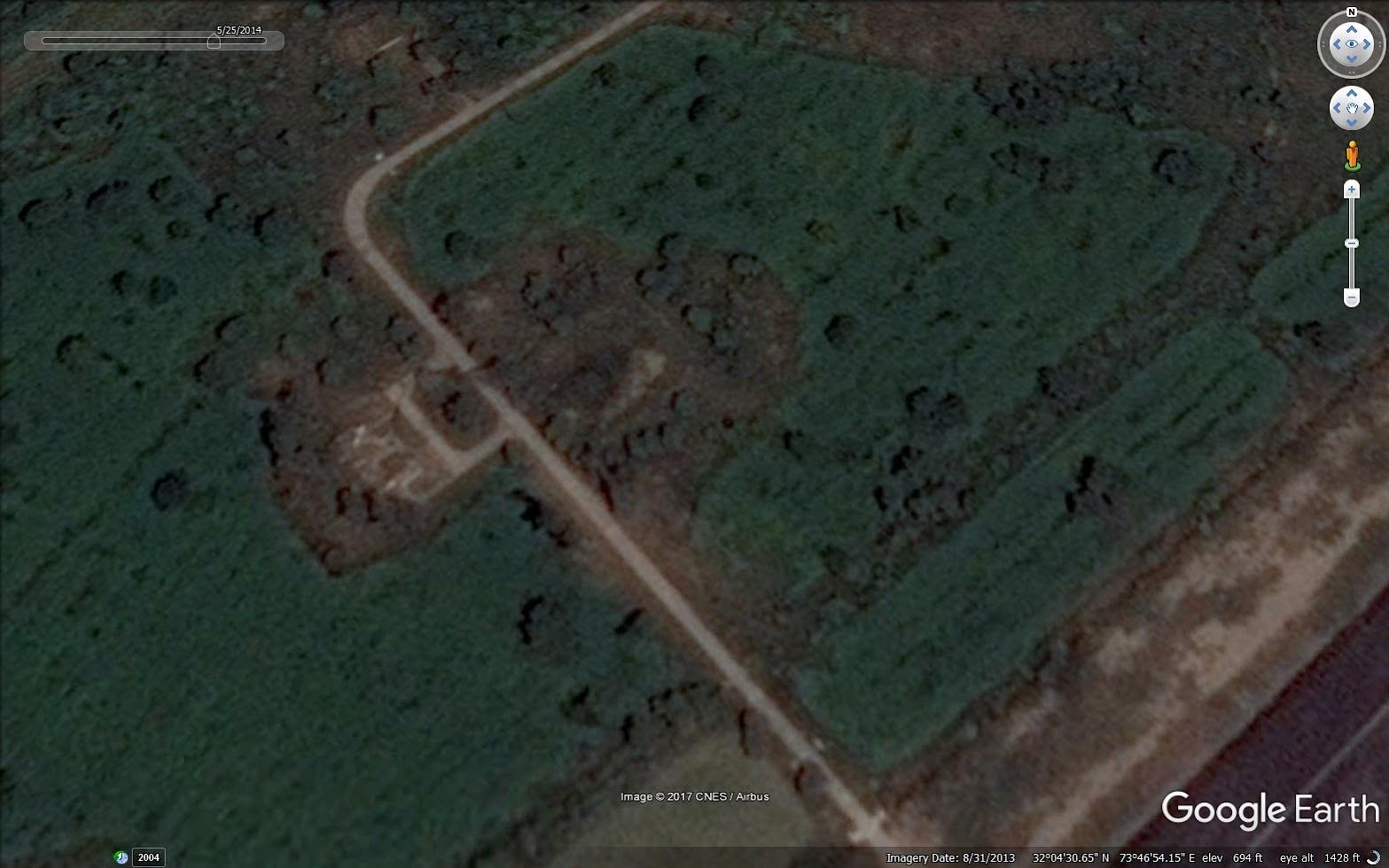
Unidentified (possible AD site)
Type: Pakistan Air Force operated airfield, no civilian use.
Location: Punjab, Pakistan.
Coordinates: 32° 4'38.20"N 73°47'23.65"E
Occupants: PAF
Airstrip Length: 2.4 km
Comments: There is very little information about Chandhar airbase available in open sources. It's about 77 km away from international border and seems to be military installation for use only during war time as a way of dispersing aircraft. There are some aircraft shelters, basic underground storage bunkers but limited support infrastructure. It's surrounded by farms on all sides and shows very little signs of activity, construction and changes
Chandhar airbase, Distance from border 77 km
Aircraft shelters 1
Aircraft shelters 2
Aircraft shelters 3
Hardened bunker
Possible underground bunker and air defence site
Unidentified (possible AD site)
Re: Military Installations of China, Pakistan & other countries on Google Earth
Chander is a Satellite Airbase according to FAS, used for emergency aircraft landing & recovery. It is quite close to the IB with India, and Pakistan has no hope of successfully protecting this airbase. What is clear from the sat pictures, is that Pakistan doesn't even try to protect this installation, beyond some very basic measures.
This below is from FAS: The info must be dated by now:
Major Operational Bases are fully functional bases from which aircraft operate during peacetime.
Forward Operational Bases are active during peacetime and become fully operational during wartime.
Satellite bases are used for emergency landing and recovery of aircraft during both peacetime and wartime.
Code: Select all
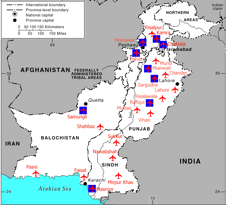
[b]Airbase		Facility	Command	Wing	Squadron	Aircraft 	AC #[/b]
PAF Bhagtanwala			sat
PAF Chaklala				MOB
										No.35 (Composite Air Transport) Wing
										No. 6 Sqn	C-130	14
										No.12 Sqn	B707, Falcon, F-27	6
										No.41 Sqn	Cessna, Aero, Beach 	3
										No.455 Sqn	Crotale SAM
										No.??? Sqn	HQ-2B SAM
PAF Chander				sat
PAF Chuk Jhumra		   sat
PAF Faisal					MOB		Southern Air Commander HQ
PAF Gwadar				sat
PAF Kamra [Minhas]		 	MOB		Northern
										No.33 (Fighter/Multi-Role) Wing
										No.14 Sqn	F-7P	~24
										No.15 Sqn	F-6, FT-6	~24
PAF Kohat					sat
PAF Lahore	 			FOB
PAF Masroor	 	 		MOB		Southern
										No 32 (Fighter Ground Attack) Wing
										No. 2 Sqn	F-7P	~24
										No. 7 Sqn	Mirage 5PA, III	24+45
										No. 8 Sqn	Mirage 5PA, III	24+45
										No.22 Sqn	Mirage 5PA, IIIDP	14 + 2
										No.84 Sqn	Alouette III	2
										No.453 Sqn	Crotale SAM
										No.??? Sqn	HQ-2B SAM
PAF Mianwali			MOB
										No. 37 (Combat Training) Wing
										No. 1 Sqn	FT-5	25
										No.19 Sqn	F-7P	~24
										No.25 Sqn	F-7 & FT-7	~24
										No.86 Sqn	Alouette III	2
PAF Mirpur Khas				FOB
PAF Multan			FOB
PAF Murid					FOB
PAF Nawabshah				FOB
PAF Ormara				sat
PAF Pasni					FOB
PAF Peshawar		MOB		Northern Air Command HQ
										No.36 (Tactical Attack) Wing
										No.16 Sqn	A-5	25
										No.26 Sqn	A-5	24
										No.81 Sqn	Alouette III	2
PAF Rafiqui		MOB		Central
										No. 34 (Fighter) Wing
										No. 5 Sqn	Mirage IIIEP/RP	30
										No.18 Sqn	F-7P	~24
										No.20 Sqn	F-7P	~24
										No.83 Sqn	Alouette III	2
PAF Rahim Yar Khan			sat
PAF Rajanpur				sat
PAF Risalewala Faisalabad		FOB
PAF Risalpur	MOB
PAF Samungli Quetta		MOB		Southern
										No. 31 (Fighter) Wing
										No.17 Sqn	F-6, F-7P, FT-6	~24
										No.23 Sqn	F-6 	~24
										No.85 Sqn	Alouette III	2
PAF Sargodha			MOB		Central Air Command, HQ
										No.38 (Multi-Role) Wing
										No. 9 Sqn	F-16A	16
										No.11 Sqn	F-16 A/B	16
										No.24 Sqn	Falcon 20 F/G	2
										No.82 Sqn	Alouette III	2
										Combat School	F-7	~24
										Combat School	Mirage 5PA
PAF Shahbaz Jacobabad		FOB
PAF Sindhri				sat
PAF Sukkur				FOB
PAF Talhar					FOB
PAF Vihari					FOB
Re: Military Installations of China, Pakistan & other countries on Google Earth
From FAS:
Two units operating the Chinese-built A-5 [No. 16 Sqn and No. 26 Sqn], an aircraft believed to be a leading candidate for the aerial delivery of nuclear weapons, were reportedly stationed at PAF Masroor in early 1998. By late 1999 they had reportedly been re-deployed to PAF Peshawar.
Re: Military Installations of China, Pakistan & other countries on Google Earth
There are a few airstrips in POK which are not in this list above:
Skardu: 35°20'40.11"N, 75°32'41.82"E
Gilgit airstrip: Where all their ATR 42 and 72 turboprop aircraft keep meeting their 72s, and they butcher goats to ward off evil spirits. 35°55'8.19"N, 74°20'10.91"E
Chilas airstrip: Mostly defunct. Pakistan does not have any money to keep it going. 35°25'34.83"N, 74° 5'15.11"E
Rawlakot: Close to Hajipir pass, has a small pocket sized airstrip. 33°51'0.37"N, 73°47'55.26"E
Muzzafarabad: POKs capital, and main terror training base. 34°20'14.23"N, 73°30'33.99"E
Apart from this, there are small-medium sized airstrips in Chitral and Swat, both in KP, mostly useable by ATR Truboprops and Helos
Re: Military Installations of China, Pakistan & other countries on Google Earth
Skardu: has pens for some 8 aircraft, nicely clustered together  (They're asking for it IMHO). They mostly fly C-130s to supply troops, and sometimes move troops here.
They deploy JF-17, Mirages and F-16s here every summer just to keep the base operational. Usually no winter deployments.
They deploy JF-17, Mirages and F-16s here every summer just to keep the base operational. Usually no winter deployments.
Re: Military Installations of China, Pakistan & other countries on Google Earth
There is news that the Chinese are deploying J-10 fighters and H-6 Bombers in Hotan Air base:
The Hotan airbase has numerous Nanchang Q-5, ground attack aircraft
37° 2'29.10"N, 79°51'39.71"E
Radar station in the base: 37° 2'41.84"N, 79°51'43.09"E
Other nearby Radar sites
1.Kashghar has an airport / airforce detachment: 39°32'23.69"N, 76° 1'14.91"E
Radar Site just south of the airport: 39°23'56.41"N, 76° 0'17.62"E
2. Radar site covering Saitulla (there are actually 2 sites). This is one, the other is in Hotan airbase
37°53'36.51"N, 77°19'36.26"E
Re: Military Installations of China, Pakistan & other countries on Google Earth
Xinjiang air bases with elevation and distance from LAC at Aksai Chin. Hotan/Khotan is closest at 270 kmGagan wrote:There is news that the Chinese are deploying J-10 fighters and H-6 Bombers in Hotan Air base:
The Hotan airbase has numerous Nanchang Q-5, ground attack aircraft
37° 2'29.10"N, 79°51'39.71"E
Radar station in the base: 37° 2'41.84"N, 79°51'43.09"E
Other nearby Radar sites
1.Kashghar has an airport / airforce detachment: 39°32'23.69"N, 76° 1'14.91"E
Radar Site just south of the airport: 39°23'56.41"N, 76° 0'17.62"E
2. Radar site covering Saitulla (there are actually 2 sites). This is one, the other is in Hotan airbase
37°53'36.51"N, 77°19'36.26"E

Re: Military Installations of China, Pakistan & other countries on Google Earth
Shiv ji
Very nice video and analysis
There is a military airfield with a 5 Km runway at Kunshaxiang
32° 6'4.58"N, 80° 3'7.47"E
There are I believe several airstrips in tibet along the indo-tibet and nepal-tibet border, along the G-219 highway, but google has not updated the images yet. (The images are from Nov 2014)
Rutog is a big mil base, and has helipads, but no airstrips.
Ngari, was supposed to get an airstrip. There is ample land and geography to do so.
Further, Dangxiong 30°28'59.43"N, 91° 3'34.23"E has an airstrip, which can be upgraded to an airbase
Re: Military Installations of China, Pakistan & other countries on Google Earth
Linzhi Airport - also called the Nyingchi Kang Ko International, is CAT III capable, and can handle flights 24x7
Re: Military Installations of China, Pakistan & other countries on Google Earth
The tibet railway needs to be looked at too.
A friend of mine traveled on it. The trip is a week long journey, from the chinese mainland to Lahsa. They have oxygen supply on the train
Heavy equipment will be moved in only via this railway.
This recent chinese deployment of tanks also probably was brought in using this, then moved to the final destination via road.
The railway is now being extended to Nepal, which means it will be able to deploy the chinese military from their main bases around Lhasa and beyond all the way upto the Indo-Tibet and Nepal-Tibet borders.
The railway and its extension beyond Lhasa is fairly easy to follow on the current google map updates.
Re: Military Installations of China, Pakistan & other countries on Google Earth
Kanwa.org is talking about Chinese missile regiment deployments in Korla, Xinjiang.
On evaluating Korla (which is a bombing range cum missile test complex)
Bombing range is here: 41°38'30.70"N, 86°20'42.50"E. One can see numerous ground markings to indicate the targets.
I see a LPAR - a Large Phased Array Radar site at : 41°38'27.96"N, 86°14'13.28"E
The radar is directed southwards towards India - to keep track of any ballistic missile/Aircraft launches over the Tibetan plateau.
Also check out FAS: https://fas.org/nuke/guide/china/facility/lpar.htm.
The info on FAS is really dated.
A second radar site is located here: 41°39'24.21"N, 86° 8'33.93"E
A military airport with covered shelters for fighters at 41°36'49.24"N, 86° 8'18.91"E
Just north of Korla is another military airfield Uxxaktal at 42°11'7.80"N, 87°10'40.96"E
One can see Mig-21s / J-7s and one Xian H-6 bomber based here.
It is possible, that the chinese have moved these planes around and to forward deployment to Hotan.
Re: Military Installations of China, Pakistan & other countries on Google Earth
I wonder where the Chinese tanks are deployed at?
So far no source available on the media, but I would assume in the areas around Ladakh - Chushul / Demchock or DBO. These are the only border areas where the terrain is flat enough to allow tanks to travel. Every other border area is bounded by some of the highest mountains and steep hills.
I would say between Ngari and Kunshangxiang
Re: Military Installations of China, Pakistan & other countries on Google Earth
Most likely in Xinjiang. Look for them there.Gagan wrote:I wonder where the Chinese tanks are deployed at?
So far no source available on the media, but I would assume in the areas around Ladakh - Chushul / Demchock or DBO. These are the only border areas where the terrain is flat enough to allow tanks to travel. Every other border area is bounded by some of the highest mountains and steep hills.
I would say between Ngari and Kunshangxiang
Re: Military Installations of China, Pakistan & other countries on Google Earth
It is 15 km from the Indian border and 4500 m above MSLGagan wrote:Linzhi Airport - also called the Nyingchi Kang Ko International, is CAT III capable, and can handle flights 24x7
Re: Military Installations of China, Pakistan & other countries on Google Earth
I have done that and marked much of the stuff. There is a huge military set up (even tanks are visible) in Golmud. They can go to Lhasa or Xinjiang from there. More likely Xinjiang. Please see my roads video - it has detail that I do not want to repeatGagan wrote:The tibet railway needs to be looked at too.
A friend of mine traveled on it. The trip is a week long journey, from the chinese mainland to Lahsa. They have oxygen supply on the train
Heavy equipment will be moved in only via this railway.
This recent chinese deployment of tanks also probably was brought in using this, then moved to the final destination via road.
The railway is now being extended to Nepal, which means it will be able to deploy the chinese military from their main bases around Lhasa and beyond all the way upto the Indo-Tibet and Nepal-Tibet borders.
The railway and its extension beyond Lhasa is fairly easy to follow on the current google map updates.
I may do a railways video later. It is built on bridges on permafrost.
Re: Military Installations of China, Pakistan & other countries on Google Earth
Gagan wrote:Shiv ji
Very nice video and analysis
There is a military airfield with a 5 Km runway at Kunshaxiang
32° 6'4.58"N, 80° 3'7.47"E
There are I believe several airstrips in tibet along the indo-tibet and nepal-tibet border, along the G-219 highway, but google has not updated the images yet. (The images are from Nov 2014)
Rutog is a big mil base, and has helipads, but no airstrips.
Ngari, was supposed to get an airstrip. There is ample land and geography to do so.
Further, Dangxiong 30°28'59.43"N, 91° 3'34.23"E has an airstrip, which can be upgraded to an airbase
Actually the only airfield I have missed is the one near between Rutog and Ngari the Ngari airfield. I am now doing a video on that area. That is a sleepy airfield at 4500 meters that gets a mention in this video
https://www.youtube.com/watch?v=J_BK5BhemOo
Re: Military Installations of China, Pakistan & other countries on Google Earth
That is the airfield that they are using to fly helicopters that do border violations in the J&K - Himachal area.
I think there was a near violation a week ago?
I think there was a near violation a week ago?
Re: Military Installations of China, Pakistan & other countries on Google Earth
That is the only one anywhere in the area. that is why I was keen to find out what helo it was to assess its capabilities. That said the army camps near the G 219 highway south of Ngari and near Barahoti and the one 60 odd km from Barahoti both have helipads as indicated in my video - so technically they can land and refuel in either of those places. But that airfield and those camps will be eliminated early in hot conflict.Gagan wrote:That is the airfield that they are using to fly helicopters that do border violations in the J&K - Himachal area.
I think there was a near violation a week ago?
That aside it appears that the Chinese are trying to develop Ngari as a tourist destination as they are Nyingchi
Re: Military Installations of China, Pakistan & other countries on Google Earth
Was watching all your videos Shiv-ji
In the Aksai Chin area:
Chinese Artillery position: 35°18'40.74"N, 78°17'42.09"E
Another post with trenches: 35° 0'0.14"N, 78°35'22.29"E
Base near Kongka La: 34°19'49.45"N, 79° 6'36.56"E
Motor boat base on Pagong Tso: 33°46'11.65"N, 79° 4'17.31"E
Spangur Gap, near Chushul: 33°33'53.40"N, 78°47'46.18"E
Fortification expansion in Rezang La: 33°30'0.09"N, 78°52'30.37"E (compare to historical images)
Dumchele post: 33° 4'29.82"N, 79°10'4.07"E
Zhongcang post with a helipad: 32°52'13.61"N, 79°36'30.52"E
Then finally Demckock: 32°41'30.46"N, 79°27'39.85"E
Re: Military Installations of China, Pakistan & other countries on Google Earth
Possile radar site or pani ki tanki (Overhead water tank) in Demchock: 32°41'24.51"N, 79°27'33.06"E
Re: Military Installations of China, Pakistan & other countries on Google Earth
Looking for radar and SAM sites in Tibet
Re: Military Installations of China, Pakistan & other countries on Google Earth
Oh boy ! Checked BRF again after months and things are going crazy. It may be a good idea to resume work on a list of possible military targets in pakistan
Re: Military Installations of China, Pakistan & other countries on Google Earth
Welcome back Jamwal ji, we can use some oldies on brf.
Re: Military Installations of China, Pakistan & other countries on Google Earth
Name: Lora Lai. City: Lora Lai. Airport name: Lora Lai. IATA code: LRG
Type: Airstrip and a few helipads.
Location: Balochistan, Pakistan
Coordinates: 30°21′50″N 68°36′54″E
Comments: This seems to be a pretty nondescript patch of land with only a few interesting features. Runway length is 900 m, which makes it pretty unusable for most combat aircraft. There seems to be no civilian infrastructure or civil flights. This is more like a big village or a very small town.
Only interesting thing that I was able to find that Lora Lai is one of primary training centers for Frontier Corps which is mostly involved in operations in Balochistan.

Lora Lai distance from IB 316km

Lora Lai military hospital

Lora Lai helipads

Lora Lai FC training center

Lora Lai airstrip 900m

Lora Lai cantt
Type: Airstrip and a few helipads.
Location: Balochistan, Pakistan
Coordinates: 30°21′50″N 68°36′54″E
Comments: This seems to be a pretty nondescript patch of land with only a few interesting features. Runway length is 900 m, which makes it pretty unusable for most combat aircraft. There seems to be no civilian infrastructure or civil flights. This is more like a big village or a very small town.
Only interesting thing that I was able to find that Lora Lai is one of primary training centers for Frontier Corps which is mostly involved in operations in Balochistan.
Lora Lai distance from IB 316km
Lora Lai military hospital
Lora Lai helipads
Lora Lai FC training center
Lora Lai airstrip 900m
Lora Lai cantt
Re: Military Installations of China, Pakistan & other countries on Google Earth
Can we identify specific centers in the camp ? Barracks, arms depot, POL dump etc ?
Nice work btw.
Nice work btw.