Okay, a couple of very good articles in Swarajya Mag and Indian Express (IE was the one I mentioned earlier, now with link in this post).
Swarajya Mag article
(Must read)
https://swarajyamag.com/defence/explain ... ldi-sector
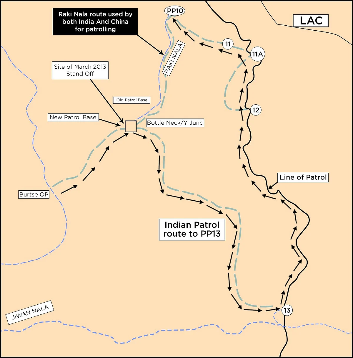
This very useful map with bottleneck, Raki Nalla, other patrol points 10-13:

The Bottleneck point is located around 7 kilometres away from an Indian base at Burtse, which is manned by the Indo-Tibetan Border Police (ITBP) and lies on the newly built 255 kilometre long Darbuk-Shyok-DBO road.
From the Bottleneck, one Indian patrol route leads northwards along the Raki Nala towards PP-10, and then turns east to PP-11 and 11-A and finally towards the south to PP 12. The other Indian route leads south-eastward to PP-13, which lies south of the PPs mentioned above and north of PP-14 in the Galwan Valley, where Indian and Chinese troops had clashed earlier this month.
This is a real and serious concern:
In the 1962 war, Indian Army positions close to Burtse had been captured by the PLA. The Indian Army started returning to this area only in the late 1970s.
In 2008 and 2009, the Chinese troops intrude into this area and destroyed Indian camps near the current day ITBP base in Burtse, “burning fuel stores and rations dumped there for use by Indian patrols”.
With China’s increasing presence here, the PLA may want to shift the LAC westwards. Increasing Chinese transgressions in the larger area — 75 in 2017, 83 in 2018 and 157 in 2019 — also suggest that PLA’s movements, both in the past and now, are aimed at pushing the LAC further west from where it is currently.
While India claims that the Bottleneck point is nearly 18 kilometres on the Indian side of the LAC, China says the line is 5 kilometres west of the point.
If the Chinese positions in the DBO sector and Depsang Plains shift further west, the PLA will be in a better position than before to interdict the Darbuk-Shyok-DBO road in the area during future conflicts with India.
Indian Express article with same information, therefore confirming locations:
https://indianexpress.com/article/india ... s-6474740/
So it turns out that both articles above give a southern location for "Bottleneck" relative to Depsang Plains, and Raki Nalla is also not where pmaitra in the other defense forum put it (it was a heroic effort based on a Himalayan expedition report to Samar lungpa north of DBO). Raki Nalla is a dry river bed running roughly NE to SW towards Burtse, and it defines the southern edge of the Depsang Plains plateau. This changes assumptions on the level of Indian control over the entirety of Depsang Plains. To get to Raki Nalla and PP10, one has to swing south from the Chinese camps shown in Shiv Arror's map. The bottom vertex is Qizl Langar, which is a few kilometers northwest of Burtse:

The strategically located Indian base near the loop in the road shown above is Tac HQ or Track Junction (Swarajya Mag):

Track Junction features regularly in articles about Chinese incursions, now we know why.
Finally, a new article in India Today quoting Raj47 on the Chinese Tianwendian base on the north bank of Chip Chap, to the east of Chinese LAC:
https://www.indiatoday.in/india/story/n ... 2020-06-25
The Tianwendian post -- the oldest post in this area -- was established after the 1962 Sino-Indian war under the garb of an Astronomical Observatory.