no need to fly off the handle. it's a guess by aroor at best and anyway such info is not hidden in today's world from the people who really matter.
going after aroor is the wrong thing, there are dedicated google earth watchers who anyway watch such things.
Google Earth updates more cities and airports in India
Re: Google Earth updates more cities and airports in India
the picture on Livefist says Copyright :ATVP - otherwise ATV Project. Its most likely a hand out given by the ATV project handlers. Shiv Aroor hasnot even pointed that out on GE - merely posted an aerial pic that someone connected to the project has given him.
second - tommorrow when the ATV is launched I would suspect we will see hundreds of pics of the ship builiding complex anyway.
second - tommorrow when the ATV is launched I would suspect we will see hundreds of pics of the ship builiding complex anyway.
Re: Google Earth updates more cities and airports in India
If you had any trouble believing, then the image below will remove all doubts. I quickly made my own comparison images. You can now clearly visualize all the portion that this model is supposed to represent.Akshut wrote:This image is believed to be of a 1.8-square-mile scale model of a disputed region on the border of China and India.

Re: Google Earth updates more cities and airports in India
Hey but this really IS a google earth image in black and white. The damn image is IDENTICAL. From all the tree shadows to the small and big ships visible there to the shadow of the cranes.
How ever I feel that there is no point going after shiv aroor for this. And as Jagan-ji says we have more important things to do - like ordering 6000 to 9000 tons of mithai.
How ever I feel that there is no point going after shiv aroor for this. And as Jagan-ji says we have more important things to do - like ordering 6000 to 9000 tons of mithai.
Re: Google Earth updates more cities and airports in India
Yogi, Akshut,
That image has been on the net for like 4 years now. I think it is only a reflection of how seriously the chinese view the security of this region.
They have calculated, that it will be difficult for them to change an internationally recognized boundary in Arunachal - where India will be defensive only, and they expect India to try and take back Aksai chin - where India is likely to be an aggressor to gain territory. Hence this importance they place on Aksai Chin and Ladakh
Re: Google Earth updates more cities and airports in India
p-Saggu,
Where is Delingha and what can you see around it from Google and Bing and whatever?
VinodTK wrote:Intel centres to keep tabs on China's missiles, navy
Where is Delingha and what can you see around it from Google and Bing and whatever?
Re: Google Earth updates more cities and airports in India
I dont see anything censored there other than the label.rajsunder wrote:I was browsing through taiwan and found that some of the sites have been censored for example
http://wikimapia.org/10932816/Censored-Naval-Area
Is it just a special case for taiwan or is it with every other country?
Re: Google Earth updates more cities and airports in India
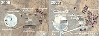
Delinga is a huge flat area in the middle of north tibet where china has a number of missile silos and cememted areas which represent pre-surveyed missile launch sites. The sites are all along a road and about 1 km apart each.
There are two groups of such sites. The eastern group is the one called Delinga Nongchang Facility.
I have the places marked out on my google earth placemark list. please to download. Look in the middle of Tibet for numerous red placemarks along big lakes.
Download link
You can see several such sites on google earth: This article details the area, with some excellent pics and a google earth placemark.
Extensive Nuclear Missile Deployment Area Discovered in Central China
-
Bade
- BRF Oldie
- Posts: 7212
- Joined: 23 May 2002 11:31
- Location: badenberg in US administered part of America
Re: Google Earth updates more cities and airports in India
Why does Google maps show Arunachal Pradesh littered with names in Chinese ? This was not the case many months ago as I recall.
Re: Google Earth updates more cities and airports in India
last time i saw it it was all pixelated. give me some time i will post the imageJagan wrote:I dont see anything censored there other than the label.rajsunder wrote:I was browsing through taiwan and found that some of the sites have been censored for example
http://wikimapia.org/10932816/Censored-Naval-Area
Is it just a special case for taiwan or is it with every other country?
see the Image.
http://picasaweb.google.com/lh/photo/co ... bedwebsite
(to see the above image one needs to sign in to using ur personal gmail)
one can clearly see that the naval base is pixelated compared to the surrounding area.
Re: Google Earth updates more cities and airports in India
You are right, it is pixellated at the max zoom level
http://maps.google.com/maps?t=k&key=ABQ ... 02401&z=19
A quick verification with Google Earth - provides interesting info.
When you zoom in- the imagery is provided by GeoForce Corp - which is a Taiwanese company - and it is they who are censoring the imagery.
There is an option to view "Historical Images" in GE. in that mode, If I select 2008 and view from an altitude of 1000 feet, everything is clear and not pixellated - the image is credited to DigitalGlobe. But IF i zoom in closer than 1000 feet, the image is replaced by the GeoForce Corp IMage and it is pixellated.
Its not Googles fault - but the data providers.

Re: Google Earth updates more cities and airports in India
thanks for the info.Jagan wrote:You are right, it is pixellated at the max zoom level
http://maps.google.com/maps?t=k&key=ABQ ... 02401&z=19
A quick verification with Google Earth - provides interesting info.
When you zoom in- the imagery is provided by GeoForce Corp - which is a Taiwanese company - and it is they who are censoring the imagery.
There is an option to view "Historical Images" in GE. in that mode, If I select 2008 and view from an altitude of 1000 feet, everything is clear and not pixellated - the image is credited to DigitalGlobe. But IF i zoom in closer than 1000 feet, the image is replaced by the GeoForce Corp IMage and it is pixellated.
Its not Googles fault - but the data providers.
Re: Google Earth updates more cities and airports in India
Pakistan's Nuclear Reactors and WMD sites updated. Please add to the earlier download
Pakistan's Nuclear Reactors and WMD
Earlier download
Videshi Maal
Pakistan's Nuclear Reactors and WMD
Earlier download
Videshi Maal
Re: Google Earth updates more cities and airports in India
Breaking news: Please log on to wikimapia.
The chinese characters in Arunachal pradesh are gone. The border is back to yellow color. J&K is now a grey border, with the eastern border missing. If you zoom any closer, the border lines simply disappear.
Looks like GoI cracked the whip, after reading BRF.
The chinese characters in Arunachal pradesh are gone. The border is back to yellow color. J&K is now a grey border, with the eastern border missing. If you zoom any closer, the border lines simply disappear.
Looks like GoI cracked the whip, after reading BRF.
Re: Google Earth updates more cities and airports in India
But google maps is still playing truant.
The red borders are gone, but replaced with a dotted line, the chinese characters are still there.
In J&K google maps is showing the siachen glacier as part of pakistan by showing a dotted line from NJ9842 to the Karakoram pass instead of the AGPL, which is the current placement of the troops in the siachen sector
The AGPL lies as follows. Indira Col - Sia la - Saltoro Kangri 1 - Bilafond La - K12 - Gyong La (Held by India) - NJ9842
As shown in this BRF map.
Re: Google Earth updates more cities and airports in India
X-post.
engti wrote:New member, so apologies if I am posting in the wrong section.
I was recently checking Arunachal Pradesh out on Google Maps, and almost every place had a chinese name.
You can see what I mean by visiting this link http://maps.google.co.in/maps?q=chitrad ... =9&iwloc=A
Screenshot of it here http://twitpic.com/b7hsu/full
While I don't think the Chinese govt. made Google do this directly, what probably what happened is that Google has used some chinese map which showed Arunachal Pradesh as belonging to China.
Still, those of you who know about how disputed this region is, know that there is definitely no way we can allow this to stand, esp. on a site as popular and as heavily used as this.
So anybody has any idea how we can change this? I have tried to raise this with journalists I know. But journos these days have no appreciation of history. Historical claims have been made on our territory on flimsier grounds.
Anyway, if I huffing and puffing for nothing please do tell me so
Re: Google Earth updates more cities and airports in India
Guys, Google has apologized. Says it was due to a technical glitch and will be rectified. Seems Delhi wielded the hammer.
http://timesofindia.indiatimes.com/arti ... 871753.cms
http://timesofindia.indiatimes.com/arti ... 871753.cms
Re: Google Earth updates more cities and airports in India
That red border was there long before the chines characters appeared. The inner red border depicts the china claim line and is mostly aligned along the arunachal-assam border.
google earth is being patently dishonest here. Wikipedia, which uses the same map from google, is more in tune with India's sensitivities. It made that undisputed border what it is, yellow line no red border.
google earth is being patently dishonest here. Wikipedia, which uses the same map from google, is more in tune with India's sensitivities. It made that undisputed border what it is, yellow line no red border.
Re: Google Earth updates more cities and airports in India
Google's apology is an eyewashpmund wrote:Guys, Google has apologized. Says it was due to a technical glitch and will be rectified. Seems Delhi wielded the hammer.
http://timesofindia.indiatimes.com/arti ... 871753.cms
The Google China Maps site shows all of Arunachal, Aksai Chin and parts of Uttarakhand as Chinese territory. Even google maps international shows the area as disputed. Only Google Maps India show these areas as Indian.
Google is trying to please both India and China
http://quickbug.wordpress.com/2009/08/0 ... g-borders/
Re: Google Earth updates more cities and airports in India
so, US foreign policy isn't favoring us even against China? they show sensitive installations and now the borders as disputed
Re: Google Earth updates more cities and airports in India
Arunachal was never disputed territory. Now google earth is converting it into disputed territory in front of our eyes!
The Chinese withdrew from the areas they had advanced into in '62, they did not utter a word on Arunachal all these years, until the chinese ambassador claimed all of it a few years back.
Now google is involved in this and clearly has taken an Anti-India stand.
This was taken just now.

The Chinese withdrew from the areas they had advanced into in '62, they did not utter a word on Arunachal all these years, until the chinese ambassador claimed all of it a few years back.
Now google is involved in this and clearly has taken an Anti-India stand.
This was taken just now.
Re: Google Earth updates more cities and airports in India
Google is still being dishonest: This image was taken from google maps and google earth on 13th August 2009 at 5:45 PM.


Re: Google Earth updates more cities and airports in India
Great, now the whole Uttrakhand border with Tibet is disputed.


Re: Google Earth updates more cities and airports in India
Located the Paki claimed fame to Capture of Kishangarh Fort http://en.wikipedia.org/wiki/Capture_of_Kishangarh_Fort in 65 war. I expected a typical large Rajasthani fort but it turned out to be a mere troop outpost.
Lat 27.871 N
Lon 70.563 E
Edited the wikipedia entry with the link location also but did not know how to embed the link location permanently on the top right corner of the entry page. Help will be appreciated.
Lat 27.871 N
Lon 70.563 E
Edited the wikipedia entry with the link location also but did not know how to embed the link location permanently on the top right corner of the entry page. Help will be appreciated.
Re: Google Earth updates more cities and airports in India
Apparently there are two Kishangarhs in Rajasthan, one about 11 km from the international border and another about 330 km from the international border. All searches on the net and Google earth for the Kishangarh fort captured by the Paki in 65, point to the second Kishangarh. 
-
ashish raval
- BRFite
- Posts: 1390
- Joined: 10 Aug 2006 00:49
- Location: London
- Contact:
Re: Google Earth updates more cities and airports in India
^^ Indian Govt. Should warn Google on the issue and if they dont obliged they should be taken to International court and made to pay hefty price for their error.
Re: Google Earth updates more cities and airports in India
I remember recalling someone posting a pointer to a missile site on google earth showing the concentric circles in the earth.
Since then the image has stuck, and i take all concentric cirlces to be missile sites
Now i saw these circles in TSP and couldn't figure if they were worth anything.
30° 8'19.33"N, 68°37'42.68"E
Kindly forgive this novice if they turn out to be mere mole holes.
Since then the image has stuck, and i take all concentric cirlces to be missile sites
Now i saw these circles in TSP and couldn't figure if they were worth anything.
30° 8'19.33"N, 68°37'42.68"E
Kindly forgive this novice if they turn out to be mere mole holes.
Re: Google Earth updates more cities and airports in India
Mumbai area is updated. Image date : 12 oct'09
Check the airport, shows the work going on , on the secondary runway
Check the airport, shows the work going on , on the secondary runway
Re: Google Earth updates more cities and airports in India
How do you find the date the image was taken?
Re: Google Earth updates more cities and airports in India
Mumbai Chatrapati Shivaji desperately needs a second parallel runway. There is space there if they move that parking lot to where the repair work is going on, and move those slums  .
.
But they will rather build a new greenfield airport than touch those slums. end of story.
But they will rather build a new greenfield airport than touch those slums. end of story.
Re: Google Earth updates more cities and airports in India
When you zoom in, you can see the imagery date:
I dont think parallel runway would be possible at BOM, the reason being, the minimum seperation required between the two runways for simultaneous ops, will be very difficult to fit in.
Secondly, when airports have parallel runway, the terminal is generally between the two, so that you dont have to cut any of the runways .. which wont be the case here.
BOM desperately needs an airport..bigger, better
Re: Google Earth updates more cities and airports in India
SLUMS ==== VOTESGagan wrote:Mumbai Chatrapati Shivaji desperately needs a second parallel runway. There is space there if they move that parking lot to where the repair work is going on, and move those slums
But they will rather build a new greenfield airport than touch those slums. end of story.
NEW AIRPORT ======= KICKBACKS
Re: Google Earth updates more cities and airports in India
Very difficult choice I can see. Maybe this is why the delay is all about in programs all over.
Re: Google Earth updates more cities and airports in India
The Entire Siachen Glacier, Saltoro Range is now in high resolution on Google Earth.
However the image quality has been degraded to not allow any camps to be visible.
In fact the entire north Himalayas are in high resolution now.
This includes K2, Concordia, all the 8000+ meter summits. This is going to be a real boon to mountaineers who'll be able to actually see where they were, perhaps even plan their route.
The security implications for India are obvious, although it is assumed that the pakistanis and the chinese would have access to far more higher resolution images of the area. How ever it is the sheer simplicity of the google earth package with its addons and the cartographic data that enables both ordinary users and military planners to see everything in 3D.
Take a tour today.
Re: Google Earth updates more cities and airports in India
In fact the entire POK, Gilgit Balistan area, is in High res!
Re: Google Earth updates more cities and airports in India
Can some wise gentlemen tell me how to know the coordinates ( latitude, longitude and altitude ) in wikimapia ? In GE it shows very clearly at the bottom of the map.
K
K
Re: Google Earth updates more cities and airports in India
Rezang La.
Rezang La was the place where Major Shaitan Singh and the 123 men of the Charlie-company of the 13 Kumaon fought 1000+ chinese soldiers in 1962. The indians suffered 114 dead and the chinese 500+ dead before the chinese over ran the indian position. The company refused to abandon its positions and exhausted all their ammo before they were all killed. Major Shaitan Singh was awarded the PVC posthumously. The memorial to this epic battle reads:
The trenches, bunkers and gun positions are visible. Today this place is in Chinese hands.

Rezang La was the place where Major Shaitan Singh and the 123 men of the Charlie-company of the 13 Kumaon fought 1000+ chinese soldiers in 1962. The indians suffered 114 dead and the chinese 500+ dead before the chinese over ran the indian position. The company refused to abandon its positions and exhausted all their ammo before they were all killed. Major Shaitan Singh was awarded the PVC posthumously. The memorial to this epic battle reads:
How can a Man die Better than facing Fearful Odds,
For the Ashes of His Fathers and the Temples of His Gods,
To the sacred memory of the Heroes of Rezang La,
114 Martyrs of 13 Kumaon who fought to the Last Man,
Last Round, Against Hordes of Chinese on 18 November 1962.
"When Rezang La was later revisited dead jawans were found in the trenches still holding on to their weapons... every single man of this company was found dead in his trench with several bullet or splinter wounds. The 2-inch mortar man died with a bomb still in his hand. The medical orderly had a syringe and bandage in his hands when the Chinese bullet hit him... Of the thousand mortar bombs with the defenders all but seven had been fired and the rest were ready to be fired when the (mortar) section was overrun."
The trenches, bunkers and gun positions are visible. Today this place is in Chinese hands.
Last edited by Gagan on 18 Jan 2010 23:12, edited 1 time in total.
Re: Google Earth updates more cities and airports in India
I don't think that they offer this on wikimapia. I usually alternate betweenKersi D wrote:Can some wise gentlemen tell me how to know the coordinates ( latitude, longitude and altitude ) in wikimapia ? In GE it shows very clearly at the bottom of the map.
K
1. Wikimapia Satellite
2. Satellite + Old places and
3. Google Hybrid
map types on Wikimapia. All have different markings and will help identify roads, placemarks put there by people.
Re: Google Earth updates more cities and airports in India
Google maps shows a couple of C130s parked at Agra. Anyone know whose they are? I dont think we have ours yet.