Amber G. wrote: ↑22 Mar 2026 10:06
“Nonsense” is dismissing the basics. A degraded NavIC isn’t “useless”—loss of navigation ≠ loss of function; satellites can still provide timing and messaging, which are operationally relevant. And no, the Agni series isn’t a plug-and-play satellite launcher. Push back is fine—but it should be grounded in how the system actually works, not in caricatures.
These kinds of posts are why you appear to miss the point, either unintentionally or deliberately
NavIC is dead, or at least crippled. Its useless for missile navigation. Its shameful that we let it come to this
This is the simple truth. No amount of 1000 word explanations are going to change this basic fact
Prem Kumar ji,
single point of failure, the design disaster that one is always taught to guard against
Re: Indian Space Program: News & Discussion
Posted: 22 Mar 2026 19:12
by Tanaji
Chetakji,
Most likely what happened was this: ISRO came up with a resilient design that would cater for 2-3 failures of satellites without loss of performance. The DoS babooze would have pushed back saying “no need for resiliency, unnecessary expense , remove the extra sats” given their superior intelligence in all matters due to their success at UPS exam. ISRO designer would have then pushed back asking for funds for reserve sats., which would have been canned by babooze as well.
Here is where bad PM kicks in and a good PM would have made this non negotiable…. We had worse luck as all the clocks failed…
Yes, FOB, ASAT ... As said before this is about small, rapid LEO launches—not NavIC-class satellites; completely different mission and precision requirements.
(Hint typical NaviC sat are about 36,000 Km high -- When fully ready in future - can launch small LEO satellites quickly but cannot replace navigation satellites (NavIC class) which are heavy, require precise GEO/IGSO insertion, and need high-accuracy orbital placement)
Re: Indian Space Program: News & Discussion
Posted: 22 Mar 2026 23:43
by Tanaji
Is there an estimate on how many satellites in LEO orbit would be required to have at least 5 satellites overhead the Indian landmass at any given time?
It would be interesting to see how the economics stacks up this way as opposed to geosats.
This week SpaceX passed an eye-watering milestone: it launched its 10,000th satellite into low-Earth orbit
Re: Indian Space Program: News & Discussion
Posted: 23 Mar 2026 22:26
by Amber G.
Tanaji wrote: ↑22 Mar 2026 23:43
Is there an estimate on how many satellites in LEO orbit would be required to have at least 5 satellites overhead the Indian landmass at any given time?
It would be interesting to see how the economics stacks up this way as opposed to geosats.
FWIW My take (Assuming the question is serious:- please read on)
Good question—but it’s not a simple apples-to-apples swap.
You can absolutely build a LEO-based regional system—but it trades:
Fewer, expensive, long-lived GEO sats
for
many, cheaper, short-lived LEO sats + higher operational complexity
That’s why most GNSS (and NavIC) chose the high-orbit route—not because LEO is impossible, but because the total system economics and stability tend to favor fewer satellites at higher altitude.
Basics:
For continuous coverage over India with ≥5 satellites visible at all times, a rough order-of-magnitude is :
~ 50 LEO satellites (depending on altitude, inclination, and elevation mask)
Why so many? LEO sats (~500–1000 km) move fast → each is visible only 5–10 minutes per pass
You need multiple orbital planes + phasing to maintain continuous overlap And you need margin for GDOP, not just visibility.. (If you want, I can sketch a quick back-of-the-envelope constellation (planes, inclination, revisit time) to show where this about 50 number comes from )
GEO is ~40× higher orbit and much stricter insertion precision.
Economics vs GEO (like NavIC)
LEO approach:
Lower per-satellite cost, Easier launches (smaller rockets), Many more satellites (~50 vs ~7), Continuous replenishment every ~5 years -- MUCH larger ground/control complexity
GEO/IGSO (NavIC):
Very few satellites (~7), Continuous coverage over India, Long lifetimes (~10–12 years), Higher per-satellite cost, Demanding launch precision
Re: Indian Space Program: News & Discussion
Posted: 23 Mar 2026 23:41
by Tanaji
Why wouldnt it be a serious question?
Access to space is getting easier and cost per kg is falling year on year. However, this is for lower orbits where there are lots of players. At LEO we can benefit from a smaller size satellite hopefully as power requirements are lesser for transmitted power due to closer distance, which means a smaller solar panel, antenna etc. This would translate to smaller payload. I have no idea what weight would be but perhaps PSLV could launch 2 at a time?
Although the 50 number was more than I expected, I sort of thought it to be closer to 30 for no reason. The economics wont work out in that case I would guess. If we have 3 geosats working, perhaps some sort of coverage could be worked out with lesser number of LEO satellites
India’s NavIC (Navigation with Indian Constellation) is a regional satellite navigation system developed to provide accurate positioning, navigation, and timing (PNT) services across India and up to 1,500 kilometers beyond its borders, with plans for a further extension out to 3,000 kilometers. Originally known as the Indian Regional Navigation Satellite System (IRNSS), it has been designed, developed, and operated by the Indian Space Research Organisation (ISRO).
Unlike global satellite navigation systems such as GPS, which deploy satellites in medium Earth orbit (MEO), NavIC is a regional system that uses seven satellites (along with backups) placed in geostationary and geosynchronous orbits. NavIC provides two main services: the Standard Positioning Service (SPS), offering accuracy of about 5–20 meters for civilian use, and the Restricted Service (RS), intended for strategic users. The first satellite in this constellation was launched in 2013, and the system was declared operational by 2018.
Today, NavIC, is facing a major service disruption, with only three satellites currently being functional. A minimum of four functional satellites are required for accurate positioning. Recently, ISRO declared that the atomic clock of the ten-year-old IRNSS-1F satellite has failed on March 13.
This follows earlier setbacks like the flawed launch of the next-generation NVS-02 satellite in January 2025. In a February 25 statement, ISRO announced the outcome of an investigation about this failure. NVS-02 was successfully placed into a geostationary transfer orbit, but failed to reach its intended final orbit because its onboard engine could not fire. The investigation found that a pyrotechnic valve in the engine had failed to open due to a command signal not reaching it, and thus blocking oxidizer flow to the orbit-raising engine.
For a variety of reasons, six of the 11 satellites launched by ISRO for the purposes of navigation have suffered failures or partial failures. Many failures were mainly associated with the problems in Swiss-made atomic clocks. Apart from this, IRNSS/NavIC satellite failures have stemmed from reasons such as engine and valve failures, missed command signals, and aging hardware. Reliance on imported components and insufficient redundancy have further degraded constellation reliability.
The term “jinxed” is scientifically incorrect because it suggests that failures are caused by bad luck rather than identifiable technical issues. In reality, the IRNSS/NavIC satellite failures have clear known causes. Yet, given ISRO’s otherwise impressive track record of successes in other major space projects, the repeated setbacks in the NavIC program are almost making people to think that ISRO’s navigational program is jinxed!
Experiencing failures and encountering malfunctions are not uncommon for space agencies worldwide. However, for ISRO, NavIC poses a challenge, since it is not about any single failure but instead a compounding series of technical setbacks.
All this has made the India’s navigation system dysfunctional, which has both civilian and strategic importance. Amid ongoing military operations in India’s backyard, happening in the Iranian and Afghanistan theatres, the importance of a fully functional satellite navigation system for India has never been clearer. Experiences from India’s own Operation Sindhoor (May 6–7, 2025) had highlighted NavIC’s limitations and the risk of operating with a partially dysfunctional constellation. For, India the challenge is more acute since China provides military-grade BeiDou signals to Pakistan. In the Asia-Pacific region, experts feel that BeiDou’s performance is better than GPS.
Various recent conflicts like Armenia‑Azerbaijan, Russia‑Ukraine, and US/Israel-Iran have shown how unmanned aerial vehicles or drones can decisively shape battles of the day. Beyond-visual-range engagements, precision-guided munitions, joint direct attack munitions, hypersonic weapons, and missile defense systems are now central to modern military conflicts. These military systems rely heavily on accurate, real-time positioning and targeting data. Major militaries all over the world are depending mainly on timely satellite-derived information to detect, track, and intercept threats. Hence, a reliable space-based navigation system is a critical enabler for operational effectiveness and central to battlefield success.
Like other major space programs around the world, ISRO has suffered its share of failures, and there is no assurance that future missions will be free from setbacks. However, the challenges facing NavIC appear to extend beyond purely technological glitches or supply chain constraints. These failures are pointing towards deeper policy and planning issues such as delays in satellite replacement, gaps in constellation planning, delays in indigenous development of atomic clocks, limited redundancy, and slower integration with civilian and strategic users. Essentially, there is a requirement of putting development of this program in a mode with a stronger policy framework, better long-term planning, and clearer prioritization among the other big programs being developed by ISRO.
Along with the satellite operations, there have also been problems with the user segment. According to ISRO, the user segment mainly consists of a single-frequency IRNSS receiver capable of receiving the signal at L5 or S-band frequency, a dual-frequency IRNSS receiver capable of receiving both L5 and S-band frequencies, and a receiver compatible to IRNSS and other GNSS signals. It is difficult to realize how a professional organisation like ISRO had sidelined the issues related to the development of ground elements and the user segment during the initial phase of the program. For some years, some of their navigation satellites were idle in space since there was no ground network planed for making the signal available for the common users and this has turned precious investments meaningless.
In fact, the Comptroller and Auditor General of India (CAG) had flagged delays and cost overruns in the NavIC project, noting that the system was not fully operational as of June 2017. According to the report, by March 2017 ISRO had incurred a total expenditure of approximately $375–380 million, including both core program and launch vehicles, satellite maintenance, and ground infrastructure. The system was expected to become widely available in a user-friendly mode by April 2020; however, while NavIC services have since been operational, adoption has remained much limited. Even by 2026, its use on mainstream mobile devices, though enabled in some chipsets, is still not yet prevalent, and common mobile users in India do not have easy access to NavIC.
What do the setbacks in NavIC indicate? Rather than pointing to a single cause, they raise broader policy queries about prioritization and sequencing in regards to the nature of projects undertaken by ISRO. Has the success of high-visibility missions like missions to Moon and Mars encouraged a push toward more ambitious, stature-driven projects like human spaceflight and plans for a space station and mission to Venus, without first fully consolidating critical strategic systems like satellite navigation? Is ISRO “punching above its weight” within limited resources while attention is being spread too thin, creating gaps in core capabilities that have direct strategic and civilian implications? By contrast, major space powers like the United States, China, and Russia have historically ensured that foundational critical space infrastructure like robust navigation, communication, and surveillance systems, is firmly in place before expanding into more symbolic or exploratory missions. The NavIC story should be an eye opener to India’s policy planners, demonstrating the requirement for India to have a sharper policy focus on strengthening strategic necessities first.
Re: Indian Space Program: News & Discussion
Posted: 24 Mar 2026 23:31
by Amber G.
Meanwhile: Some exciting happening , which is also making news in Indian Media:
Researchers from IIT Kharagpur and the PRL have explained how the Moon’s titanium-rich rocks (ilmenite-bearing cumulates) formed deep inside the lunar interior billions of years ago, as a global magma ocean cooled and dense layers sank. Their lab simulations show that these rocks can partially melt under extreme conditions to produce different types of titanium-rich magmas, which helps explain the high-Ti basalts observed on the Moon’s surface.
The study also suggests the Moon’s interior was dynamically evolving, with material both rising and sinking (mantle overturn), rather than being static. These insights are important for Chandrayaan-4, as they can help identify promising landing sites and better interpret the samples the mission aims to bring back.
{My comments}: Moon turns out to be far less “geologically dead” (at least in its past) than people used to think.
That whole idea of a global magma ocean → layering → overturn → resurfacing is almost like a slow-motion convection experiment on a planetary scale. And titanium-rich basalts are especially interesting because they hint at chemically distinct reservoirs deep inside—almost like the Moon had its own version of mantle differentiation, just simpler than Earth’s.
For Chandrayaan-4, this is gold - if you know where high-Ti materials likely originated, you can target sites that tell you not just what’s on the surface, but what was happening deep inside the Moon billions of years ago.It's like doing geophysics without drilling—just by picking the right rocks to bring back.
The Dept of Space, the PMO & ISRO all need a collective kick in the butt. They need to cancel all "pride" programs like Shukrayaan, Gaganyaan etc and focus entirely on military requirements for the next decade. That's how far behind we are
Also, just because the root-causes are varied doesn't mean we rule out sabotage. As Stuxnet and other incidents have demonstrated, a sophisticated adversary will cleverly make failures look disconnected & natural. Part of our military preparedness is to harden our defenses and create counter-offensive capabilities as well
Re: Indian Space Program: News & Discussion
Posted: 25 Mar 2026 19:57
by Sachin
Prem Kumar wrote: ↑25 Mar 2026 12:46
The Dept of Space, the PMO & ISRO all need a collective kick in the butt. They need to cancel all "pride" programs like Shukrayaan, Gaganyaan etc and focus entirely on military requirements for the next decade.
Am I the only one to believe that if these trends continue NaMo's and BJP's focus on show casing each and every thing to score political glory would soon backfire before the next round of Lok Sabha elections? Many hyped programs seems to be executed with real poor quality with a hope that government can cover that up with more jingoism.
Re: Indian Space Program: News & Discussion
Posted: 26 Mar 2026 02:50
by Tanaji
Sachinji,
I am in full agreement with you. I fear the next LokSabha election is going to be a India Shining moment for BJP unless it quickly course corrects. Modiji and hence the BJP is giving out the impression of being a bit haughty and this is never a good look. BJP needs to realise the next election will have a lot of voters that are too young to know what life under Congress was like, so will be swayed easily. UGC, poorly run schemes are not helping it.
Anyway its OT for this thread, we should start a new thread on this..
Re: Indian Space Program: News & Discussion
Posted: 26 Mar 2026 07:46
by Amber G.
MY TAKE: On the "NavIC is Dead" Rhetoric (IMO, honest/blunt)
Claiming NavIC is "DEAD" because of a replenishment delay is like channeling Rahul Gandhi (Really!) 'the Indian economy is dead" narrative—it’s loud rhetoric fueled by an ignorance of basic facts. A system under maintenance is not a system in a coffin.
What is actually "shameful" is dismissing clear, scientific explanations in favor of insinuating sabotage or hiding behind "eggplant emojis" and "lungi dance" memes. Resorting to such tropes doesn't make a technical argument; it just signals a lack of one.
If a Nav cluster is in a gap, you fix the hardware and the policy. You don't declare a strategic pillar "useless" because you can't distinguish between a temporary outage and a total failure.
"Confusing a gap in the replenishment cycle with a systemic death isn't 'tough talk'— (Again channeling LoP "NaMo's BJP/scientists are compromised ") 'sit’s just bad engineering logic wrapped in silly rhetoric."
For those who want a serious discussion, it can be carried over <here [Link] > > as NavIC, as Tanaji said deserves its own thread.
{@sridhar et all - NaviC and Indian Navigation deserves its own thread - we can move a few last messages there to keep in clean - I will start a new thread to summarize these posts, including current newspaper articles and show what some of us think}
Nice try Amber G, trying to burn a strawman. No one here says NavIC cannot (or should not) be revived. In fact almost unanimously, everyone is clamoring precisely for it - and asking that military space programs be prioritized, instead of vanity projects
But NavIC is currently dead/crippled. And its shameful that the PMO, Dept of Space & ISRO, due to their lack of funding/care/planning etc let it happen
Your repeated assertions that "all is well" makes one wonder about your motivations. People who mean well, critique constructively - not lull someone into a false sense of security. Your repeated posts of this nature in military space programs, nuclear-weapons program etc makes me wonder if you want India to be a vassal-state like Japan. You repeatedly assert that India be happy with civilian progress, but never military ones
Most here want India to progress on both fronts and become a superpower all around. I am not sure if you share that same worldview
NVS-03 and 04 is planned to be launched in 2026. The failure of NVS-02 to the reach the intended orbit was studied, identified and fixed. So with these two launches, in 2026, the system will start gaining numbers.
Re: Indian Space Program: News & Discussion
Posted: 26 Mar 2026 11:39
by drnayar
uddu wrote: ↑26 Mar 2026 10:22
NVS-03 and 04 is planned to be launched in 2026. The failure of NVS-02 to the reach the intended orbit was studied, identified and fixed. So with these two launches, in 2026, the system will start gaining numbers.
The first of the three, NVS-03, is scheduled to be launched by year-end. The other two, NVS-04 and NVS-05, will be launched after that “with a gap of six months,” as per data.
Re: Indian Space Program: News & Discussion
Posted: 26 Mar 2026 12:38
by Kanoji
Prem Kumar wrote: ↑26 Mar 2026 09:59
But NavIC is currently dead/crippled. And its shameful that the PMO, Dept of Space & ISRO, due to their lack of funding/care/planning etc let it happen
Prem Kumar Ji,
It is concerning to know that the Department of Space which comes directly under the PMO has put the country in such a situation. Being under the PMO, I assume, ISRO will not have budgetry constraints. I am not sure if it is a lack of technology or strategic planning which has brought us to this situation.
Does ISRO not have a technology forecasting cell that identifies critical technologies to be mastered indigenously? What about TIFAC set up by Dr APJ?
It is time to set up a dedicated military space wing to look after and prioritize the exclusive space requirements of the armed forces.
India’s space agency, Indian Space Research Organisation, is preparing to undertake two advanced orbital docking experiments as part of its long-term roadmap to build and operate the Bharatiya Antariksha Station.
The upcoming missions, SPADEX-2 and SPADEX-3, will expand on earlier docking demonstrations and test capabilities critical for future human spaceflight and lunar missions.
According to information shared in Parliament by Jitendra Singh, the two missions are currently under study and will simulate docking under different orbital conditions.
SPADEX-2 will focus on docking and undocking two spacecraft in a highly elliptical orbit, a complex environment required for future missions such as Chandrayaan-4.
The mission will also attempt sample transfer between two modules, a key capability for returning material from the Moon.
SPADEX-3, on the other hand, will demonstrate docking in a circular orbit, similar to low Earth orbit conditions. This mission is designed as a precursor to docking operations for the Bharatiya Antariksha Station.
It will involve docking between two pressurised modules using the indigenous Bharatiya Docking System (BDS), a technology crucial for crewed missions and long-duration stays in orbit.
uddu wrote: ↑26 Mar 2026 10:22
NVS-03 and 04 is planned to be launched in 2026. The failure of NVS-02 to the reach the intended orbit was studied, identified and fixed. So with these two launches, in 2026, the system will start gaining numbers.
The first of the three, NVS-03, is scheduled to be launched by year-end. The other two, NVS-04 and NVS-05, will be launched after that “with a gap of six months,” as per data.
Yes Sir. The article is from 2025. The launch did not happen and is pushed to First quarter of 2026. NVS-03 is expected to be launched in April 2026.
Prem Kumar wrote: ↑26 Mar 2026 09:59
Nice try Amber G, trying to burn a strawman. ...
But NavIC is currently dead/crippled. And its shameful that the PMO, Dept of Space & ISRO, due to their lack of funding/care/planning etc let it happen ..
...
Your repeated assertions that "all is well" makes one wonder about your motivations.... Your repeated posts of this nature in military space programs, nuclear-weapons program etc makes me wonder if you want India to be a vassal-state like Japan. You repeatedly assert that India be happy with civilian progress, but never military ones..
Most here want India to progress on both fronts and become a superpower all around. I am not sure if you share that same worldview
Let’s drop the personal speculation—that’s not a substitute for technical argument.
Also, this repeated “NavIC is dead” line (to borrow from Rahul Gandhi’s shameful stunts) is getting a bit tired. It’s catchy, but it’s not accurate.
NavIC is degraded, not dead. There’s a difference between:
loss of some navigation capability, and loss of the system itself
Satellites like IRNSS-1F losing atomic clocks affect precision ranging, not the entire spacecraft. Timing, messaging, and partial geometry remain. In a 7-satellite system, even 1–2 failures look dramatic—that’s arithmetic, not collapse.
On “shameful mismanagement”:
Yes—replacement cadence should have been tighter. That’s a fair criticism. But jumping from that to “dead system / PMO failure / sabotage / vassal state” is not analysis—it’s stunt like RG channeling 'you are compromised '
On defence impact:
Modern systems don’t rely on a single constellation. It’s INS + multi-GNSS + timing discipline. Even a partially degraded NavIC still provides regional timing, which is often the more critical function in practice. (If genuinely interested, see my post in other dhaga - in details)
As for the The Hindu article—you can find similar framing across multiple outlets: ( Also see this article being discussed here : viewtopic.php?p=2676026#p2676026
----
“security capability reduced” → overstated
“system not functioning” → incorrect
no distinction between clock failure vs satellite failure
Same pattern: correct facts, exaggerated conclusions.
If the goal is improvement, then the real discussion is:
Everything else—labels like “dead” or questioning motivations—just adds noise without improving the system.
- Amber G.
(Please continue discussion in the other dhaga)
Re: Indian Space Program: News & Discussion
Posted: 27 Mar 2026 07:33
by Amber G.
Sharing Isro building Bharatiya Antariksh Station The overall configuration of the Bharatiya Antariksh Station (BAS) has already been reviewed by a national-level committee, marking a key milestone in the country's human spaceflight ambitions.
Re: Indian Space Program: News & Discussion
Posted: 28 Mar 2026 03:37
by Amber G.
Sachin, Prem, Tanji, and others: These type of questions are valid. Some comments:
The Dept of Space, the PMO & ISRO all need a collective kick in the butt. They need to cancel all "pride" programs like Shukrayaan, Gaganyaan etc and focus entirely on military requirements for the next decade.
Am I the only one to believe that if these trends continue NaMo's and BJP's focus on show casing each and every thing to score political glory would soon backfire before the next round of Lok Sabha elections? Many hyped programs seems to be executed with real poor quality with a hope that government can cover that up with more jingoism.
It’s refreshing to see someone engaging with national policy with this level of skepticism—honestly, questioning the "why" behind massive public spending is a hallmark of a healthy democracy. You’re definitely not the only one feeling that "showcase fatigue," and your point about the pressure of political optics potentially compromising quality is a valid concern.
These kind of questions—including the tough ones—are actually good for democratic systems. At the same time, we should also strive to separate the noise from the facts. This is how the strategic reality of these programs often looks when you peel back the PR:
NavIC & Strategic Independence: The NavIC system isn't just a "desh-ka-GPS" branding exercise. It provides a restricted, encrypted service specifically for the Indian Armed Forces, ensuring secure navigation and timing support independent of foreign systems (a lesson learned from the 1999 Kargil War). Interestingly, the precise timing required for this synchronization is supported by advanced research at the Physical Research Laboratory (PRL), which is crucial for maintaining the nanosecond accuracy the military needs for tactical coordination.
Cutting-Edge Encryption: Security isn't just about hardware; it's about the math. There is currently a highly sophisticated, indigenous encryption system in use that was developed by a renowned mathematician from IIT Kanpur. This kind of collaboration between elite academia and national defense is what "pride" programs like ISRO’s help facilitate and fund.
Dual-Use Technology: There isn't a hard wall between "pride" and "military" requirements. The cryogenic engines for Gaganyaan and the heavy-lift rockets for Shukrayaan provide the exact propulsion tech needed for long-range defense and heavy-payload logistics.
The Risk of Jingoism: You’ve hit on a critical point regarding quality. If political glory leads to cutting corners, it becomes a massive liability. In the space sector, failure is binary—you can't "spin" a crashed lander. If "showcasing" compromises engineering, it would backfire before any election could save it.
Brain Drain: Programs like ISRO's deep-space missions are what keep India's top engineering talent from migrating to SpaceX or NASA. To have a strong military, you need to keep that intellectual capital at home.
Quick Comparison:
Focus/ The Political "Noise"/ The Strategic "Fact"
Gaganyaan / A high-profile PR event. / Mastering life support and reentry for future space-based defense.
NavIC / An indigenous GPS alternative. /Secure, unhackable PNT (Positioning, Navigation, Timing) for the military.
IITK Encryption / Academic research project./ Real-world, unhackable defense communications infrastructure.
It is entirely fair to demand that substance outpace the "hype," but often, the very programs labeled as "pride" are the R&D labs for the military's future hardware.
Let me leave a you tube video for members here: NavIC: India's indigenous navigation system
(This video explains the strategic importance of NavIC and the quantum-secure communication networks being developed in India.)
Re: Indian Space Program: News & Discussion
Posted: 28 Mar 2026 09:52
by uddu
The Orbital Frontier: Deterrence and Resilience in Contested Space Space security is shifting from a strategic concern to a defining test of deterrence, resilience, and crisis management in orbit. This session examines how states can assert their autonomous capabilities, accommodate collaboration, and advance responsible behaviour in an increasingly congested and contested space domain.
Given that some adversaries are investing in counter-space weapons, what investments in resilient architectures and which forms of allied burden-sharing are you looking at to maintain the upper hand in any potential confrontation in orbit?
How can collaboration be structured so partners gain interoperability and shared awareness without creating single points of failure, dependency risks, or technology-leakage concerns?
How can responsible behaviour be codified for space?
Can they be operationalised in such a way that deterrence remains credible, and the domain stable?
Speaker:
General Stephen N. Whiting, Commander, U.S. Space Command, United States of America
Moderator: Palki Sharma, Managing Editor, Firstpost, India
The Artemis program is a Moon exploration program led by the United States' National Aeronautics and Space Administration (NASA), formally established in 2017 through Space Policy Directive 1. By 2028, the program aims to return humans to the lunar surface for the first time since Apollo 17 in 1972. It also intends to establish a permanent base on the Moon in the 2030s, as a stepping stone to human missions to Mars.
Artemis II is NASA's first crewed mission back to the Moon in over 50 years, planned for 2026.
It is not a landing mission, but a, flyby of the Moon to test systems for future landings
India has signed the Artemis Accords to collaborate with NASA on peaceful, sustainable lunar exploration, becoming the 27th signatory in June 2023. India is not a direct participant in the core Artemis crewed missions, India aims for a human lunar landing by 2040, aligning with the long-term goals of the global space community.
Re: Indian Space Program: News & Discussion
Posted: 03 Apr 2026 16:13
by SRajesh
Question to Dr Nayarji and Premkumarji and Forum members :
Should we invest only in the Quantum Satellite technology or
Should it be in parallel development to NAVIC.
Have both the systems.
Do Mobile compaines and civilian users need to pay for GPS use??
If so a secure and reliable NAVIC will be a commercial alternative to GPS and even undercut and surpass GPS??
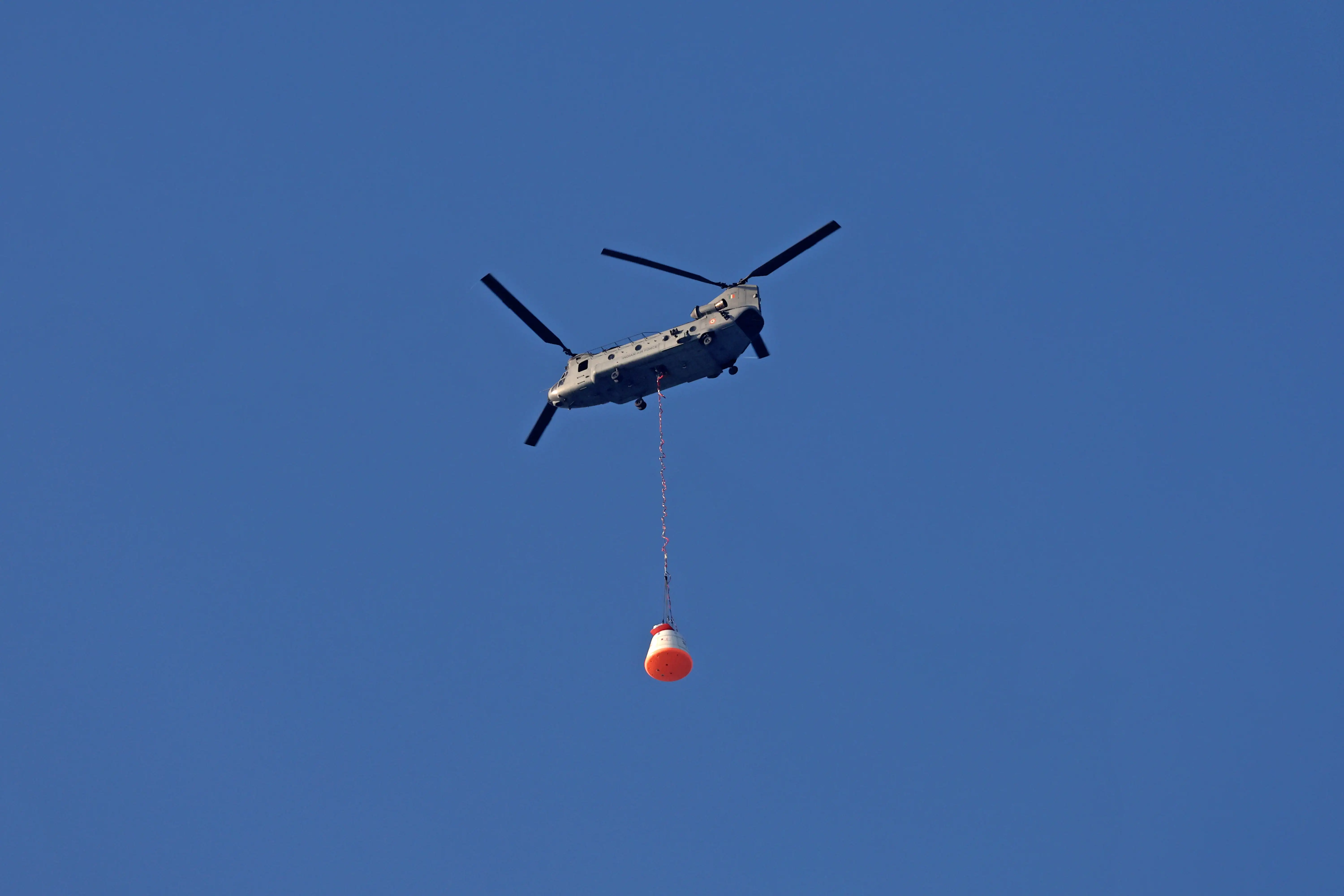
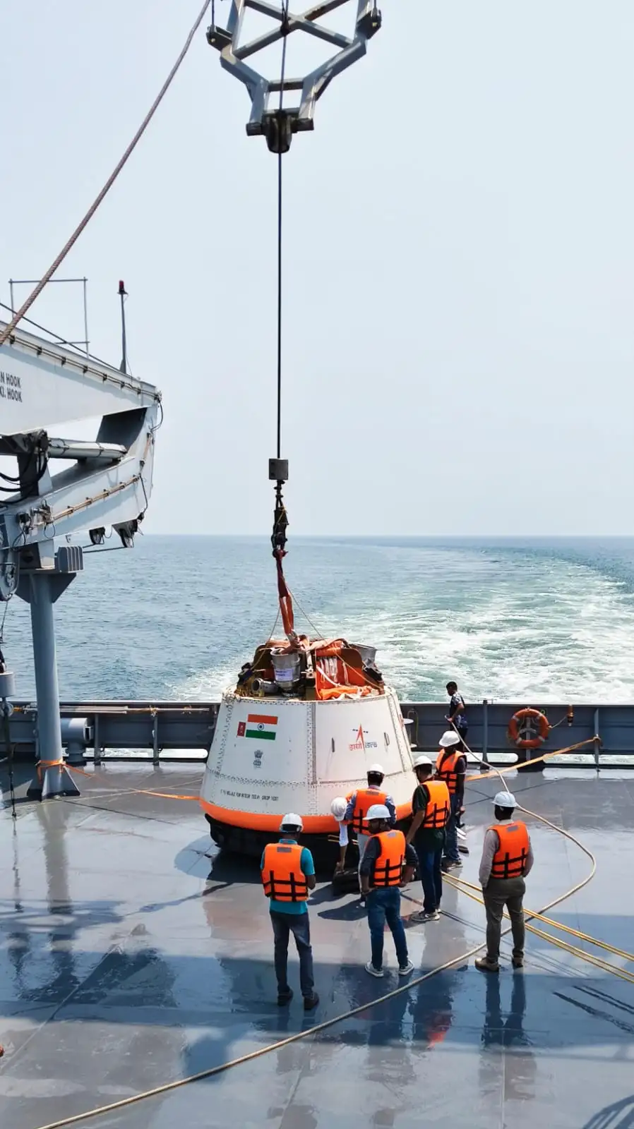
The second Integrated Air Drop Test (IADT-02) for Gaganyaan mission was successfully conducted at Satish Dhawan Space Centre, Sriharikota on April 10, 2026. In this test, a simulated Crew Module, weighing about 5.7 tonnes, that is equivalent to the mass of the Crew Module in the first uncrewed Gaganyaan mission (G1), was lifted by an Indian Air Force Chinook helicopter to an altitude of about 3km and released over a designated drop zone in sea, near to Sriharikota coast.
Ten parachutes of four types were deployed in a precise sequence during the descent of the Crew Module, gradually reducing the velocity for safe touchdown. Subsequently, the simulated Crew Module was successfully recovered in coordination with Indian Navy. The IADT-02 test validated the parachute-based deceleration systems in the Crew Module.
This test marks another significant step towards the readiness for the Gaganyaan G1 Mission, with active support and participation from the Indian Air Force, Indian Navy, and Defence Research & Development Organisation (DRDO).
Paging AmberG for comments on the new clocks for NavIC. Thank you in advance.
Re: Indian Space Program: News & Discussion
Posted: 13 Apr 2026 06:32
by drnayar
SRajesh wrote: ↑03 Apr 2026 16:13
Question to Dr Nayarji and Premkumarji and Forum members :
Should we invest only in the Quantum Satellite technology or
Should it be in parallel development to NAVIC.
Have both the systems.
Do Mobile compaines and civilian users need to pay for GPS use??
If so a secure and reliable NAVIC will be a commercial alternative to GPS and even undercut and surpass GPS??
Investing in both systems in parallel is the current global strategic consensus. Quantum navigation and satellite-based systems like NavIC serve different but complementary roles in a modern "sensor fusion" approach.
Quantum Satellite/Navigation: Primarily acts as a tamper-proof backup. It uses ultra-precise quantum sensors (atomic clocks and accelerometers) that do not rely on external signals, making them immune to the jamming or "spoofing" that can plague GPS.but significant weight penalty (currently)
NavIC : Provides immediate, wide-scale availability for daily tasks like smartphone navigation and vehicle tracking. It is essential for regional sovereignty and strategic independence.
NavIC uses dual-frequency bands (L5 and S-band), which can provide better accuracy in tropical regions like India compared to standard single-band GPS.Unlike GPS, which is controlled by the U.S. military and could theoretically be degraded or denied in specific regions during conflicts, NavIC is under local control, ensuring guaranteed service for regional users.
Re: Indian Space Program: News & Discussion
Posted: 13 Apr 2026 06:55
by bala
On Gaganyaan : has ISRO demonstrated heat shield for the capsule?
Re: Indian Space Program: News & Discussion
Posted: 13 Apr 2026 10:40
by SSridhar
SRajesh wrote: ↑03 Apr 2026 16:13
Question to Dr Nayarji and Premkumarji and Forum members :
Should we invest only in the Quantum Satellite technology or
Should it be in parallel development to NAVIC.
Have both the systems.
Do Mobile compaines and civilian users need to pay for GPS use??
If so a secure and reliable NAVIC will be a commercial alternative to GPS and even undercut and surpass GPS??
Safe and secure key distribution is the most fundamental problem in cryptography. Quantum Satellites are today being developed essentially for secure quantum key distribution. Quantum Key Distribution (QKD) is the QC equivalent of key distribution using asymmetric keys in PKI in classical computing. QKD is tamper-evident also in the sense that if an eavesdropper is able to decipher the quantum key while being distributed, it will be known to the recipient because of the quantum nature where any measurement collapses the quantum state, and key distribution can therefore be aborted. This is not possible in classical cryptography of today. What QKD does is to remove the dependency for secrecy on the availability of computing power and take it instead to fundamental physical laws.
QC Satellites do not obviate the need for atomic clocks and NavIC.
GalaxEye is launching a satellite that has both optical and SAR payloads. The concept itself is not new - other providers have sats that work in pairs such as Sentinel 1 with SAR and Sentinel 2 with optical sensors. The value is in the fusion of their outputs to provide a combined picture. I think this is probably what GalaxEye is doing - their secret sauce is in the algorithms for the fusion and for that they want a platform they can control from ground up. Its creditable that they are taking the risk for the same - other startups would have just bought commercial imagery and run algorithms on it. This is true development I think and moving the Indian eco system forward. They have started with 1.5 m resolution and plan a constellation with progressively more resolution.
Its a pity they cant use an Indian launcher and I dont blame them. ISRO is stuck in its 80s and 90s ways where 1-2 launches a year is a matter of celebration. Things have moved on and ISRO hasn't. Its launch frequency and lack of reuse is appalling to say the least.
Re: Indian Space Program: News & Discussion
Posted: 03 May 2026 17:34
by Ashokk
India is preparing to launch a satellite unlike any the world has seen before. Built by a young private space startup and designed to see through clouds and darkness, the mission marks a turning point for India’s space ecosystem. At the heart of this effort is Drishti, a uniquely engineered Earth observation satellite developed by Bengaluru-based GalaxEye and set to fly aboard SpaceX’s Falcon 9 rocket. The launch will take place from California on Sunday, May 3, 2026, at 12:29 PM IST.
Re: Indian Space Program: News & Discussion
Posted: 05 May 2026 20:51
by Amber G.
Pixxel will design, build, launch, and operate the satellite, and Sarvam will provide the AI backbone
NOTAM for GSLV-F17 / EOS-05 (aka GISAT-1A) launch is out. Enforcement duration 0315-0715 (UTC), 21 May to 10 June 2026.
Re: Indian Space Program: News & Discussion
Posted: 13 May 2026 04:01
by Amber G.
The Smithsonian added Nandini Harinath's saree to its space exploration exhibit in Washington.
Harinath wore the saree during India's Mars Orbiter Mission launch in 2013.
She was deputy operations director and key to the mission's success at ISRO
Re: Indian Space Program: News & Discussion
Posted: 15 May 2026 11:47
by S_Madhukar
Don’t know what to make of that saree. Acknowledgment that some so called tribal communities were able to launch to space? If it was a uniform I might have been able to understand or there are other female scientists whose apparel has been displayed