This Abdul had surmised some time back that any deviation in the flight path of Malaysian Airline flight would pop-up on military radar which would be scanning the area. And the latest news item linked shows that the aircraft was indeed tracked by Royal Malaysian Air Force (RMAF) radar out of Butterworth.
As usual, I made use of Google Maps and Wikimapia

to try and make sense of the situation as there are some points which don’t add up. Refer to the maps as I lay out the points. Before you indulge me on my assumptions and theory, please read a few words about the military radar coverage of RMAF and Malaysia.
• The peninsular part of Malaysia is covered 100% by military radar stations at Genting Highlands, Sungai Besi (Kuala Lumpur)-(marked in brown color in map below), Butterworth and Kuantan. (these are also AFB and are marked in yellow)
•ThalesRaytheonSystems has done work for RMAF and a sophisticated Air Defence Ground Environment System called as MADGE-SOC III has been implemented as of February 2013 and which is centered on Ground Master 400 radar. Check this:
(
http://www.thalesraytheon.com/newsroom/ ... plete.html)
ThalesRaytheonSystems today announced full system acceptance has been finalized with the Royal Malaysian Air Force for the Malaysian Air Defense Ground Environment Sector Operations Center III (MADGE) Program. ThalesRaytheonSystems provided the Malaysian Ministry of Defence an enhanced national command and control system.
“The C2 system we’ve executed in Malaysia represents technological integration at its best,” said Kim Kerry, CEO of U.S. Operations for ThalesRaytheonSystems. “We worked with our Malaysian customers to integrate their legacy system and have augmented it with proven technologies, such as the Sentry® command and control system and the Ground Master 400 (GM 400) radar. The result is a system that reliably and effectively meets their requirements.”
The MADGE system operates in real-time and features multi-radar tracking and a flexible human-machine interface. The GM 400 radar will provide additional long-range surveillance capabilities for the Royal Malaysian Air Force.
Another explanation of their ADGES from 2009; this would be before 2013 upgrade. Details have been taken from this forum-
http://militarynuts.com/index.php?showtopic=2354&st=75
Malaysia's SIGINT capabilities and their air defense? This is what I know... Basically their air defense system is called the MADGE, or Malaysia Air Defense Ground Environment. It is made up of a few sectors, I, II, III, and IV, with a Sector Operations Center (SOC) for each, and all passing their air picture back to the Air Defense Operations Center (ADOC) in KL. Sectors I and II cover the Malaysian Peninsula, III and IV cover East Malaysia. They have a long range radar (>470km range) called HR-3000, which is based on the naval SPS-52. The Thais once evaluated it and found its severe weather capabilities to be sub-optimal, but overall it's a good high-performance radar. Jane's also lists the RMAF as an operator of the RAT-31SL (range 450km). They also have 2 S743D Martello radars. No mention by Jane's of RAT-31DL in Malaysian inventory. And of course they recently got the two medium ranged (200km) TRML-3Ds. They recently got another long range radar, the Master T for sector III in East Malaysia.
• On the GM 400 Radar (we’ve ordered 20 of these - range is almost 400 kms):
The Ground Master 400 is part of ThalesRaytheonSystems’ (TRS) fully digital 3-D air defense Ground Master radar family using digital beamforming. The GM 400 is a 3D long-range radar, offering detection from very high to very low altitudes. It tracks a wide range of targets from highly manoeuvrable low-flying tactical aircraft to unconventional smaller targets such as UAVs, ensuring an excellent wide-area air picture. GM 400 is an AESA radar that can be set up by a four man crew in 30 minutes. The system fits in a 20 foot shipping container and weighs less than ten tons. When deployed on site, the radar can be connected to operate as part of a networked air defense organization and can be controlled from a remote location.
The radar is credited with range accuracy of 50 meters, an azimuth accuracy of 0.3 degrees and an altitude accuracy of 2,000 ft. at 100 naut.mi. distance. Resolution in range is given as 200 meters and as 3 degrees in azimuth. The radar features electronic stabilization between -6 and +5 degrees.
The one information I’ve not been able to find out is where is GM-400 radar of RMAF located?
Basically, the flight could not have entered from eastern sea-board w/o the RMAF knowing about it.
Back to conspiracy theory:
Map 1:
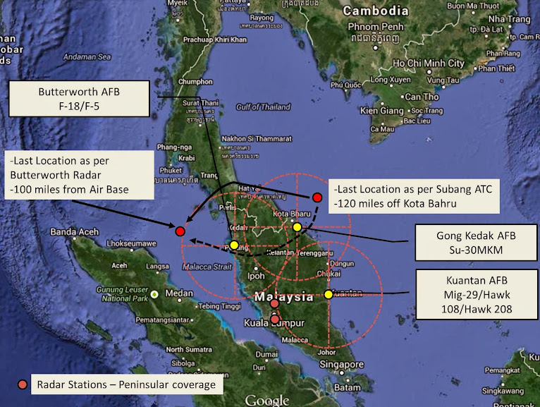
The circles out of AFB represent 200 km radius for radar coverage.
The last sited position of plane as per Subang ATC was 120 miles off the coast of Kota Bahru at 1:30 am while the latest news talks about RMAF radar out of Butterworth showing final position at 2:40am over western part of Malacca Strait.
1. A very important question which needs to be answered is how come the military radars did not pick-up this aircraft – which would have been an UFO for them – and intercept it as it turned back from its last location off the Malaysian coast? If you see the map above, couple of things strike you very clearly:
a. How did the aircraft manage to go from east coast to west coast by overflying the Malaysian territory and over a flight path which would be close to its border with Thailand and between air force bases and border?
b. One would expect that had it turned back and entered the Malaysian east coast, it would have been picked up by military radars at their Gong Kedak AFB and intercepted by their Su-30MKM squadron based there.
c. Secondly, the direct distance between Butterworth AFB and east coast is 300 km; the radar at Butterworth should have picked up the aircraft much before as it would have been flying over the Malaysian hinterland as a non-scheduled aircraft over airspace not open to civilian traffic. This radar picked up the last location of a/c over Pulau Perak Island which is 160 km from towards west of the base – had the a/c being flying from east-to-west coast over the Malaysian hinterland, it would have tracked it from almost 200 km afar.
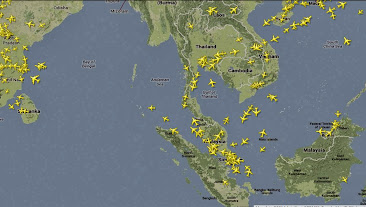
This this screen-shot from flightradar24.com – you can see no air-traffic in east-west direction in area towards Malaysia-Thailand border.
d. And had Butterworth picked up the unidentified aircraft, it too could/would have scrambled F-18 based there for interception/visual identification.
e. Flying at 800 km per hour, the MH370 would have been flying for 30+ minutes over Malaysian airspace had it entered through east coast and exited through west coast. And I don’t think RMAF is incompetent to allow a large body aircraft like Boeing 777 to fly undetected and without interception over its airspace. If that be the case, they may as well sell their planes and outsource the air defense to someone else.
Based on above assertion, two possibilities arise:
1. The aircraft switched off the transponder and took a flight path which would have taken it over the Thailand territory. I looked up the air force bases of Royal Thailand Air Force and they are situated in the main heartland (along with few fighter squadrons they have) and this area is bereft of any airbase. Though, it would not be possible to rule out presence of radars close to the border.
This way, while the RMAF could have tracked the aircraft inside Thai airspace, it would not have known the type or make of the aircraft. Further, since Langkawi falls towards north-west and would be covered by radar out of Butterworth, the airliner continued to fly outside Malaysian airspace w/o interception by the RMAF.
When the news broke about missing Malaysian airliner, someone in RMAF would have sent the data-point to higher ups about UFO which flew over Thailand and was tracked by RMAF radar units. It would have been a case of putting 2 and 2 together and that is why it took time – the RMAF and other authorities would have checked and double checked before making this assertion. The entire flight path would have been known to RMAF radar crew and that is how they managed to tell that it was flying 1,000 meter lower than earlier altitude.
2. That Malaysia allowed the a/c to travel over it’s airspace – there could have been a high jacking with high-jack crew demanding the plane be taken to location X in west and was allowed to proceed. RMAF kept a watch and then something drastic, or desperate, happened over Malacca Straits leading to a/c going down. The song-and-dance of missing flight could be to mask this aspect – though, honestly, I doubt a nation would go to such extent.