Mangalyaan: ISRO's Mars Orbiter Mission
-
member_28108
- BRFite
- Posts: 1852
- Joined: 11 Aug 2016 06:14
Re: Mangalyaan : ISRO's Mars Orbiter Mission
Last edited by member_28108 on 03 Oct 2014 07:28, edited 2 times in total.
Re: Mangalyaan : ISRO's Mars Orbiter Mission
@MarsOrbiter just replied back to prasannasimha Saar 
-
member_28108
- BRFite
- Posts: 1852
- Joined: 11 Aug 2016 06:14
Re: Mangalyaan : ISRO's Mars Orbiter Mission
How does one post a tweet on this thread.I tried to post the actual tweet but it doesn't work.SagarAg wrote:@MarsOrbiter just replied back to prasannasimha Saar
Re: Mangalyaan : ISRO's Mars Orbiter Mission
Good work, prasanna ji!prasannasimha wrote:https://twitter.com/MarsOrbiter/status/ ... 5365358592
Re: Mangalyaan : ISRO's Mars Orbiter Mission
SaiK wrote:that means the complete path from earth to mars, including those earth orbits, trans orbits, and mars orbits are part of the normal behavior model. but the most important aspect here how does the spacecraft determine its current position given a model or derive its current position to know the deviations?The orbiter has sensors and transmitters that may sense “misbehaviour” and change over to the redundant system by itself.
http://igiri.org/health/orbiter-autonom ... n-the-day/
how do they do this?
i am assuming the path corrections are included here (just keeping redundancy aside for high availability needs - or this is the case of redundant dissimilar system for the same functional objective)
--------------
mil objective: the same system can be used for launch detection of global satellites from massa, russia, eu and china, and early determination of the flight path deviations meaning predicting the target destination within certain acceptable delta-time.. if path corrections, and determination of incorrect flight path corresponds to various launch profile and signature, and online validating the launch with schedule launch to quickly determine that is a first strike by an enemy nation. the second strike under nfu, launches from desh can begin while the first strike is in mid-course.
SaiK ji,that means the complete path from earth to mars, including those earth orbits, trans orbits, and mars orbits are part of the normal behavior model. but the most important aspect here how does the spacecraft determine its current position given a model or derive its current position to know the deviations?
how do they do this?
i am assuming the path corrections are included here (just keeping redundancy aside for high availability needs - or this is the case of redundant dissimilar system for the same functional objective)
Can't find the write up now, even though I searched for it.
Something about MOM taking a series of pictures of very distant stars at extremely short time intervals and then comparing the same with pictures stored on board to compute desired path with actual path.
Course correction if any would thus be managed by its autonomous nav system.
-
member_28108
- BRFite
- Posts: 1852
- Joined: 11 Aug 2016 06:14
Re: Mangalyaan : ISRO's Mars Orbiter Mission
http://www.scientificamerican.com/artic ... bes-navig/
How do space probes navigate large distances with such accuracy and how do the mission controllers know when they've reached their target?
Mar 27, 2006
Jeremy Jones, chief of the navigation team for the Cassini Project at NASA's Jet Propulsion Laboratory, offers this explanation.
The accurate navigation of space probes depends on four factors: First is the measurement system for determining the position and speed of a probe. Second is the location from which the measurements are taken. Third is an accurate model of the solar system, and fourth, models of the motion of a probe.
For all U.S. interplanetary probes, the antennas of the Deep Space Network (DSN) act as the measurement system. These antennas transmit radio signals to a probe, which receives these signals and, with a slight frequency shift, returns them to the ground station. By computing the difference between the transmitted and received signals, a probe's distance and speed along the line from the antenna can be determined with great accuracy, thanks to the high frequency of the signals and a very accurate atomic clock by which to measure the small frequency changes. By combining these elements, navigators can measure a probe's instantaneous line-of-sight velocity and range to an accuracy of 0.05 millimeter-per-second and three meters respectively, relative to the antenna.
Many probes also carry cameras that are used to image the destination, whether it be a moon, planet or other body. During the final approach, these images are used when the distance becomes small. For example, the Cassini spacecraft's camera provides an angular measurement with an accuracy of three microradians (three kilometers) at a distance of one million kilometers. The images complement the radio data and provide a direct tie to the target.
Calculation of the trajectory of a space probe requires the use of an inertial coordinate system as well, wherein a grid is laid over the solar system and fixed relative to the star background. For interplanetary missions, an inertial coordinate system with an origin at the center of mass of the solar system is used. Because the measurements provide information on the position of a probe relative to the antenna, knowledge of the antenna's location relative to this inertial coordinate system is used to convert the measurements into elements in the system. Where the antenna is depends not only on its geographic location on Earth's surface, but on Earth's position relative to the solar system center of mass (known as the Earth ephemeris). Measurements of this ephemeris have an accuracy of about 0.5 kilometer and the location of the antenna is known to an accuracy of better than five centimeters.
The third component of interplanetary navigation is an accurate model of the solar system. Gravity is the most important force acting on a spacecraft. Determining these gravitational forces requires accurate knowledge of the locations of all of the major bodies, such as the sun and all the planets, over the course of time. This information is provided by the planetary ephemeris, which has been in continuous development since the beginning of the interplanetary space program. Thanks to this longstanding work, the location of Saturn was known to an accuracy of a few hundreds of kilometers previous to Cassini's final approach when it deployed its camera. After the probe entered Saturn orbit, the moons of the giant planet became important gravitational bodies. Their locations have been determined to an accuracy of a few kilometers relative to Saturn.
The final component of accurate navigation takes all of these other elements and, using models of the forces acting on a probe and orbital dynamics, estimates its location. By taking regular measurements over a period of time, a probe's position and velocity can be determined. For example, Cassini's location is typically determined to a kilometer or less relative to Saturn. Using a probe's known position and velocity, its future positions can be worked out. Navigators compare these positions to the predicted location of the target body--based on the ephemeris--to determine when a probe will reach its target. Then, all that's left to do is to collect the flyby data, take a deep breath, and go on to the next encounter.
Re: Mangalyaan : ISRO's Mars Orbiter Mission
radar return time is definitely an option, but that is done from the earth observation point. it would be expensive to have it on board, and nearly not possible to devote energy towards that.
angular measures are good, but as long as objects can be easily mapped and identified by some unique signature. i guess the clutter is negligible since we know exactly the direction at the time of launch, and moon and mars relatively well known. a redundant system to kick-in, it has to have some initial state, current state and the target/eventual state to reach.
still confusing/not clear how it does it.. accurate model of the solar system is definitely required.
Re: Mangalyaan : ISRO's Mars Orbiter Mission
It looked like that they had chosen a set of stars very very far away so that the relative position remained almost constant because of the great distance. They did not use any model of the solar system itself but the position of a specific set of stars as the reference.SaiK wrote:radar return time is definitely an option, but that is done from the earth observation point. it would be expensive to have it on board, and nearly not possible to devote energy towards that.
angular measures are good, but as long as objects can be easily mapped and identified by some unique signature. i guess the clutter is negligible since we know exactly the direction at the time of launch, and moon and mars relatively well known. a redundant system to kick-in, it has to have some initial state, current state and the target/eventual state to reach.
still confusing/not clear how it does it.. accurate model of the solar system is definitely required.
This article had come out on the day of the MOM's mars insertion. Maybe someone has the reference.
-
member_28108
- BRFite
- Posts: 1852
- Joined: 11 Aug 2016 06:14
Re: Mangalyaan : ISRO's Mars Orbiter Mission
Reposting from MOM thread
-
member_28108
- BRFite
- Posts: 1852
- Joined: 11 Aug 2016 06:14
Re: Mangalyaan : ISRO's Mars Orbiter Mission
They typically use star sensors to determine position. By triangulating the position using multiple stars the position can be calculated.SaiK wrote:radar return time is definitely an option, but that is done from the earth observation point. it would be expensive to have it on board, and nearly not possible to devote energy towards that.
angular measures are good, but as long as objects can be easily mapped and identified by some unique signature. i guess the clutter is negligible since we know exactly the direction at the time of launch, and moon and mars relatively well known. a redundant system to kick-in, it has to have some initial state, current state and the target/eventual state to reach.
still confusing/not clear how it does it.. accurate model of the solar system is definitely required.
Ranging is done by Delta DOR.
Prasanna
-
member_28108
- BRFite
- Posts: 1852
- Joined: 11 Aug 2016 06:14
Re: Mangalyaan : ISRO's Mars Orbiter Mission
Mars Orbiter Mission looks to sniff methane on comet
Chethan Kumar, TNN | Sep 26, 2014, 05.39AM IST
mom-isro-picture
Radhakrishnan said MOM has 40kg of fuel left as against the 20 kg that was thought necessary for its predicted six-month life span. (Picture courtesy Isro)
BANGALORE: India's Mars Orbiter Mission (MOM) will look to have a date with the Siding Spring comet, which will pass very close to the Red Planet on October 19, Isro chairman K Radhakrishnan said on Thursday.
A committee headed by former Isro chairman U R Rao will decide what kind of study should be carried out. But MOM will definitely examine if the comet has methane. "We all know there is enough water and methane on comets. So that will be one thing we will look for it," Radhakrishnan told TOI.
The Rao-headed Advisory Committee for Space Sciences has not met yet because MOM has not completed the orbit around Mars and scientists don't know its exact position. "We'll know the exact details only when MOM completes the entire orbit/ellipse. We know the position of the comet on October 19, but we can only determine what we can do based on where our spacecraft is," he said.
"We've done our job," the Isro chief said on the success of the Mars mission at Isro's first attempt.
Radhakrishnan said MOM has 40kg of fuel left as against the 20 kg that was thought necessary for its predicted six-month life span. This indicates that the orbiter may have a longer life than thought.
Isro's scientific secretary V Koteswara Rao had said that if MOM can weather the solar eclipse expected to occur in the Martian orbit in April-May 2015, and maintain its health and course, its life expectancy will increase by a few weeks, allowing India to probe more.
Asked how Nasa could do reprogramming on its MAVEN spacecraft to study the comet, Radhakrishnan said: "MAVEN reached there before us and has completed the orbit around the Red Planet. I have received mails about what they are going to do, and we know what we should. But MOM has to ascertain its position. It will be known in 2-3 days."
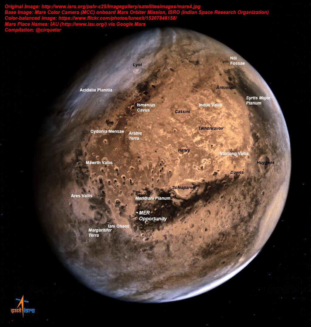
The colour camera aboard the spacecraft sent five photographs on Wednesday, hard copies of which were handed over to Prime Minister Narendra Modi on Thursday.
Chethan Kumar, TNN | Sep 26, 2014, 05.39AM IST
mom-isro-picture
Radhakrishnan said MOM has 40kg of fuel left as against the 20 kg that was thought necessary for its predicted six-month life span. (Picture courtesy Isro)
BANGALORE: India's Mars Orbiter Mission (MOM) will look to have a date with the Siding Spring comet, which will pass very close to the Red Planet on October 19, Isro chairman K Radhakrishnan said on Thursday.
A committee headed by former Isro chairman U R Rao will decide what kind of study should be carried out. But MOM will definitely examine if the comet has methane. "We all know there is enough water and methane on comets. So that will be one thing we will look for it," Radhakrishnan told TOI.
The Rao-headed Advisory Committee for Space Sciences has not met yet because MOM has not completed the orbit around Mars and scientists don't know its exact position. "We'll know the exact details only when MOM completes the entire orbit/ellipse. We know the position of the comet on October 19, but we can only determine what we can do based on where our spacecraft is," he said.
"We've done our job," the Isro chief said on the success of the Mars mission at Isro's first attempt.
Radhakrishnan said MOM has 40kg of fuel left as against the 20 kg that was thought necessary for its predicted six-month life span. This indicates that the orbiter may have a longer life than thought.
Isro's scientific secretary V Koteswara Rao had said that if MOM can weather the solar eclipse expected to occur in the Martian orbit in April-May 2015, and maintain its health and course, its life expectancy will increase by a few weeks, allowing India to probe more.
Asked how Nasa could do reprogramming on its MAVEN spacecraft to study the comet, Radhakrishnan said: "MAVEN reached there before us and has completed the orbit around the Red Planet. I have received mails about what they are going to do, and we know what we should. But MOM has to ascertain its position. It will be known in 2-3 days."
The colour camera aboard the spacecraft sent five photographs on Wednesday, hard copies of which were handed over to Prime Minister Narendra Modi on Thursday.
-
Mort Walker
- BRF Oldie
- Posts: 10442
- Joined: 31 May 2004 11:31
- Location: The rings around Uranus.
Re: Mangalyaan : ISRO's Mars Orbiter Mission
^^^I find it odd that they release the photos to the PMO, then go public. Perhaps ISRO is deferring to the PM to ensure future agency funding. Ideally this is for scientific uses and as such ISRO MOM team should look at the images and then decide when to publish them.
-
member_28108
- BRFite
- Posts: 1852
- Joined: 11 Aug 2016 06:14
Re: Mangalyaan : ISRO's Mars Orbiter Mission
I think they have shown the first set of images and for the photop. I don't think they would have the time or the energy to keep sending those images to the PMO. I don't think Modi would have the time nad the energy to digest all that data (Terabytes) either.Mort Walker wrote:^^^I find it odd that they release the photos to the PMO, then go public. Perhaps ISRO is deferring to the PM to ensure future agency funding. Ideally this is for scientific uses and as such ISRO MOM team should look at the images and then decide when to publish them.
-
member_28108
- BRFite
- Posts: 1852
- Joined: 11 Aug 2016 06:14
Re: Mangalyaan : ISRO's Mars Orbiter Mission
One of the funny "advantages" of the extreme eccentricity of the orbit is that it has allowed full disc images of Mars that have never been obtained before and so fatr the best images had been by Hubble. The details are more clear with the MOM mission. The payload and orbital limitations have turned out to making the best of what was a disadvantage. 
-
member_28108
- BRFite
- Posts: 1852
- Joined: 11 Aug 2016 06:14
Re: Mangalyaan : ISRO's Mars Orbiter Mission
Why we need to have a long term vision and invest in science including space exploration. The dividends are humongous in the long term. Short term perspectives will be precisely that short term.
Re: Mangalyaan : ISRO's Mars Orbiter Mission
^^^
1.This ( image presentation and attempting SS imaging ) is an old news item .. before MOM completed first orbit.
2. The sending of signal and receiving back that has been referred in one of the post is not Radar type of passive reflection.
It refers to Ranging by measuring the doppler shift ( DSN transmits signal .. satellite receives it .. amplifies it and transmits back the signal .. DSN receives it and measures the phase difference between sent signal and received signal ) this represents the time delay which in turn denotes the distance.
3. the frequency difference denotes relative speed between the two objects.
-
member_28108
- BRFite
- Posts: 1852
- Joined: 11 Aug 2016 06:14
Re: Mangalyaan : ISRO's Mars Orbiter Mission
Attitude and Orbit Control System AOCE (Attitude and Orbit Control Electronics): with MAR31750 Processor
Sensors: Star sensor (2Nos), Solar Panel Sun Sensor (1No), Coarse Analogue Sun Sensor
Actuators: Reaction Wheels (4Nos), Thrusters (8Nos), 440N Liquid Engine
There are two Star Sensors for determining position of the craft.
http://www.isro.org/mars/spacecraft.aspx
Nice information on space craft sensors at
http://www.princeton.edu/~stengel/MAE342Lecture13.pdf
Re: Mangalyaan : ISRO's Mars Orbiter Mission
Lot of nice posts.. catching up.. few quick points
(So much so, that at one time people really thought these were beacons placed by intelligent life)
Voyager spacecrafts had "map of a few reference pulsars" so that if the spacecraft is found by an intelligent species, one can locate the source (solar system/earth) and time when the space-craft was launched.
In MOM's case, the quasars are used (Remarkable since one quasar being used by MOM and ground station is 50 million light-years away! - it is one of the "brightest" object in the known universe - one has been used not unlike "beacon" before by other space-crafts too)
Any way, just the physics/math fundamental part - Here is how it is used.
- MOM's signal is caught simultaneously by two ground stations (say Goldstone and Canberra)
- One finds the time difference (or time delay) between signal arriving at these two stations. (Not unlike the example I gave before - car GPS finding delay time between two GPS stations).
- This (along with round trip travel time and Doppler data) can give very good accuracy.
- Problem is these waves travel through different paths and error can be introduced by troposphere/ionosphere etc of earth which are difficult to estimate.
- This is where a quasar enters in the picture. One chooses a quasar which is almost in the same direction of MOM (10-15 degrees off will not matter, as long as it is approximately in the same direction.
- Now one can correct for the difference caused by temp conditions of troposphere/ionosphere- looking at the reference data from quasar.
(Thus typical accuracy for angle-measurement for MOM is, no I am not kidding, nano-radian)
Yes, Quasars/pulsars are extremely stable directional as well as timing devices (very stable indeed- comparable to atomic clocks).matrimc wrote:AmberG: Are there any natural sources like Quasars or pulsars or other kinds of radiation which would be available in the vacuum of space or there is nothing but white noise in space?
(So much so, that at one time people really thought these were beacons placed by intelligent life)
Voyager spacecrafts had "map of a few reference pulsars" so that if the spacecraft is found by an intelligent species, one can locate the source (solar system/earth) and time when the space-craft was launched.
In MOM's case, the quasars are used (Remarkable since one quasar being used by MOM and ground station is 50 million light-years away! - it is one of the "brightest" object in the known universe - one has been used not unlike "beacon" before by other space-crafts too)
Any way, just the physics/math fundamental part - Here is how it is used.
- MOM's signal is caught simultaneously by two ground stations (say Goldstone and Canberra)
- One finds the time difference (or time delay) between signal arriving at these two stations. (Not unlike the example I gave before - car GPS finding delay time between two GPS stations).
- This (along with round trip travel time and Doppler data) can give very good accuracy.
- Problem is these waves travel through different paths and error can be introduced by troposphere/ionosphere etc of earth which are difficult to estimate.
- This is where a quasar enters in the picture. One chooses a quasar which is almost in the same direction of MOM (10-15 degrees off will not matter, as long as it is approximately in the same direction.
- Now one can correct for the difference caused by temp conditions of troposphere/ionosphere- looking at the reference data from quasar.
(Thus typical accuracy for angle-measurement for MOM is, no I am not kidding, nano-radian)
Re: Mangalyaan : ISRO's Mars Orbiter Mission
AmberG: Thanks. One doubt still remains - how do you get the original reference of the quasar in question? All this data is in some database from previous satellites measurements, I suppose. The resolution is amazing. My first thought was "is it even possible?". Wow bloody wow.
I think it would be really useful to list all the principles involved from the different disciplines (I will go from the abstract to the concrete) Mathematics, Mathemtaical Physics/Chemistry, Physics, Chemistry, Biology, Engineering, Computational Physics/Chemistry/Biology/Engineering, Manufacturing, Civil Engg., and Project Management.
GopiN: Please start the thread so that we can start listing what has been mastered by ISRO and other Indian orgs involved in the MOM project to achieve the feat. Also what other technologies need to be mastered before manned mission to moon?
-
member_28108
- BRFite
- Posts: 1852
- Joined: 11 Aug 2016 06:14
-
member_24146
- BRFite -Trainee
- Posts: 30
- Joined: 11 Aug 2016 06:14


Re: Mangalyaan : ISRO's Mars Orbiter Mission
prasanna saar, I want you to not consider any earth based installations in the game of positioning. Assume the space craft is lost in space without any signals from Earth. That was my earlier question.. context: redundant autonomy system that should act independently and correct misbehavior. I think, we are missing a lot of scope from these discussions, but we need to reverse engineer/[deep dive into what could be the design] from the advertized capabilities.
-
member_28108
- BRFite
- Posts: 1852
- Joined: 11 Aug 2016 06:14
Re: Mangalyaan : ISRO's Mars Orbiter Mission
There is a star sensor for more accurate placement and there is the sun sensor to give coarse position during the heliocentric phase.Those are used for finding the position but they need to reconfirm with earth based measurements when the perform a Trajectory Control maneuver.They were aware of the difference from predicted course and I think allowed a greater drift to allow for a particular planned mode of burn with the eight thrusters as a plan B if plan A had not worked out. For that they needed to be at a higher distance to allow it for a capture orbit with a higher apogee.SaiK wrote:prasanna saar, I want you to not consider any earth based installations in the game of positioning. Assume the space craft is lost in space without any signals from Earth. That was my earlier question.. context: redundant autonomy system that should act independently and correct misbehavior. I think, we are missing a lot of scope from these discussions, but we need to reverse engineer/[deep dive into what could be the design] from the advertized capabilities.
-
member_28108
- BRFite
- Posts: 1852
- Joined: 11 Aug 2016 06:14
Re: Mangalyaan : ISRO's Mars Orbiter Mission
Actually one of the things used by some of the ICBM's when they launch and enter space is to activate the star sensors apart from inertial guidance RINGS and MINGS etc.
All these ICBM's follow a ballistic trajectory and I am not sure but once they are in the atmospheric renetry due to the "plasma sheath" there may be a communication backout which is why MaRV is a difficult thing to design as it needs a high level autonomy and trajectory prediction and reorientation or else everyone would be ahving rockets doing swirling maneuvers like some Deepavali rockets and hitting a hole in one.!
All these ICBM's follow a ballistic trajectory and I am not sure but once they are in the atmospheric renetry due to the "plasma sheath" there may be a communication backout which is why MaRV is a difficult thing to design as it needs a high level autonomy and trajectory prediction and reorientation or else everyone would be ahving rockets doing swirling maneuvers like some Deepavali rockets and hitting a hole in one.!
Re: Mangalyaan : ISRO's Mars Orbiter Mission
MatrimC, many may not know this but Yes, a few hundred quasars (and some similar objects) make up the most important reference system (see below) Because they are extremely distant, bright, and small in apparent size, they are extremely useful reference points. (They are so far away they can be considered fixed or stationary (even with best technology), yet the position has been measured with utmost accuracy (much better than optical telescopes), using VLBI's - They now make the MOST important part of navigational charts, stored in computers (or tables) of all astronomers, space probes and the like.matrimc wrote:AmberG: Thanks. One doubt still remains - how do you get the original reference of the quasar in question? All this data is in some database from previous satellites measurements, I suppose. The resolution is amazing. My first thought was "is it even possible?". Wow bloody wow.
Actually, ICRS (International Celestial Reference System), the standard all use, is defined in this way.
Yes, the every day coordinates we all use ( "hour angle", and "declination" of any star (or planet or MOM's) position) is NOW defined this way. (So celestial pole, for example which denotes N-S axis of the earth - is actually defined by ICRS by using quasars because there is too much uncertainty in "wobble" of earth spin axis.
(Check out wiki entry for ICRS -http://en.wikipedia.org/wiki/Internatio ... nce_System
From the above, worth reading:
The International Celestial Reference Frame (ICRF) is a quasi-inertial reference frame centered at the barycenter of the Solar System, defined by the measured positions of 212 extragalactic sources (mainly quasars). Although general relativity implies that there are no true inertial frames around gravitating bodies, the ICRF is important because it definitely does not exhibit any measurable angular motion since the extragalactic sources used to define the ICRF are so far away. The ICRF is now the standard reference frame used to define the positions of the planets (including the Earth) and other astronomical objects. It has been adopted by International Astronomical Union since 1 January 1998. ICRF had a noise floor of approximately 250 microarcseconds (µas) (AmberG Note: current values/standard this is reduced to about 40 - that is, 40*10^(-6) arc seconds!!!- less than nano-radian) and an axis stability of approximately 20 µas; this was an order-of-magnitude improvement over the previous Fifth Fundamental Catalog (FK5).[1]
-
Mort Walker
- BRF Oldie
- Posts: 10442
- Joined: 31 May 2004 11:31
- Location: The rings around Uranus.
Re: Mangalyaan : ISRO's Mars Orbiter Mission
^^^What does it mean by a noise floor of 250 uas? The thermal noise measured within that defined angular resolution when pointed toward the center of the solar system? To me noise is power or energy and not angular resolution. It seems I'm missing something?
-
member_28108
- BRFite
- Posts: 1852
- Joined: 11 Aug 2016 06:14
Re: Mangalyaan : ISRO's Mars Orbiter Mission
it is a number that refers to the "noise" or jitter (not a correct example) in measurement where noise refers to any other signal than the one which needs to be measured.Mort Walker wrote:^^^What does it mean by a noise floor of 250 uas? The thermal noise measured within that defined angular resolution when pointed toward the center of the solar system? To me noise is power or energy and not angular resolution. It seems I'm missing something?
let us assume that there is a background noise from which a signal emeanates.If the signal is smaller than the established basal noise you cannot measure that signal by conventional techniques- something like you have to shout to be heard in a noisy room.
-
Mort Walker
- BRF Oldie
- Posts: 10442
- Joined: 31 May 2004 11:31
- Location: The rings around Uranus.
Re: Mangalyaan : ISRO's Mars Orbiter Mission
Noise units are Watts and Noise Temperature units are Watts/Hz = Joules. Noise Floor is typically described as Watts(dBm)/Hz. My guess is that Noise Floor in the context of the ICRF has to do with pointing accuracy.
The cosmic background noise temperature is 2.7 K as the reference.
The cosmic background noise temperature is 2.7 K as the reference.
-
member_28108
- BRFite
- Posts: 1852
- Joined: 11 Aug 2016 06:14
Re: Mangalyaan : ISRO's Mars Orbiter Mission
This is not noise of electromagnetic waves but noise in determination of celestial reference system (barycenter of the sun is used as the reference point.
Re: Mangalyaan : ISRO's Mars Orbiter Mission
Mortji and others,
I know the original quote about "noise" is from wiki reference, so perhaps it's meaning may be less technical and it is just saying that the uncertainty is of the order of 1 in 10^10, but I think Mort's point is on the dot. The measurements are done using Very Long Baseline Interferometry (VLBI) (Very similar in principal to ΔDOR people have talked here before), and this is directly related to S/N for the receiving stations as in noise of electromagnetic waves)
(For me, it is amazing that perhaps NGC 4438, which is 50 million light-years away, helped pinpoint MOM to an accuracy of about 1 meter from antennas placed on Earth.. and it's speed within 3 meters per hour - 1 mm/sec)... think about that folks.)
Last edited by Amber G. on 03 Oct 2014 22:21, edited 1 time in total.
-
member_28108
- BRFite
- Posts: 1852
- Joined: 11 Aug 2016 06:14
Re: Mangalyaan : ISRO's Mars Orbiter Mission
In signal theory, the noise floor is the measure of the signal created from the sum of all the noise sources and unwanted signals within a measurement system, where noise is defined as any signal other than the one being monitored.
http://en.wikipedia.org/wiki/Noise_floor
There are different kinds of noise and this is important.You are referring to noise in relation to electromagnetic waves but that is one form of noise. Noise can also be there wrt measurements for example the background noise in EEG signals or ECG signals can interfere with interpretation and placement of filters to remove this can be an issue.Similarly in making position markings there can be a noise wrt rotation wrt stabilty of frames of reference.
Re: Mangalyaan : ISRO's Mars Orbiter Mission
Sorry if already posted here or on official site, but is there any official word on MOM's plan to be ready for Siding Spring.
Heard that, isro will finalize a plan and decide, in a day or so, if they wan to use some of the fuel for orbit manipulation to get better look at the comet.
Heard that, isro will finalize a plan and decide, in a day or so, if they wan to use some of the fuel for orbit manipulation to get better look at the comet.
-
member_28108
- BRFite
- Posts: 1852
- Joined: 11 Aug 2016 06:14
Re: Mangalyaan : ISRO's Mars Orbiter Mission
The news that I read was they were waiting for some time to confirm all orbital parameters and then the team headed by Dr UR Rao will finalize the plans.Amber G. wrote:Sorry if already posted here or on official site, but is there any official word on MOM's plan to be ready for Siding Spring.
Heard that, isro will finalize a plan and decide, in a day or so, if they wan to use some of the fuel for orbit manipulation to get better look at the comet.
-
Mort Walker
- BRF Oldie
- Posts: 10442
- Joined: 31 May 2004 11:31
- Location: The rings around Uranus.
Re: Mangalyaan : ISRO's Mars Orbiter Mission
What is amazing is that the sun and moon are 1/2 degree or 1800 arc-seconds, so 250 uas is very very small.Amber G. wrote:Mortji and others,
I know the original quote about "noise" is from wiki reference, so perhaps it's meaning may be less technical and it is just saying that the uncertainty is of the order of 1 in 10^10, but I think Mort's point is on the dot. The measurements are done using Very Long Baseline Interferometry (VLBI) (Very similar in principal to ΔDOR people have talked here before), and this is directly related to S/N for the receiving stations as in noise of electromagnetic waves)
(For me, it is amazing that perhaps NGC 4438, which is 50 million light-years away, helped pinpoint MOM to an accuracy of about 1 meter from antennas placed on Earth.. and it's speed within 3 meters per hour - 1 mm/sec)... think about that folks.)
About noise. I thought engineers were bad, so I guess astrophysicists are just as bad.
Re: Mangalyaan : ISRO's Mars Orbiter Mission
Excellent post. Very succinct and useful .. Let me add one important oscillator here, to make it complete.Mort Walker wrote: About clocks. A clock is essentially an oscillator. The quality of an oscillator is defined by frequency accuracy, phase noise, and jitter. Phase noise is the noise level within a 1 Hz bandwidth at some frequency offset from the main frequency. If phase noise is too high, that is the noise level is higher in amplitude than the main frequency, the oscillator can not resolve its main frequency with accuracy. Jitter is a function of phase noise at some offset frequency. Really, no oscillator can be more accurate than its phase noise level which is governed by the thermal noise floor - unless it is cooled by an external source, remember Boltzman's Constant and temperature. Amberji can give a lesson in statistical mechanics to explain this.
The best oscillators in rank are:
1. NIST reference laser which works in a lab environment and is very expensive. Not applicable for commercial use or aerospace/defense applications.
2. Cesium atomic clock. Very accurate to the thermal noise floor. Expensive and are in GPS satellites. They need good current and voltage, and are heavy. Not applicable to MOM due to weight.
3. Rubidium clock. Accuracy 10^-11 sec. Commercially available for around $2K and are used as reference clocks for communication systems and computer networks. If I were designing MOM, I would consider using a rubidium clock.
4. Oven Controlled Crystal Oscillator (OCXO). Accuracy 10^-9 sec. Commercially available and very compact, less than $200. These are used at the board level on aircraft, missiles, and off-the-shelf test equipment. Ideal for MOM as it is light weight, requires less power and very inexpensive.
5. The remaining would be voltage controlled oscillators, crystal oscillators and PLLs. But these would be less than ideal as accuracy would be around 10^-6 to 10^-7 seconds.
1.9 or 2.1 - Pulsars -
- These are neutron stars, which emit radio pulses, (mainly due to the fact that they are spinning or revolving) some as stable as (or better than) atomic clocks.
In some ways these may be more useful than atomic clocks, as they are natural, already exist, and can be used from any place in the solar system (or beyond). But these are not that popular yet.
There are only a few accurate "pulsar clocks" commercially in the world at present, and space probes do not use these devices, mainly i guess, because they will need a rather large radio antenna - beside we already have a good earth based atomic clocks. (perhaps probes outside Mars will find it more cost effective).
(For physicists - pulsar based time is more "gravity force based" (Ephemeris time), while atomic clocks and all other mentioned in Mort's post are based on "nuclear forces' (atomic time)) - so these are of very interest to physicists to see the relationship between these two fundamental forces)
-
Bade
- BRF Oldie
- Posts: 7212
- Joined: 23 May 2002 11:31
- Location: badenberg in US administered part of America
Re: Mangalyaan : ISRO's Mars Orbiter Mission
http://www.nasa.gov/topics/technology/f ... gxnlt.html
Pulsars offer a potentially revolutionary navigational solution because of their rapid rotation and the powerful beams of light that emanate from their magnetic poles. On Earth, these beams are seen as flashes of light, blinking on and off as the pulsar rotates into view. Because of their predictable pulsations, they can provide high-precision timing just like the atomic-clock signals supplied through the 26-satellite, military-operated GPS.
However, unlike GPS signals, which are geared to Earth-based applications, pulsars are accessible in virtually every conceivable flight regime, from low-Earth to interplanetary science, making the technology ideal for travel throughout the solar system and beyond.
From its berth on the International Space Station, the NICER/SEXTANT instrument will use its 56 bundled X-ray telescopes, silicon detectors and other advanced technologies to detect X-ray photons in the pulsars' powerful beams of light to estimate their arrival times. With these measurements, the system will stitch together an onboard, completely autonomous navigational solution using specially developed algorithms.
Re: Mangalyaan : ISRO's Mars Orbiter Mission
Interesting part for me would be, how much (if any) of the "extra fuel" they are ready to use to get a better view. Very tough decision.prasannasimha wrote: The news that I read was they were waiting for some time to confirm all orbital parameters and then the team headed by Dr UR Rao will finalize the plans.
-
member_28108
- BRFite
- Posts: 1852
- Joined: 11 Aug 2016 06:14
Re: Mangalyaan : ISRO's Mars Orbiter Mission
Another issue is whether they have to alter their orbit to avoid particles in the comet tail that could damage the probes.
Re: Mangalyaan : ISRO's Mars Orbiter Mission
This, I don't think is a problem. Of course, no one knows for sure, as no one has any more detail data about SS but from best models about "particles flux", that from my rough calculation the chances that *any single * particle, will hit MOM is about 1 in 300,000 (or much less), and altering the orbit does not really change that number.prasannasimha wrote:Another issue is whether they have to alter their orbit to avoid particles in the comet tail that could damage the probes.
Re: Mangalyaan : ISRO's Mars Orbiter Mission
Bade Thanks. There are many pulsars emitting EM radiation in different frequencies, so x-ray pulsars, will not need large radio antenna.Bade wrote:http://www.nasa.gov/topics/technology/f ... gxnlt.htmlPulsars offer a potentially revolutionary navigational solution because of their rapid rotation and the powerful beams of light that emanate from their magnetic poles. On Earth, these beams are seen as flashes of light, blinking on and off as the pulsar rotates into view. Because of their predictable pulsations, they can provide high-precision timing just like the atomic-clock signals supplied through the 26-satellite, military-operated GPS.
However, unlike GPS signals, which are geared to Earth-based applications, pulsars are accessible in virtually every conceivable flight regime, from low-Earth to interplanetary science, making the technology ideal for travel throughout the solar system and beyond.
From its berth on the International Space Station, the NICER/SEXTANT instrument will use its 56 bundled X-ray telescopes, silicon detectors and other advanced technologies to detect X-ray photons in the pulsars' powerful beams of light to estimate their arrival times. With these measurements, the system will stitch together an onboard, completely autonomous navigational solution using specially developed algorithms.
Interesting tid bit, when they were first discovered , people believed that it has to be coming from intelligent life. The name given then, LGM stuck. (LGM stood for "Little Green Man
Also, in the interstellar probe, Voyager, the plaque (see image below) contained the "map of pulsars" so that, when it is found by alien life, one can still deduct that it came from one particular part of the Universe, and particular year in it's life..
Here are two images of the plaque..
Image i
And some description:
image 2
Last edited by Amber G. on 04 Oct 2014 01:18, edited 3 times in total.