The language of the announcement is interesting. The words used are "flight ended", "plane plunged" in SIO. Add to this the claim that electronic data suggests there were no survivors.
So the passengers died much earlier even as the plane flew on ? How ? Decompression, the altitude of 45,000 ft, use of gas or fiddling with the cabin pressure controls ? What out of all these can be ruled in or out with electronic data ?
Would the plane be able to fly on for hours even after decompression of the cabin ? No structural damage from it ?
Malaysian Airlines Flight MH-370 goes missing
-
Rajiv Lather
- BRFite
- Posts: 287
- Joined: 20 Sep 1999 11:31
- Location: Karnal, Haryana, India
Re: Malaysian Airlines Flight MH-370 goes missing
According to Inmarsat official interviewed on CNN and seen by me 30 minutes ago, Indian radar data ruled out Northern route.Singha wrote:so I dont see how this doppler thing rules out it landing safe n sound in some burmese warlords hideout, though I would imagine chinese moles would be shaking down that patch of woods (south of yunnan) very hard since the incident.
Re: Malaysian Airlines Flight MH-370 goes missing
Not sure why they called it Doppler shift. Would a plane that has flown 1000 km in 1 hour not respond to a ping sooner (or later) simply because of a change in distance (closer or further away). Over 6 hours the change in return of ping time would probably be noticeable. I mean don't EM waves travel 300 km in 1 msec, so 3000 km further would make the ping return time an eminently measurable 10 msec longer.Harpal Bector wrote: Generally doppler shifts in EM spectra tend to be quite small unless the object is moving very fast. If the ac was doing 900 kph the doppler shift would be very tiny 1e-7 level. To claim the ability to reliably see this level of shift one would need a clock that was stable at the 1e-9 level.Does the internal clock of the INMARSAT satellite have that stability over the course on an hour? over several hours?
Just shooting blindly in the dark here. No real knowledge.
Edited later - the satellite is 36,000 km up - so the ping return journey is 72,000 km when plane is directly below. For the same reason a plane that is 3000 km further would make the ping return journey 36000 + 3000 + 3000 + 36000 = 78,000 km - which is 6000 km more for the ping signal to travel for a 3000 km displacement of aircraft, in 6 hrs the aircraft would probably have travelled 5000 to 6000 km. along earth's curvature. The difference in time for the signal to return should be easy to measure.
-
member_28502
- BRFite
- Posts: 281
- Joined: 11 Aug 2016 06:14
Re: Malaysian Airlines Flight MH-370 goes missing
It can not have frequency shift as noted above
the ping can only have (or could have) time delay and even that would be in milli seconds
so its time "shift" of ping packets arrival and return trip getting (or taking) longer time to arrive and depart {at most like long distance conversations between Kristina Aman pours dumpings about Russia and on the field correspondents}
Re: Malaysian Airlines Flight MH-370 goes missing
They would not be. If the single EM source is far away (actually infinite distance), then only the EM rays would be tangential to the great circle. if one draws a line from the center of earth (and assume shape of earth to be a perfect sphere for simplicity, and the satellite is height h above the surface and earth's radius is r both of which are known) then one can calculate the circle of illumination. It would be a cross section which which lies in a plane whose outward normal is in the direction of the satellite assuming the center of the earth to be the origin.Lalmohan wrote:the two arcs are presumeably great circle 'straight lines'?
any real navigators know the answer to this?
Simple experiment with a globe and a flashlight will give the path. Of course everything to be appropriately scaled down in the proportion of R_e/R_g (earths radius over globes radius).
That said, if an object is moving within the illuminated area it would be possible to figure out the sign of the component of the displacement vector (think of a cone with the satellite at the apex and work in spherical coods with earth's center as the origin or satellite as the origin). If the sign does not change but the component magnitude is non-decreasing then one can figure out the approximate distance the object has traveled. The assumption here is that the object has not gone out of the area of this satellite above IO. If it has gone out of the area it would have to pass through an overlapping area which should give more information.
Last edited by Vayutuvan on 24 Mar 2014 21:58, edited 1 time in total.
-
member_28502
- BRFite
- Posts: 281
- Joined: 11 Aug 2016 06:14
Re: Malaysian Airlines Flight MH-370 goes missing
recall the experiments of Spherometer to find the radius of curvature of Lens? Intermediate 1 st year?

-
Harpal Bector
- BRFite
- Posts: 226
- Joined: 11 Aug 2016 06:14
Re: Malaysian Airlines Flight MH-370 goes missing
Okay that would not be a Doppler shift analysis but rather an analysis of the delay between sending and receiving of the ping, but what information does that give that isn't in the declination offset angle analysis shown before. If the a/c was moving away from the satellite the declination offset angle would keep increasing. There is nothing in that analysis that rules out a northern transit. I am not sure what analysis the Inmarsat people could present that would rule out the northern route based on their data collection alone.shiv wrote:
Not sure why they called it Doppler shift. Would a plane that has flown 1000 km in 1 hour not respond to a ping sooner (or later) simply because of a change in distance (closer or further away). Over 6 hours the change in return of ping time would probably be noticeable. I mean don't EM waves travel 300 km in 1 msec, so 3000 km further would make the ping return time an eminently measurable 10 msec longer.
Just shooting blindly in the dark here. No real knowledge.
Edited later - the satellite is 36,000 km up - so the ping return journey is 72,000 km when plane is directly below. For the same reason a plane that is 3000 km further would make the ping return journey 36000 + 3000 + 3000 + 36000 = 78,000 km - which is 6000 km more for the ping signal to travel for a 3000 km displacement of aircraft, in 6 hrs the aircraft would probably have travelled 5000 to 6000 km. along earth's curvature. The difference in time for the signal to return should be easy to measure.
The only thing that someone may have shared is any data from airborne surveillance radar that happened to be overlooking the northern route, if there were no unusual contacts on that airborne radar then that would exclude the northern route.
I feel the Malays are just looking for an out - they have had their fill and if it drags on any longer they will look worse. So they are pulling the plug using the Inmarsat/UKAIB analysis as an excuse.
-
Harpal Bector
- BRFite
- Posts: 226
- Joined: 11 Aug 2016 06:14
Re: Malaysian Airlines Flight MH-370 goes missing
Regarding the Sorcha Faal reports which are been circulated far and wide. There is too much of a gap between the events of the Maersk Alabama in Seychelles and MH370 where no details are available. If Sorcha Faal's GRU/SVR friends can put up the shipping manifests of the flight and ship in question, then it would be more credible. That should not be too hard for an agency that claims to be able to tell who in on what flight to DG.
The unusual aircraft on Flightradar is interesting, if that track was not a software error or a glitch in someone's ADS-B system, I would be curious to know what it was that suddenly changed direction and moved at mach 3.
The unusual aircraft on Flightradar is interesting, if that track was not a software error or a glitch in someone's ADS-B system, I would be curious to know what it was that suddenly changed direction and moved at mach 3.
-
UlanBatori
- BRF Oldie
- Posts: 14045
- Joined: 11 Aug 2016 06:14
Re: Malaysian Airlines Flight MH-370 goes missing
Suddenly all the search is off the news, since the Bilayati log have "conphirmed" the speed-of-light travel time showing plane moving further from PakSat-1R.
But this in no way proves that the plane did not land. In fact, what speed was the plane traveling, have they said that ( should be available, even if altitude is not). Was it going Mach 0.8 as it does at altitude, or Mach 0.4/0.5 as it might if it were at low altitude?
If it was decompression, then it makes little sense that there was no other signal, yet the plane flew on level at 12,000 feet. Who asked it to level off there? Couldn't same person hit MayDay code? Then we face the possibility that what caused decompression also "took out" all the transponders. Are they all located on one side of the plane like top or bottom?
Did the decompression also knock out the oxygen system so that the pilots passed out before reaching the lower altitude? Then who brought the plane back level?
How do they reconcile the present claim of "increasing radius" with the earlier INMARSAT (or was it PAKMARSAT?) picture showing a constant-radius arc? All smells. If it says "British" it's probably fixed.
-
Rajiv Lather
- BRFite
- Posts: 287
- Joined: 20 Sep 1999 11:31
- Location: Karnal, Haryana, India
Re: Malaysian Airlines Flight MH-370 goes missing
Everything about it stinks. And to me, from the very beginning, the behavior of the Chinese government has been inexplicable and inexcusable. No theory describes the actions of the Chinese except callousness and cowardice.
Re: Malaysian Airlines Flight MH-370 goes missing
Yes, I for one was really keen to know.Singha wrote:http://www.slate.com/blogs/future_tense ... _path.html
New Information Narrows Missing Airliner’s Flight Path
By Jeff Wise
The revelation left a burning question unresolved: what about the six earlier pings, which had been exchanged between the aircraft and the satellite about once per hour? Could any position data be deduced from them?
We have to assume that there is a request + response + ack protocol here, so that the round trip of a ping is available. The satellite is 36000 km up, I estimate that the round trip ping time could change by milliseconds to tenths of a millisecond as the plane moved. In an hour, the plane can increase its distance from the satellite by a max. of how much it moved, i.e., around 820 km; less because it is not headed directly away from the satellite. A round trip of 1500 km corresponds to 5 milliseconds.
Today, Inmarsat revealed some crucial information. “The ping timings got longer,” Inmarsat spokesman Chris McLaughlin stated via email. That is to say, at each stage of its journey, the aircraft got progressively farther away from the geostationary satellite’s position, located over a spot on the equator south of Pakistan, and never changed its heading in a direction that took it closer—at least for very long.
Need to compute more carefully, but so far, plausible.
There goes my theory that the Malaysian secondary/military radar is all balls.The last known position of MH370 before it disappeared from Malaysia military radar was over the Andaman Sea, between the Malay Peninsula and the Andaman Islands. The time was about 2:15 a.m., and coincided with the first of the seven Inmarsat pings.
If the distance from the satellite kept increasing, i.e., the angle from the satellite went from 50-45-40-35..., plus the fact that the plane goes at around 820 km/h, yes, serves to narrow the track to, (IMO), roughly two triangles, apex at last known position of the aircraft.In order for its flight to have taken it ever farther from Inmarsat, MH370 would have had to have traveled within either of two narrow bands. One pointed north, toward India, Bangladesh, and Burma. The other pointed south, across Indonesian airspace and then across the Indian Ocean west of Australia.
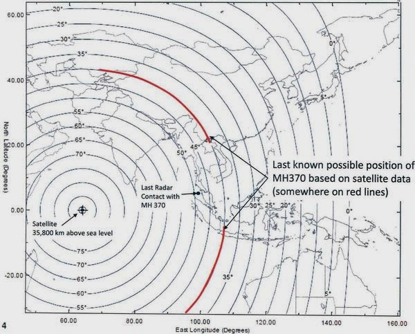
And if it travelled north, its path should be detectable on Myanmar radar (or Indian radar). So one takes one's chances on whose radar indeed did not detect the plane.If the plane did travel south, its path should be detectable on stored Indonesian military radar returns.
Re: Malaysian Airlines Flight MH-370 goes missing
The benign expalanation is the pilots set off to the deep indian ocean to ward of casualties on the land mass.
So what was the plane carrying?
So what was the plane carrying?
Re: Malaysian Airlines Flight MH-370 goes missing
Biological or nuclear device.
Re: Malaysian Airlines Flight MH-370 goes missing
^^^Ha, everyone is saying "Doppler effect", if it was ping round trip time it is more plausible.
One point of confidence in the INMARSAT model - they apparently performed calculations on the pings from known flights on known tracks.
http://www.businessinsider.com/how-sate ... ane-2014-3
One point of confidence in the INMARSAT model - they apparently performed calculations on the pings from known flights on known tracks.
http://www.businessinsider.com/how-sate ... ane-2014-3
Meanwhile, Inmarsat's engineers carried out further analysis of the pings and came up with a much more detailed Doppler effect model for the northern and southern paths. By comparing these models with the movement of other aircraft on similar routes, they were able to establish an "extraordinary matching" between Inmarsat's predicted path to the south and the readings that it got from other planes.
"By yesterday they were able to definitively say that the plane had undoubtedly taken the southern route," said McLaughlin.
Read more: http://www.businessinsider.com/how-sate ... z2wuIf2jVS
Re: Malaysian Airlines Flight MH-370 goes missing
Unless they identify confirmed debris from MH370 and trace DFDR and CVR, these confirmations would not be of any help.
Re: Malaysian Airlines Flight MH-370 goes missing
http://www.bbc.com/news/uk-26720772
andInmarsat senior vice-president Chris McLaughlin said the firm had studied electronic "pings" - or bursts of data - which the plane had sent to one of its satellites.
He told the BBC: "We have been dealing with a totally new area. We've been trying to help an investigation based on a single signal once an hour from an aircraft that didn't include any GPS data, any time and distance information.
"So this really was a bit of a shot in the dark and it's to the credit of our scientific team that they came up and managed to model this."
Mr McLaughlin continued: "They managed to find a way in which to say just a single ping can be used to say the plane was both powered up and travelling, and then by a process of elimination - comparing it to other known flights - establish that it went south."
Engineers spent all weekend looking back at a previous Malaysian Airlines Boeing 777 flights, going back several weeks.
They compared the satellite data from those flights with flight MH370 and were able to work out it went south.
This is cutting-edge modelling, never tried before. It uses the Doppler effect - which is what makes a police siren sound different from different points.
They had it reviewed by other scientists before handing it over.
As far as they can tell, the plane was flying at cruising height, above 30,000ft. They found no evidence of fluctuating heights being reported.
This is it now - they cannot pinpoint the position any further. They handed this data over on Sunday morning.
Re: Malaysian Airlines Flight MH-370 goes missing
Indeed. In fact the plane is cutting across the concentric circles centered around satellite (and everything is projected on to a plane along the direction of the vector connecting satellite to earth's center which is the inward normal) then the red arcs are incorrect. The northern mirror image - estimating by eyeballing the globe - might even pass through central China of the eastern most parts of Tibet.A_Gupta wrote:And if it travelled north, its path should be detectable on Myanmar radar (or Indian radar). So one takes one's chances on whose radar indeed did not detect the plane.If the plane did travel south, its path should be detectable on stored Indonesian military radar returns.
Who knows? May be Chinese don't want to come out and say they have been pwned by the Uighirs and the Tibetan and a part of central china east of Tibet is radar nanga.
Re: Malaysian Airlines Flight MH-370 goes missing
My thoughts exactly. As I said in the previous post, the mirror image will go through central China. The red arcs are wrong.chaanakya wrote:Unless they identify confirmed debris from MH370 and trace DFDR and CVR, these confirmations would not be of any help.
Re: Malaysian Airlines Flight MH-370 goes missing
Through twitter, Richard Westcott of BBC confirms that INMARSAT told him "Doppler".
I suppose then that the satellite does record frequency shifts of the size of a part in a thousand.
I suppose then that the satellite does record frequency shifts of the size of a part in a thousand.
-
Harpal Bector
- BRFite
- Posts: 226
- Joined: 11 Aug 2016 06:14
Re: Malaysian Airlines Flight MH-370 goes missing
The doppler data should be sensitive to the angle of the flight path to the axis of the satellite, but I really hope they didn't just plot all the doppler shifts from all the ac in the air that day and bin the data into north bound and south bound and then claim that MH370s shift data falls into the south bound cluster.
Unfortunately that kind of JMP based statistical analyisis passes for research in a lot of private industry and quite frankly it is very poor quality work.
Unfortunately that kind of JMP based statistical analyisis passes for research in a lot of private industry and quite frankly it is very poor quality work.
Last edited by Harpal Bector on 25 Mar 2014 01:05, edited 1 time in total.
Re: Malaysian Airlines Flight MH-370 goes missing
From a lurker:
Think of the sat location as a pole. The path of the plane is drawn (red line) as a circular arc around this pole. The path of the plane is parallel to the latitude around the satellite. This is not a great circle from Differential Geometry (Clairaut's Theorem).
Bottomline the figure displayed is incorrect. There should be no time lag is the plane is moving along the circular path. Yet there is. So most likely diagram is notional.
Re: Malaysian Airlines Flight MH-370 goes missing
How a doppler shift (or a ping roundtrip delay) can tell you north or south is beyond me; unless flying north versus flying south produces a doppler-perceptible difference in ground-speed (because the ground speed is determined by the prevailing winds + the plane's air-speed. Question - does an autopilot try to keep a constant airspeed or a constant groundspeed (or neither????))
Re: Malaysian Airlines Flight MH-370 goes missing
A_Gupta's point is a good one. Also, China/Myanmar/Pakistan/(BD?) radars did not have any record should have been taken at face value by INMARSAT and others doing analysis. These - the above by A_Gupta and the lack of radar evidence - are two of several other symmetry breaking factors and are measurable?
-
Rajiv Lather
- BRFite
- Posts: 287
- Joined: 20 Sep 1999 11:31
- Location: Karnal, Haryana, India
Re: Malaysian Airlines Flight MH-370 goes missing
Let us assume that some military radar or satellite gave the general area of the crash; but don't want it to be known. But what was the plane doing there and why ? So many holes...A_Gupta wrote:How a doppler shift (or a ping roundtrip delay) can tell you north or south is beyond me; unless flying north versus flying south produces a doppler-perceptible difference in ground-speed (because the ground speed is determined by the prevailing winds + the plane's air-speed. Question - does an autopilot try to keep a constant airspeed or a constant groundspeed (or neither????))
-
UlanBatori
- BRF Oldie
- Posts: 14045
- Joined: 11 Aug 2016 06:14
Re: Malaysian Airlines Flight MH-370 goes missing
The red lines are simply the locii where the plane MIGHT have been based on time for ping - at the last ping. At least that is how they presented it. It is not the trajectory of the plane.
However, the Duniya is a globe, hain? The PakSat is stationed directly above the Equator. Therefore, flight at constant altitude away from the equator is by definition "away from the satellite. Even if it is along a circle centered around the point on the equator where the satellite is centered. Could have gone to Maldives and southwards from there, too. Or west. Or north to Pakistan. I guess if they know the timings of all the other pings they can arrive at a unique solution. Or can they? Not from what they have said so far. As for Doppler effect, I wonder if they have the frequency captured well enough for that. If they have a device to play back the ping precisely, and mix (heterodyne) that with a signal of the sending frequency, maybe they can. OK, that will give speed with respect to the satellite, but same info may be derivable from the timings of the pings. Maybe that gives 2 equations to solve for the direction as well.
However, the Duniya is a globe, hain? The PakSat is stationed directly above the Equator. Therefore, flight at constant altitude away from the equator is by definition "away from the satellite. Even if it is along a circle centered around the point on the equator where the satellite is centered. Could have gone to Maldives and southwards from there, too. Or west. Or north to Pakistan. I guess if they know the timings of all the other pings they can arrive at a unique solution. Or can they? Not from what they have said so far. As for Doppler effect, I wonder if they have the frequency captured well enough for that. If they have a device to play back the ping precisely, and mix (heterodyne) that with a signal of the sending frequency, maybe they can. OK, that will give speed with respect to the satellite, but same info may be derivable from the timings of the pings. Maybe that gives 2 equations to solve for the direction as well.
Re: Malaysian Airlines Flight MH-370 goes missing
Which is puzzling me - surely what the satellite records is not the analog radio signal, but rather the digital signal encoded in it? Only some feedback loop on the satellite that attempts to fine tune its receiver to operate at exactly the received frequency would have this frequency shift info, would that be recorded? Simply don't have enough fundas to decode this; I hope INMARSAT publishes a paper on how they did what they allegedly did.UlanBatori wrote:If they have a device to play back the ping precisely, and mix (heterodyne) that with a signal of the sending frequency, maybe they can.
Re: Malaysian Airlines Flight MH-370 goes missing
UB, AG, It looks more and more like bokwas to bring closure to this episode. Soon they will find some jetsam and claim its the MH-370.
What Doppler shift are they finding in a digital signal?
This is another variation of PRC's 20 satterites to look for plane.
What Doppler shift are they finding in a digital signal?
This is another variation of PRC's 20 satterites to look for plane.
-
UlanBatori
- BRF Oldie
- Posts: 14045
- Joined: 11 Aug 2016 06:14
Re: Malaysian Airlines Flight MH-370 goes missing
Doppler shift:
They know by nanoseconds whether that signal was compressed a little -- or expanded -- by whether the plane was moving closer or away from 64.5 degrees -- which is the latitude of the orbiting satellite."
Ramana, the ping may be a set of, say, 128 cycles of a signal at a given frequency. That may occur in, say, x microseconds, which is x-hajaar nanoseconds. The return is also 128 cycles, but may take y-hajaar nanoseconds, where y.ne.x. If they have a counter that counts the number of clock cycles elapsed since the return pulse started, until it ended, AND a coarser clock that counts microseconds from when the pulse went out, to when it started being received, they have data on distance - which means angle relative to the satellite-to-Equator line, and relative velocity. PAKMARSAT frequency may be around 5? 10? GHz? ( I have no idea what band it is S? X? and I don't know what those letters mean, either). If the ping is 10 milliseconds long, that is a very large number of cycles, so very good accuracy to calculate Doppler Shift and convert to speed. This is how laser Doppler (and ultrasonic Doppler) velocimeters work, also how Doppler radar works, I bet.
But why Pakistan? Not BD or India or Myanmar? Did the plane come that far west??
DG CT is very much alive.
They know by nanoseconds whether that signal was compressed a little -- or expanded -- by whether the plane was moving closer or away from 64.5 degrees -- which is the latitude
Ramana, the ping may be a set of, say, 128 cycles of a signal at a given frequency. That may occur in, say, x microseconds, which is x-hajaar nanoseconds. The return is also 128 cycles, but may take y-hajaar nanoseconds, where y.ne.x. If they have a counter that counts the number of clock cycles elapsed since the return pulse started, until it ended, AND a coarser clock that counts microseconds from when the pulse went out, to when it started being received, they have data on distance - which means angle relative to the satellite-to-Equator line, and relative velocity. PAKMARSAT frequency may be around 5? 10? GHz? ( I have no idea what band it is S? X? and I don't know what those letters mean, either). If the ping is 10 milliseconds long, that is a very large number of cycles, so very good accuracy to calculate Doppler Shift and convert to speed. This is how laser Doppler (and ultrasonic Doppler) velocimeters work, also how Doppler radar works, I bet.
But why Pakistan? Not BD or India or Myanmar? Did the plane come that far west??
DG CT is very much alive.
Last edited by UlanBatori on 25 Mar 2014 01:25, edited 1 time in total.
-
Harpal Bector
- BRFite
- Posts: 226
- Joined: 11 Aug 2016 06:14
Re: Malaysian Airlines Flight MH-370 goes missing
The doppler effect would give you velocity data and the acceleration could be computed from any velocity change. A SB ac would have the opposite sign of coriolis acceleration as a NB ac.
-
Harpal Bector
- BRFite
- Posts: 226
- Joined: 11 Aug 2016 06:14
Re: Malaysian Airlines Flight MH-370 goes missing
If the INMARSAT can do that kind of measurement with the proper error accounting then I doff my hat to the physicists there.
Re: Malaysian Airlines Flight MH-370 goes missing
The UK guy was saying this is never before attempted work and was peer reviewed by scientists.
Re: Malaysian Airlines Flight MH-370 goes missing
Frequency locking is achieved using PLL (Phase Locked Loop) synthesizers and can be quite accurate (but cannot exactly say the accuracy level that can be achieved - depends on the quartz crystal purity and cut etc. There are also other means I guess).A_Gupta wrote:Which is puzzling me - surely what the satellite records is not the analog radio signal, but rather the digital signal encoded in it? Only some feedback loop on the satellite that attempts to fine tune its receiver to operate at exactly the received frequency would have this frequency shift info, would that be recorded? Simply don't have enough fundas to decode this; I hope INMARSAT publishes a paper on how they did what they allegedly did.UlanBatori wrote:If they have a device to play back the ping precisely, and mix (heterodyne) that with a signal of the sending frequency, maybe they can.
Re: Malaysian Airlines Flight MH-370 goes missing
Suppose you know the speed of the plane exactly.UlanBatori wrote: Therefore, flight at constant altitude away from the equator is by definition "away from the satellite. Even if it is along a circle centered around the point on the equator where the satellite is centered. Could have gone to Maldives and southwards from there, too. Or west. Or north to Pakistan. I guess if they know the timings of all the other pings they can arrive at a unique solution. Or can they?
1. Take the last known position, at 2:15 AM, somewhere over the Strait of Malacca, near waypoint IGREX.
2. Take your compass, set it to how far the plane would fly till 3:11AM and draw a circle on the earth's surface (or 10 km up) with last known position as center.
3. The 3:11AM ping puts the plane on an arc C determined by the satellite. This arc cuts your circle drawn in step 2 at two points. The plane has to be at one of these two points.
Rinse and repeat. For 4:11AM, there could be upto four spots the plane could be. But if you're lucky, the two spots from one circle are very close to each other; and the two spots from the other circle are very close to each other, and you get two narrow pencils of trajectories.
4. Since you don't know the actual speed of the plane, these narrow pencils widen.
Re: Malaysian Airlines Flight MH-370 goes missing
Yes, but would anyone be recording the feedback signal to achieve the frequency lock? This is the kind of operational data I imagine would not be kept.matrimc wrote:Frequency locking is achieved using PLL (Phase Locked Loop) synthesizers and can be quite accurate (but cannot exactly say the accuracy level that can be achieved - depends on the quartz crystal purity and cut etc. There are also other means I guess).A_Gupta wrote: Which is puzzling me - surely what the satellite records is not the analog radio signal, but rather the digital signal encoded in it? Only some feedback loop on the satellite that attempts to fine tune its receiver to operate at exactly the received frequency would have this frequency shift info, would that be recorded? Simply don't have enough fundas to decode this; I hope INMARSAT publishes a paper on how they did what they allegedly did.
-
Theo_Fidel
Re: Malaysian Airlines Flight MH-370 goes missing
Isn't it telling that only one of the INMARSAT satellites picked up the plane.
Here is the Map of INMARSAT coverage for reference. Note the gap between AOR-E & POR.

Here is the Map of INMARSAT coverage for reference. Note the gap between AOR-E & POR.
Re: Malaysian Airlines Flight MH-370 goes missing
When did MA guys say that the plane is lost and let it known to INMARSAT and other intl agencies who have tracking? If that was withiin the hour and INMARSAT has the ability to turn on storing of raw data (analog data along with pulse width or phase - depending on PW or PP modulation is used) they might have turned it on for those 8 hours and beamed it back to base station(s). Lot of these small details would not be interesting to the public who are watching CNN. They want broad picture in simple terms and hence the incorrect but understandable red arcs etc.A_Gupta wrote:Yes, but would anyone be recording the feedback signal to achieve the frequency lock? This is the kind of operational data I imagine would not be kept.
Also the picture Theo posted why do the coverage areas look like rounded rectangles rather than ellipses or circles? I can't think of any continuous transformation projection of a sphere that would result in those shapes. These may have been simplified for general consumption. The only case I can think of is because earth is a little flat at the poles. But I have no idea whether the flatness is so pronounced that there is such a great amount of distortion (eyeball estimate of the relative distortion). May be the picture presented with some exaggeration of the distortion for general consumption? Would it kill them to be a little more physically correct? Of course the other possibility is that my geometry sense is completely screwed up.
Last edited by Vayutuvan on 25 Mar 2014 02:41, edited 1 time in total.
Re: Malaysian Airlines Flight MH-370 goes missing
Paying customer determine the coverage by the satellite
Holes in the coverage shows that there is no customers in that region
Holes in the coverage shows that there is no customers in that region
-
Theo_Fidel
Re: Malaysian Airlines Flight MH-370 goes missing
Matrimc,
IME Companies like INMARSAT don’t mess up stuff like this. Their commercial lives are on the line.
I suspect it may have something to do with the antenna and receiver design. You often see these odd cell coverage maps based on the Antennae .
IME Companies like INMARSAT don’t mess up stuff like this. Their commercial lives are on the line.
I suspect it may have something to do with the antenna and receiver design. You often see these odd cell coverage maps based on the Antennae .
-
member_28502
- BRFite
- Posts: 281
- Joined: 11 Aug 2016 06:14
Re: Malaysian Airlines Flight MH-370 goes missing
Earth is not spherical or elliptical but some what pear shaped...
secondly the (oscillo)scope may be tuned to such precision before ellipse become circle (Lissajous figure, SHM)
thirdly as any mechanical engineer would not like sharp figures (with edges) stress {in real life watching sharp figures}concentration no?
** Added later***
also looks like the satellite scan range is more skewed towards Antarctica (south) region than Arctic regions (in north)
Population activity more Antarctica relative to Arctic ?
Last edited by member_28502 on 25 Mar 2014 03:21, edited 1 time in total.
-
Harpal Bector
- BRFite
- Posts: 226
- Joined: 11 Aug 2016 06:14
Re: Malaysian Airlines Flight MH-370 goes missing
They should publish this in PRL or atleast put on the arxiv. Let ordinary folk see what was done.
If they do thatand it checks out then I am willing to believe that SB route is the most likely path of the ac.
The SB route would not necessarily imply "the flight ended over water", there is still the mystery of why there was no detection by either Indonesian radar or by Aus radar on Cocos Island. The Malaysians may be jumping the gun.