Re: Malaysian Airlines Flight MH-370 goes missing
Posted: 26 Mar 2014 17:30
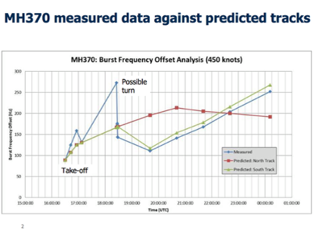
How is it so that they are spotting large field of debris , and not able to retrieve even a small piece of it, that could be linked incontrovertibly to MH370
Consortium of Indian Defence Websites
https://forums.bharat-rakshak.com/
what if it isn't official USA that is going to make use/misuse of this system. Then the hide-and-seek makes sense. Some culinary undercover stuff that doesn't take official USA into account.Harpal Bector wrote:If there was a sensitive cargo on it, the US could have simply asked the RMAF to bring the a/c down at a Malay airbase and recovered the cargo and had the jet go on its merry way.
The actual capabilities of today's spy sats are highly classified,but if Hubble can spot evidence of the Big Bang,billions of light years away,spotting large debris in the Indian Ocean is child's play for any decent spy sat.What is a keyhole satellite and what can it really spy on?
The code named Kennan "Keyhole-class" (KH) reconnaissance satellites have been orbiting the Earth for more than 30 years. They are typically used to take overhead photos for military missions. The big question for a lot of people is: "What can they see?"
A KH-12 is a $1 billion satellite that resembles the Hubble Space Telescope, except it is looking at our planet. For security reasons, there are no published orbit schedules for the imagery spacecraft. They are supplemented by the 15-ton Lacrosse-class radar-imaging satellites.
You can think of a KH satellite as a gigantic orbiting digital camera with an incredibly huge lens on it. Optical image reconnaissance satellites use a charge coupled device (CCD) to gather images that make up a digital photograph for transmission back to Earth from an altitude of about 200 miles. Since the satellites are in orbit, they cannot hover over a given area or provide real-time video of a single location.
The satellites are often placed into various secret orbits by NASA space shuttles or Titan 4 rockets and managed by the National Reconnaissance Office (NRO), headquartered in Chantilly, Va. Digital images from the satellites are analyzed, manipulated and combined by powerful computers at the National Geospatial-Intelligence Agency (NGA).
The black and white images are used by the military and civilian communities. Many of the details about this class of satellites remain classified, but it is known that there are several of these overhead at any given time. They have an imaging resolution of 5-6 inches, which means they can see something 5 inches or larger on the ground. These satellites probably can't read your house number, but they can tell whether there is a bike parked in your driveway.
Corona satellites, the first to do mapping of the Earth from space, had an imaging resolution of 6 feet. Those satellites were built by Lockheed Martin under contract to the CIA and the U.S. Air Force from 1960 to 1972 and were reportedly launched more than 100 times.
Mapping analysts can use satellite data to create 3-D images of land formations and structures on the ground. These images can then go to the negotiating table as countries try to end a war. Or, as in the case of the television show, the images can prove that the official word from a foreign government about some activity on the ground is not true. The same technology is also used to visualize potential escape routes for criminal activity. One was once reportedly used to observe the underbelly of an orbiting space shuttle for missing ceramic tiles, needed for re-entry.
In the United States, Vandenberg Air Force Base in California has been the primary site for the launch of many surveillance satellites during the Cold War and to the present. Some early satellites had capsules aboard to return film canisters to the Earth. The canisters were snatched in the air by Air Force crews over the Pacific Ocean. Since 1958 the special satellites were made by Lockheed Martin, and more recently Boeing has the contract with the National Reconnaissance Office.
Philip Ji,Philip wrote:Scamthony has allegedly vetoed any IN rescue/search efforts as he is sh*tting bricks that another mishap will consign him and his tattered political reputation to Davy Jones' Locker! he is already under alleged attack from within his own party fro his non-performance as DM,as well as dithering about election issues,taking no decisions in his own saintly country!
The PRC is making the maximum use of this crisis to send in the PLAN.The Chinese remember have the same word for "crisis " and "opportunity"! Carpe diem,they've "seized the day",while Scamthony has ,from falling off exposing his shockings,seized his dhoti!
Sent to me today by a "friend".Supposedly known to the Israelis.It provides the missing link,what I've always been asking,what was precious in the cargo?
The American is withdrawing from the Afghanistan, one of their command and control system (used for controlling the pilotless drones) was hijacked by the Talebans when the American transport convoy was moving down from one of the hill top bases. The Talebans ambushed the convoy and killed 2 American Seal personnel, seized the equipment/weapons, including the command and control system which weighed about 20 tons and packed into 6 crates. This happened about a month ago in Feb 2014.
What the Talebans want is money. They want to sell the system to the Russian or the Chinese. The Russian is too busy in Ukraine. The Chinese are hungry for the system's technology. Just imagine if the Chinese master the technology behind the command and control system, all the American drones will become useless. So the Chinese sent 8 top defense scientists to check the system and agreed to pay millions for it.
Sometime in early Mar 2014, the 8 scientists and the 6 crates made their way to Malaysia, thinking that it was the best covert way to avoid detection. The cargo was then kept in the Embassy under diplomatic protection. Meanwhile the American has engaged the assistance of Israeli intelligence, and together they are determined to intercept and recapture the cargo.
The Chinese calculated that it will be safe to transport it via civilian aircraft so as to avoid suspicion. After all the direct flight from KL to Beijing takes only 4 and half hours, and the American will not hijack or harm the civilian. So MH370 is the perfect carrier.
There are 5 American and Israeli agents onboard who are familiar with Boeing operation. The 2 "Iranians" with stolen passports could be among them.
.
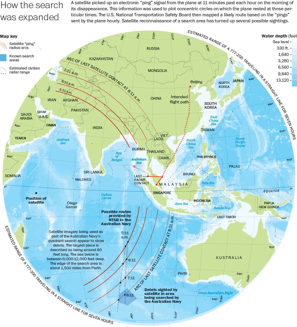
The plane flew over North Sumatra, Anambas, South India and then landed at Maldives (some villagers saw the aircraft landing), refuelled and continued its flight to Garcia Deigo, the American Air Base in the middle of Indian Ocean.
There are several spelling mistakes,etc. in the above quote,like the one about flying over S.India and the spelling of the Andamans,but it offers a plausible reason for hijacking the aircraft and taking it by stealth to a US mil base.DG,which is completely off limits and surveillance from the rest of the world.When lakhs of innocents have in recent years been killed by the US forces in the global hotspots,also using drones and brushed off contemptuously as "collateral damage",sending a few hundred passengers to their doom is child's play for it! We should not be surprised if such a heinous act was executed...with extreme prejudice.

Thanks, Lalmohan! By heading, I assume compass heading?Lalmohan wrote: 6. if you have gone from A to B and then disengaged FMS/AP and the aircraft is trimmed for straight and level and constant thrust (natural assumption) - it will continue to fly along this heading and speed unless acted upon by external forces (obviously as weight reduces with fuel burn the aircraft will go out of trim in the horizontal axis and changing winds will blow it along the lateral axis. over a 7 hour flight i find it hard to imagine that AP was not engaged atleast in the hold speed/height mode or direction mode (AP's have lots of different modes)
The ARGUS system can simultaneously view an area of 15 square miles from an altitude of 17,500 ft. While never losing track of the greater image, ARGUS can allow users to open up dozens of zoomable sub-windows and track individual vehicles and people anywhere in the city-wide field of view. It can spot objects as small as six-inches wide.
"There's actually enough resolution to be able to see the people waving their arms or walking around; what kind of clothes they are wearing," said Antonaides, pointing out a bird flying in the air several miles below the camera.
The system is capable of streaming a million terabytes of HD video every day, which is the equivalent of 5,000 hours of high definition footage. This immense trove of data is capable of being stored in perpetuity, so that the government can "rewind" the video and view things that have gone on under the drone days or weeks earlier.
"If we had our choice, we would like ARGUS to be over the same area, 24 hours per day, 7 days a week," said Antonaides.
A lot of airlines provide in flight internet access, usually through satellite uplinks. I'm not sure what the bandwidth or speeds are, but what you're suggesting should be possible using the data connection to stream video to an on ground supervision team.krishnan wrote:can you setup a CCTV inside each airline and have to monitored on ground ???
dont need to be ground team, it can be uploaded to any website , secured to be accessed by concerned personraj.devan wrote:A lot of airlines provide in flight internet access, usually through satellite uplinks. I'm not sure what the bandwidth or speeds are, but what you're suggesting should be possible using the data connection to stream video to an on ground supervision team.krishnan wrote:can you setup a CCTV inside each airline and have to monitored on ground ???
Great great great. We read stuff like this and then the fanboys start rahrahing - simply because one huge fact is left out. When you have great resolution you also have a huge amount of data. Those of us who have been searching through sat photo for debris on Tomnod.com will realise that you can view ten thousand 20 meter resolution images of the ocean and spot exactly nothing. Unless you know where to look for what you want to find - great resolution is a fine talking point but is of little practical use. Ultimately its the low res pictures that create suspicious areas that need to be looked at with greater and greater detail - and this is labour and time intensive.Philip wrote:The ARGUS system can simultaneously view an area of 15 square miles from an altitude of 17,500 ft. While never losing track of the greater image, ARGUS can allow users to open up dozens of zoomable sub-windows and track individual vehicles and people anywhere in the city-wide field of view. It can spot objects as small as six-inches wide.
"There's actually enough resolution to be able to see the people waving their arms or walking around; what kind of clothes they are wearing," said Antonaides, pointing out a bird flying in the air several miles below the camera.
The system is capable of streaming a million terabytes of HD video every day, which is the equivalent of 5,000 hours of high definition footage. This immense trove of data is capable of being stored in perpetuity, so that the government can "rewind" the video and view things that have gone on under the drone days or weeks earlier.
"If we had our choice, we would like ARGUS to be over the same area, 24 hours per day, 7 days a week," said Antonaides.
Yes, but you would think that computerization should be available. Especially on the ocean, where most of it is ocean and clouds. For land, I'll admit the number of possible features may be too large. Surely software can eliminate 90% of the useless stuff on the ocean and present "features" to human eyes to classify.shiv wrote:Those of us who have been searching through sat photo for debris on Tomnod.com will realise that you can view ten thousand 20 meter resolution images of the ocean and spot exactly nothing. Unless you know where to look for what you want to find - great resolution is a fine talking point but is of little practical use. Ultimately its the low res pictures that create suspicious areas that need to be looked at with greater and greater detail - and this is labour and time intensive.
http://edition.cnn.com/2014/03/25/opini ... index.htmlwhat was on board Flight 370? Malaysian officials, after saying the cargo manifest would "be released in due course," later got a little more specific and said the Boeing 777 was carrying 440 pounds of lithium ion batteries. What else? Nothing that would cause a problem, the Malaysians assure us. An Australian news media report said the Malaysian government refused to release the manifest to the Australian government, which would find such information helpful as it tries to map out a search.
In ArizonaLalmohan wrote:sensitive cargo is flown out
drone station is at bagram i think
all busy in afpak and unkil keeping his powder dry in europe?Singha wrote:and the global hawk has been resounding in its absense from the scene.
with a 30 hr endurance it ought to have flown out and do the searching than Orions with 2 hrs time over target.
and it has far better rated IMINT sensors than orions whose main focus is ASW
afaik the long range one is outside las vegas in nevadaNijalingappa wrote:In ArizonaLalmohan wrote:sensitive cargo is flown out
drone station is at bagram i think
Gupta saheb please see this Operation Manual for training Delta Airlines Pilot for Boeing 777-200ER. I think this will give you the idea of various control switches on FMS particularly Auto Pilot and Flight Director component.Instrument panels are numbers and described excellently.Cockpit is in display.A_Gupta wrote:Questions about autopilot & flight management computer --- thanks in advance for any pointers.
We've seen already that the above can be programmed to take one from waypoint to waypoint.
Is it correct that the path taken between waypoints is a great circle?
Suppose you have set the flight control computers + autopilot to take the plane from waypoint A to waypoint B, but you do nothing further when the plane reaches waypoint B. What is the likely behavior? The plane continues on the same great circle? Or does the plane continue keeping the compass heading constant?
When autopilot is engaged, does it try to keep a constant ground speed? Or a constant air speed?
Thanks!
http://www.cbsnews.com/news/malaysia-ai ... s-improve/"We investigated a couple of visual contacts that actually just turned out to be marine mammal activity. So unfortunately didn't find anything further to report today," said Flying Officer Peter Moore.
. Flight Director Switch
ON: Displays the flight director command bars on the associated ADI
Turn on the F/D switch on the ground with no autopilots engaged. If no autopilot is engaged, the flight director defaults to heading hold and vertical speed mode.
OFF: Turns off the flight director display bars on the ADI
Thanks!chaanakya wrote:
Gupta saheb please see this Operation Manual for training Delta Airlines Pilot for Boeing 777-200ER. I think this will give you the idea of various control switches on FMS particularly Auto Pilot and Flight Director component.Instrument panels are numbers and described excellently.Cockpit is in display.
Below is rather long tutorial right from takeoff to landing of Boeing 777-200ER and it would give idea about how routes are set up in FMS besides other actions taken by pilot for smooth flying. ......
This is from May 2012, dunno how fast the Aussies move.Harpal Bector wrote:Is there no military radar on the Cocos Keeling Islands currently?