Re: India & Natural Disaster Management
Posted: 02 Jul 2013 16:14
how ??? are you going to demo the structures that have come up there , trees would have been pulled down to make way for buildings , you cant demo all of them
Consortium of Indian Defence Websites
https://forums.bharat-rakshak.com/
Climate Himalya teaches more on disaster management in himalaya.Receding Glaciers: One of the scientific studies of 1,317 glaciers by Indian defense research organization in 10 sub-basins since 1962 of Indian Himalayan region finds 16% glaciers shrank during last 50 years. This study finds that in 100 years period there is 1.6°c rise in temperature, the precipitation rate has increased and rate of snowfall decreased, leading to reduced river discharge.
The 2008 National Action Plan on Climate Change explicitly states that two-thirds of forest cover in Himalayan regions must be maintained, advice ActionAid’s Sehjo Singh says was ignored by local authorities.
“The large scale deforestation and massive construction projects, especially large dams and hydro-power projects, have weakened the ecosystem of the region and the accompanying effects of climate change is further galvanizing the destruction.”
The increasing pace of human intervention and deforestation in the Himalayas is potentially devastating. It could lead to the gradual choking off of the life support systems of local inhabitants and of the many millions in the Ganges Plain below, who depend on the forest for the proper regulation of water flow and the containment of flash flooding. Our local partner is CHIRAG, a small but outstanding indigenous development organisation. We ourselves focus on the forestry aspect of the programme albeit CHIRAG is also involved in community health, education, agriculture and income generation initiatives.
http://www.thebrt.org/project_india.htmlSince 1997 we have funded the reforestation of around 4,000 acres (1600 hectares) of degraded hillside together with providing adult training and environmental programmes in schools. Success has depended on motivating and inculcating new skills and attitudes amongst the villagers, especially the women who are the main user group. Villagers participate in all aspects of forest development – from initial project planning through to planting out the trees and their ongoing management. All tree seedlings are produced in small home nurseries to supply the 120,000 we need for outplanting each year.
Biogas from cow dung {can this be applied to Ponies' Dung?}
Cooking with biogas (click the link below for pictures)
All benefits from the forest, such as wood collection and grass cutting, are kept within the community and any payments are made to locals rather than to outside contractors. Biogas technology, which creates gas for cooking from cow dung, has been introduced to provide an alternative to wood fuel and so reduce pressure on the forest.
Hydrology and watershed protection
The entire project is located in the Mid-Himalayan watershed area. The rate of soil erosion from these
steep slopes is estimated to be 50 t/ha of soil annually. Thus, soil erosion will be reduced by 70-80 %
with A/R activities. A number of streams and rivers originate in the area and feed major northern Indian
rivers. These streams and springs are likely to increase their discharge rate with the intervention under
the A/R activities. While in a short span of time it may not show these positive impacts, but in long run,
A/R activities will help in source sustainability of these springs and streams.
A/R activity would enable protection and improvement of soil on these lands and facilitate rainwater
percolation. Tree cover increases soil moisture. Hence, it would enhance the productivity of these lands
along with recharging of ground water.
Reduction of vulnerability of mountain forest ecosystem
According to the reports of IPCC (Working Group II) the forest ecosystems and the hilly mountainous
ecosystems are highly vulnerable to climate change. A study (Ravindranath et al. 2006) on impact of
climate change and forest ecosystems in India has shown that most the forested grids of Himachal
Pradesh are highly vulnerable to climate change and are projected to experience change in forest types,
before the end of the current century.
A/R activity which includes planting of multiple species would reduce the vulnerability since different
species have different temperature tolerance. Thus, the mountain forest ecosystems including degraded
forests will be less vulnerable to impacts of climate change.
Reduced flooding
Lower elevation areas of Himachal Pradesh and neighboring states of Punjab, Haryana
experience floods during monsoon from rivers flowing from higher regions of Himachal Pradesh.
CDM plantations in the hilly catchment of rivers such as Ravi and Beas and their tributaries will enhance the harvest and percolation of rainwater in the plantation area. This will reduce the surface runoff of rainwater that normally causes floods.
Demonstration effect of watershed protection and carbon revenue incentives
Large-scale implementation A/R CDM project activities, covering 4003.07 ha and the flow of
CER revenues and other benefits such as increased grass and fuelwood supply, enhanced NTFP
availability will have a demonstration effect on the neighboring villages and GPs.
The neighboring GPs and farmers may also wish to undertake reforestation activities for the
protection of watershed as well as creation of carbon sinks.
Reduce landslides
Occurrence of landslides is a common phenomenon in the hilly regions of Himachal Pradesh
during the rainy season. The state has about 2.4 million hectare of wasteland without any
vegetation cover. Furthermore, about 0.53 million hectare are open forests. These lands are
vulnerable to landslides.
CDM A/R plantations on degraded land will stabilise these lands and help to reduce their
susceptibility to landslides, outside the project boundary.
http://www.fao.org/docrep/ARTICLE/WFC/XII/0082-B1.HTMThis R & D effort provides an inspiring model for reforestation of degraded lands and biodiversity conservation and needs replication not only in the Himalayas/mountains but also in the other parts of the world where sacred sites and pilgrimages are important and the environment has been severely threatened.
Theo_Fidel wrote:It is sad to say this but not a single person noticed previously that the lake level is a good 50'-60' below the outflow lip. Meaning we have a lake with no controlled outflow. Despite what it looks like the failure was unlikely to be caused by overtopping. Overtopping rarely causes catastrophic failure as was seen here. The presence of a lake far below its outflow level immediately tells me the hydraulic seepage is ongoing in the morraine dam. Moraine structure is extremely porous and folks would be surprised to know that random pile of rocks is often 20%-30% open space. During normal time, when water is low the structure is quite stable but when you add water pressure things change in jiffy. The pressure of water acting at the base of the structure will cause hydraulic piping. Hydraulic piping will fill the interior of the dam with water. The pressure of this water will then lift the rocks up, yes water pressure is this strong, and this failure of gravitational stability will cause the entire dam to slide down stream under the push of water. The failure occurs at the base. The worst dam disasters are caused by this. This is the reason why all dams, even massive ones like Nagarjuna Sagar have drainage galleries deep within the dam. As long as the water that seeps into the dam is drained everything will be stable. In the absence of interanl drainage this structure was quite simply a bomb waiting to go off.
I suspect a single 12" steel pipe driven into the base of this structure would have prevented its catastrophic failure. Overtopping sure but that would have been a slow hours long event. There must have been hundreds of geologists and hydraulic experts, thousands of the many dam engineers working in that area who visited this structure and yet no one put 2+2 together for this particular lake.
Singha saar,
I looked at the lakes above Badrinath that you pointed out. If you are talking about Lake Deo Tal types, it is not not similar, they conspicuously drain over their lip. Sure they can fail in an overtopping but in that case the smaller quantity inside this lake will be the least of your problems! Also some of those lakes appear to drain over the pass into the Sutlej Basin and lack a conspicous drain area to cause failure. Yes there are a few other smaller lakes that could bear watching. And there appear to be many of these moraine wall structures that could similarly fail. Landslides are concern as you pointed out, but it is hard to avoid that danger in these areas. My concern also would be a glacial lake outburst. Several of the glaciers reach all the way down to river bed. A rapid movement or ice/snow avalanche could easily cause a lake forming event, that would then fail in catastrophic outburst in a matter of hours or days with no one the wiser. Takes constant monitoring, on a daily basis with sensors.
OTOH there are several moraine lakes in the area that look precarious.
Here is one in the Dhauliganga River, where the Dauliganga dam is located down stream. The yellow line is 500 m +/-, so quite large.
While the state's juggernaut finally rumbled to life and responded to nature's frothing revenge of its wanton destruction along the flood-plains of the Mandakini - a revenge that flattened the surreal township built around the ancient temple of Kedarnath - merely rescuing pilgrims and rural communities wedged along the craggy Himalayas must not occasion selfcongratulation .
After the fall, figures resound imposingly: thousands of sorties by air force helicopters, more than a lakh people evacuated, one of the most gigantic 'rescue' missions ever embarked on anywhere in the world, etc. The majesty of the state, for some moments, seemed to equal the majesty of the mountains from where sprang the cold fury of a cloudburst and a trapped lake.
The word 'rescue' is a bit of a misnomer, here. It is essential for preventing a repeat of the colossal tragedy that struck Uttarakhand that we make a distinction between 'rescue' and 'evacuation' . To rescue is to save or liberate. And what needs to be rescued or saved are the Himalayas, if the people living by it are to be redeemed from the terrible consequences of the now increasingly regular landfalls and cloudbursts.
Over the last 15 years, the frequency of such heavy, concentrated rainfall has increased. Ukhimath saw this in 1998, followed by a series of such events in 2002 in Phata in Mandakini valley, Khedgaon in Kumaon, and Agunda in Bhilangar valley. In 2003, Tehri too saw such abnormally high rainfall, as did Ladakh in 2010, which triggered massive mudslides leading to 255 deaths and damage running into hundreds of crores of rupees.
Experts say Kedarnath is on the paleo-channel or the ancient floodplain of the Mandakini. Settlements on such plains increase human vulnerability to a natural phenomenon like flooding. The real reason behind the catastrophe , they say, was overloading of the hill slopes with built structures . But while we all know this, is that all? Not by a long chalk.
Until a few decades ago, a visit to Kedarnath was considered hazardous enough for people to begin their pilgrimage early in the morning and return late afternoon. Overnight stay at the shrine was not advised because of turbulence along the Kedarnath peak and Kedarnath dome that tower over the valley. Its unpredictable weather has been logged by a number of intrepid travellers who have trekked to Kedar dome.
While a skewed development model - in favour of man's shortterm ends, never mind the longterm damage to the Himalayas - is being repeatedly underlined as the reason behind the great tragedy, activists and nature lovers observing the mountains over the last several decades have pointed out to more "organic" reasons for the decay.
A drive to Uttarakhand just a few weeks before the flashfloods was revealing: these parts of the Himalayas that once boasted of oak forests had turned into pine woods. Now, oak is an un-exploitable tree for commerce compared to the pine that has a variety of uses. From pine resin to its wood, everything is used profitably by man. Garhwal Mandal Vikas Nigam will soon show off its marvellous pine cottages in Lansdowne for all to gape at.
However, in a paradox that must not surprise, what's profitable for man is not profitable for the Himalayas. In fact, it is deleterious and seriously so. The oak is a wonderful tree that in fall over years and decades creates a layer of black subsoil that nourishes the thickest undergrowth one can ever see. These scrubs and brushwood feed on rainwater that seeps down to create an organic whole, a sort of natural masonry that toughens and fortifies the soil against erosion caused even by heavy rainfall.
Some of the most severe damage in last month's flood was caused by giant logs of fallen trees - up to 20 feet long and three feet in diameter - washing down the river waters and knocking down homes, hearths and bridges alike. It was the preponderance of pine and absence of oaks that caused this cataclysmic destruction of human settlements. Pine trees, unlike the oak, do not grow leaves, but needles that fall and form a smooth dry bed that does not soak water. This prevents the soil from developing underbrush.
If one lifts a carpet of pine needles one will see bare mud on the ground and nothing else - much like the topsoil of Ladakh. This is one of the causes of the fragility of the Himalayas in Uttarakhand as has been pointed out by a number of activists, including Gandhian Mira Behn in the 1950s. If one looks at the mountainsides in Joshimath, they appear almost flaky. You feel you could scratch a layer off with your nails.
Oaks are not protected by law enforcers. In any case the forest department, comprising no doubt some prized ignoramuses, do not mind this because they watch the pines creep up where once were oaks. "Green cover" is all that they need to show, the type of green be damned. And if the pine spins out more money, where is the harm? As Uttarakhand showed last month, it's just a cloudburst away.
We may have little or no control over very heavy rainfall and cloudbursts. But we can mitigate the devastation of the Himalayas by foresting it with trees that can hold the mountains together: the trusty old oak. It will take decades, and perhaps earn governments less revenue. But there is a price also to be paid for the destruction so far.
Piyush Rautela, executive director at the state's Disaster Mitigation and Management Centre (DMMC) told TOI from Dehradun that the alert had been issued for the areas in Badrinath, Mana and Pandukeshwar.
The threat came to light after Isro's Hyderabad's National Remote Sensing Centre (NRSC), following a request from the state government, processed satellite pictures of the area and alerted Dehradun to the threat.
According to images released by NRSC, the landslide and subsequent lake formation occurred in the aftermath of the June 15-17 rains that led to unprecedented devastation in the state. The bulge in the river just downstream of Alaknanda's source — the Bhagirath Kharak and Satopanth glaciers — is visible in an IRS image taken on June 21. The feature persists in a RISAT-1 picture taken on July 7. The spot is around 8km from Badrinath.
NRSC director V K Dadhwal told TOI that, according to the images, the situation was not threatening. "The amount of water accumulated does not appear to be very high," he said.


Bade wrote:http://timesofindia.indiatimes.com/indi ... 735302.cmsNatural calamities are common in Uttarakhand, which lies in the fragile mountain belt of the Himalayas and has experienced tectonic turmoil several times in the past. Since the last quarter of 20th century, there has been an increase in the frequency of natural disasters in this region. Major disasters in the recent past include earthquakes of 1991 and 1999 in Uttarkashi and Chamoli respectively, landslides at Okhimath and Malpa in 1998 and cloudbursts and flash floods at Khetgaon and Budakedar during monsoon in 2002.
Aniruddha Uniyal, a senior geo-scientist at UP Remote Sensing Application Centre, Lucknow, says the disasters are getting frequent due to sudden increase in anthropogenic activities like unplanned cutting of slope, blasting of highly jointed rock mass for road construction and unplanned disposal of the slope cut debris. All these have further added to the fragility of the Himalayan mountains and made this region vulnerable to natural disasters.
The argument is also marshaled in support of their contention by most of environment activists like Medha Patkar, who see natural calamities as man-made in Uttarakhand. They stress the need for development with concern for environment. On the contrary, the need for the development of the region stems from the fact that its sizeable part borders China and thus leaving it undeveloped will be a security risk.
Three districts -- Uttarkashi, Chamoli and Pithoragarh fall on the McMahon line, which demarcates India and China. The underdevelopment of the region cost India heavy when the army found it difficult to fight against the advancing army of the China in 1962 war in the area. Thus it was then when these districts were conferred a status of border districts by the then prime minister Jawaharlal Nehru.
The bottom line of the debate is thus the prevailing situation in Uttarakhand calls for a shift in approach. While the concern for environment is the need of the hour, it simply cannot ignore the need for development, which has to be kept in pace with the ever changing needs of the region and a growing aspiring population. Maoists, too, are gaining ground at some places in the hills, especially in the border districts, by highlighting the "underdevelopment of the region".
So there is a need to go in for development model, which is area-specific and not based on a borrowed theme. Thus the lesson comes from these incidents is to have development in harmony with nature, restriction on the overflow of the tourists, emphasis on disaster management with facilities for facilities of helipads at well-identified strategic locations and afforestation which could meet the need of fuel, fodder and timber rather than just going for pine tree, which was promoted by the British to flourish the resin industry.
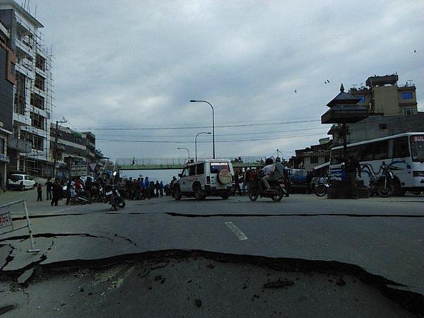
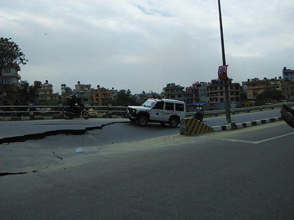
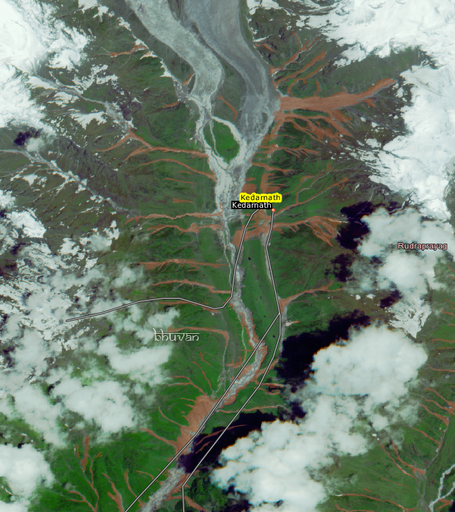
-The island-like patch of green, north of Kedarnath, has a new, white-colored channel carved through it....result of the recent flood. I am not sure how that channel formed, because the green patch is really a small hill/hillock. Either water flowed uphill (which it does not) or the water level upstream was higher than the hill at that point.!!Bade wrote:Bhuvan has some updated imagery showing landslide areas overlaid.
Rob Williams
Friday 20 September 2013
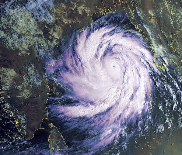
A monster Super Typhoon has intensified explosively in the the last 24 hours and remains on track to wreak havoc in Taiwan, the Phillipines and potentially Hong Kong over the weekend.
Over the last day Super Typhoon Usagi, which is now the strongest storm to form on earth this year, has seen winds increase from 75 mph Tuesday to over 160 mph. The cyclone is now classified now as a Super Typhoon and is considered the equivalent of a category 5 hurricane.
The storm, which is expected to maintain its current strength for at least the next 24 hours, is on course to dump 1000mm of rain (three times the annual London rainfall) on Taiwan over the next three days.
The storm is set to roar between the Philippines and Taiwan before hammering the southern Chinese coast, and possibly Hong Kong, later in the weekend.
Experts have said that due to the lack of 'hurricane hunter' aircraft in the Pacific they can't accurately measure how strong the storm is, and that it maybe even stronger.
According to Quartz one satellite-based estimate ranks the storm as the most powerful on the planet since 1984, having a minimum central pressure of 882 millibars.
Typhoon Usagi will first batter coastal Taiwan bringing with it damaging winds, a significant storm surge and heavy and persistent rain, before heading towards Hong Kong. Peak winds are at that time predicted to have weakened to around 100mph.
Usagi is a very large tropical typhoon with a diameter of 1,100 kilometers (680 miles). Its outer rain bands were extending across the main northern Philippine island of Luzon and southern Taiwan and strong winds outward up to 220 kilometers (135 miles).
It is packing the 24-hour rainfall accumulation of 500 millimeters (nearly 20 inches) near the center of the typhoon.
Philippine weather bureau forecaster Alvin Pura said that the typhoon had gathered strength and speed with gusts of 240 kph (150 mph).
The Batanes Islands, population 16,000, were placed under the highest storm alert, while lower warnings were raised in at least 15 northern provinces where officials warned of flash floods, landslides and storm surges.

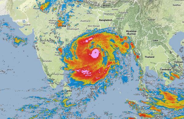
This cyclone will test preparedness of NDRF and District authorities. Cat-5 storm is one of the strongest witnessed in recent memory in India. Eastern Coast is always vulnerable to Cyclones but level of preparedness is not always up to mark.NEW DELHI: The weather office may be underestimating the severity of a cyclone which is hurtling towards the east coast, a meteorologist warned on Friday, adding that it could be worse than Hurricane Katrina which devastated parts of the United States in 2005.
Cyclone Phailin is forecast to hit the coast between Kalingapatnam in Andhra Pradesh and Paradip in Odisha late on Saturday with a maximum wind speed of 220kmph (135mph), the India Meteorological Department (IMD) said in its latest bulletin.
However, both London-based Tropical Storm and the US navy's Joint Typhoon Warning Centre forecast winds reaching 315kmph (195mph) on landfall, classifying Phailin as a Category 5 storm — the most powerful .
"Phailin is already worse than what the IMD is forecasting. A recent satellite estimate put Phailin's current intensity on par with 2005's Hurricane Katrina in the United States," said Eric Holthaus, meteorologist for Quartz, a US-based online magazine which covers global economy-related issues.
"Everything I know as a meteorologist tells me this is the equivalent of a Category 5 hurricane — among the strongest on earth in 2013. That would mean Phailin could be the strongest cyclone ever measured in the Indian Ocean."
Hurricane Katrina hit the US Gulf coast on August 29, 2005, killing more than 1,800 people, driving 2.16 million from their homes and causing $75 billion of damage.
Cyclones in the Bay of Bengal are common at this time of year, often causing deaths, mass evacuations of coastal villages, power and telecoms disruptions and widespread damage to crops and property in eastern India and Bangladesh.
Some experts have compared Phailin with a super cyclone in 1999 that killed 10,000 people when it battered the coast of Odisha with wind speeds reaching 300kmph (185mph).
Weather authorities were reluctant to make comparisons with Katrina and the 1999 cyclone, dismissing reports that Phailin is half the size of India.
"It is very difficult to compare two cyclones and their possible impacts. They are different entities and their crossing point along the coast matters a lot. At the same time, there is a resemblance in terms of intensity, so there is some similarity with the 1999 cyclone," IMD director general LS Rathore told a news conference.
The cyclone is pretty voluminous, but it's not half the size of the country and its radius keeps increasing and decreasing."
Holthaus said he was not familiar with India's level of disaster preparedness but was concerned that any underestimation of the storm's intensity could put lives at risk.
"I feel that IMD's underestimate of the strength and impact of this storm is potentially tragic and could catch many millions of people off guard," he said. "Anything short of a full-scale motivation may leave people stranded in flood waters. The highest possible precautions should be taken immediately."
The cyclone could disrupt the lives of millions, the Global Disaster Alert and Coordination System (GDACS) run by the United Nations and the European Commission said.
"Up to 6.1 million people can be affected by wind speeds of cyclone strength or above. In addition, 47,000 people are living in coastal areas below 5 metres above sea level and can be affected by storm surge," the GDACS website said.
Authorities began moving thousands of people living along Odisha's coastline to shelters early on Friday, as weather officials warned of extensive damage to homes, power and telecoms disruptions and flooding.
The local government cancelled workers' holidays during the popular Hindu festival of Dussehra to help prepare for the storm, and the Army, Navy and Air Force have been put on standby for rescue and relief operations.
Rations are being pre-positioned in cyclone shelters, schools and other buildings on higher ground, control rooms set up and fishing suspended.
Aid workers said the authorities' level of disaster preparedness and early warnings looked satisfactory.
"There has been a phenomenal change in disaster management in Odisha since the super cyclone in 1999. The action the leadership has taken is exactly what is needed," said Unni Krishnan, head of disaster response for Plan International.
CAT-2 is what it will be after moving inland land -per predictions. CAT-5 it is already.TSJones wrote:CAT-5 That's just.......huge. I've been through a CAT-2 and it was awful enough. I didn't dare go outside the house for fear of getting struck by flying debris. It will make you very religious. Best wishes.


Apart from the defense forces, there is a need for states to step up and invest in their civil organization for aid and relief, especially some states where certain types of disasters are highly likely. There seems to be an over reliance on the center and on armed forces.The Uttarakhand disaster highlighted the incorrect handling by NDMA and corresponding state agencies. The negligible response mechanism added to the woes of the people. Lack of accountability seems to be a major contributing factor in the present structure. Not a single person was dismissed or strictures passed for poor response. It is prudent that there is a rethink on the role of NDMA and the state structures. There is an overwhelming need for amalgamation of the armed forces in disaster management structures at the apex level for an organized, quick and efficient response mechanism.
Already NaMo said Nepal would also be helped as per India TV news. Eight NDRF teams are sent to Districts under threat. Evacuation has been ordered. CMC met today and CabSec has assured all help to Bihar CS and no politicking on this. Specialists Team has been sent to nepal to help them.A landslide in Nepal has led to creation of an artificial dam on river Kosi, triggering possibility of a flood that could affect parts of Bihar,
government said here on Saturday as it swung into action to control any possible damage.
The Crisis Management Committee (CMC), headed by Cabinet Secretary Ajit Seth, held an emergency meeting here in view of the development and a decision was taken to rush some experts to Nepal besides 15 teams of National Disaster Response Force (NDRF) to Bihar.
When contacted, Seth said that Prime Minister Narendra Modi has directed all help should be rendered to Bihar as well as Nepal to meet any eventuality.
Significantly, the development has occurred a day ahead of Modi’s two-day visit to Nepal. Officials said the Prime Minister was concerned over the situation and spoke to Seth to do all the needful.
The Cabinet Secretary spoke to Bihar Chief Secretary and promised all assistance from the Centre. A team of experts has been rushed to Nepal to help them with technical support, the officials said, adding if need be more experts could be sent.
Eight teams of NDRF have been sent to Bihar from Delhi and seven from Kolkata to help in rescue and relief. The priority is evacuation of people and animals from the areas that could bear the brunt of the floods.
Due to the landslide, about 20-27 lakh cusecs of water has got collected in the artificial dam, the officials said. Nepalese authorities are making “controlled breaches” in it so that water can be released slowly and in less quantity.
However, if these efforts do not succeed and the artificial dam bursts, parts of Bihar could face “temporary floods” within 14-18 hours, the officials said.
Places like Madhepura, Supaul and Saharsa could face the maximum damage if floods occur, the officials said, adding places like Madhubani and Khagaria could also have some impact. About six years back, floods due to breach in Kosi river had led to massive devastation in Bihar.