And it is another mod who had that rank
Indian Space Program Discussion
Re: Indian Space Program Discussion
No, I was wondering what the hell the congressmen was talking about
And it is another mod who had that rank
And it is another mod who had that rank
Re: Indian Space Program Discussion
No, not the B-52 based UCAV that patrols Bajaur, but my fav character from Arthur Conan Doyle (swagger at its best) and that was the point 
-
putnanja
- BRF Oldie
- Posts: 4782
- Joined: 26 Mar 2002 12:31
- Location: searching for the next al-qaida #3
Re: Indian Space Program Discussion
India, US to do the moonwalk
About 400,000 km from planet earth, there are probably chunks of ice trapped inside huge craters on the moon’s surface. And they have been left untouched by the sun for about two billion years. This has so far been a conjecture.
Indian Space Research Organisation (ISRO) and National Aeronautics and Space Administration (NASA) of the US are going to find out whether those dark holes actually hold ice and the secret of the solar system.
...
The first such effort by the space faring nations will involve two lunar orbiters, Chandrayaan-I and Lunar Reconnaissance Orbiter (LRA) of NASA, operating in sync over the moon’s polar region. They will bounce radar signals off the craters to spot the nether world of ice.
...
Re: Indian Space Program Discussion
Reported first on BRF, before all these news wallahs....RaviBg wrote:India, US to do the moonwalk
About 400,000 km from planet earth, there are probably chunks of ice trapped inside huge craters on the moon’s surface. And they have been left untouched by the sun for about two billion years. This has so far been a conjecture.
Indian Space Research Organisation (ISRO) and National Aeronautics and Space Administration (NASA) of the US are going to find out whether those dark holes actually hold ice and the secret of the solar system.
...
The first such effort by the space faring nations will involve two lunar orbiters, Chandrayaan-I and Lunar Reconnaissance Orbiter (LRA) of NASA, operating in sync over the moon’s polar region. They will bounce radar signals off the craters to spot the nether world of ice.
...
All the reports do not do justice to the magnitude and significance of this experiment - it isn't just a search for volume ice. It is the worlds first space based Bistatic Radar!!!
Re: Indian Space Program Discussion
Why is the Indian Space Program thread in the MILITARY forum? ISRO is clearly separated out from the Indian Military/DRDO etc., and it is a CIVILIAN program. Putting this in the MILITARY forum is a shameless genuflection to those anti-India people who keep insist that the purpose of Indian space launchers, satellites is all to attack other nations. It is a disgrace that this is done on a site which claims to be about articulating the Indian point of view.
By the same token, the Indian Space Program is not a "STRATEGIC" one either. "Strategic Space" immediately conjures up images of ICBMS and STAR WARS type things, or about putting weapons on the Moon.
However it is not entirely an ECONOMICs /COMMERCIAL program either. The Indian space program is about advancing human knowledge, bringing education to people, bringing infrastructure such as communications, providing navigation support, and a very large and traditional strength is in Earth Resource Sensing, which is immensely valuable to such things as seeing where the River Saraswati flowed, where Shri Ram's Vanara Sena built the Sethu causeway, where the temples of Mahabalipuram and Dwaraka lie submerged. Remote sensing is also about seeing tectonic faults, glacier changes, crop yields and mineral deposits using ground-penetrating radar.
For these reasons, Space is obviously a General Discussion topic, and hence I propose to move it to the GD forum. If anyone has strong objections, I am going to be generous and reasonable unlike the people who arbitrarily jerk active threads around, and allow people to make coherent, clear, well-reasoned arguments why they want to continue this abomination of placing the Indian Space discussion in a MILITARY forum.
Jai Hind.
Re: Indian Space Program Discussion
All space programs have military applications. NASA and its contractors don't hide their military collaboration. Under Obama, NASA is supposed to increase cooperation with the military.
What was RISAT2? The TES? The soon to be launched IAF satellite? Aren't IAF men to be selected for the manned mission?
What was RISAT2? The TES? The soon to be launched IAF satellite? Aren't IAF men to be selected for the manned mission?
Re: Indian Space Program Discussion
For that matter, all FOOD has military applications. What do the (IAF) astronauts and (IAF) satellite developers and soldiers eat? So shouldn't the FOOD thread be in the MIL FORUM?
The excuse that "All space programs have military applications" is the classic western "Sanctions Regime", where all research involving the Laws of Physics are considered "DUAL USE" and all humans who can count are considered terrorists.
SHOCKING to see this reasoning advanced on BRF!
The excuse that "All space programs have military applications" is the classic western "Sanctions Regime", where all research involving the Laws of Physics are considered "DUAL USE" and all humans who can count are considered terrorists.
SHOCKING
Re: Indian Space Program Discussion
Mr Narayanan, you being the moderator has the right to do whatever you need to do with the site, maybe. But changing after 40 pages of discussion appear strange. In my own opinion, it hardly makes a difference whether you keep this thread here or shift it anywhere else because people are anywaygoing to express their opinion there. And as far as your reasoning is concerned, it can be argued both ways. What do you think??
Re: Indian Space Program Discussion
India has surely moved beyond this pretense of civilian/military separation and no dual use claims.
The US, Russia, China, Europeans don't do this. Why should India?
Read the INFCIRC/754 published by the IAEA yesterday.
Dual use? Try civilian Pu and military Pu in the same facility with the IAEA acknowledging same.
The US, Russia, China, Europeans don't do this. Why should India?
Read the INFCIRC/754 published by the IAEA yesterday.
Dual use? Try civilian Pu and military Pu in the same facility with the IAEA acknowledging same.
Re: Indian Space Program Discussion
(a) It's been done routinely by some Admins without even asking anyoneBut changing after 40 pages of discussion appear strange.
(b) We did not have the GD forum until a few days ago.
I didn't want to delete it, hence the delay. In fact after 40 pages, doesn't it seem a good idea to close it? This is routinely done on the other forums, why should the MIL FORUM be allowed to deteriorate like this?
Re: Indian Space Program Discussion
Gerard, THANK YOU! My point EXACTLY.India has surely moved beyond this pretense of civilian/military separation
In other words, Indian Space CLEARLY belongs in General Discussion, just as Japanese Space is a general civilian issue in Japan, European Space has so many applications and is not considered Military, and US Space discussions are all about NASA, very little about Vandenberg AFB activities. Even Russian Space is a General civil issue these days. Is India like these nations, or a tinpot dictatorship like China, Pakistan, Iran and North Korea where Space is all run by Jarnails and ICBM Groupies?
So why are Indians still keeping "Space" in MILITARY category? I think you have made my case better than I could have, so it's time to move the thread to General Discussion?
Re: Indian Space Program Discussion
The Strat forum would be more appropriate perhaps. The Missile thread could also go there. Perhaps we need to split the Missile thread so that ATGM, SAM, ASM etc remains in the Mil forum while the strategic ballistic and cruise missile stuff goes into the Strat
Re: Indian Space Program Discussion
Only if we are discussing the Right of Recall of the spacecraft given to the ISRO range safety officer, or the funding of ISRO by a wealth tax, or the nexus between ISRO-NASA-ESA trying to maintain the conspiracy of moon-landing, the lack of stars etcIndian Space CLEARLY belongs in General Discussion
Re: Indian Space Program Discussion
Rename this thread as " Military Applications in Space" and move the Chandrayaan Discussion as well as general discussion on ISRO to GD forum.
Re: Indian Space Program Discussion
Rename Indian Military Aviation thread to Indian Military Aerospace (would include military aviation and IAF Aerospace Command) and move space and CY threads out of Military forum.
Re: Indian Space Program Discussion
I strongly disagree.
This thread should stay put in Military Discussion Thread. Unless BR webmasters ( Seetal & I) also agrees that Space does not belong to the Military Defense website that Bharat-Rakshak is; and we decide to remove the BR Space section from BR Home page.
-Arun S
Webmaster
BR Space section
This thread should stay put in Military Discussion Thread. Unless BR webmasters ( Seetal & I) also agrees that Space does not belong to the Military Defense website that Bharat-Rakshak is; and we decide to remove the BR Space section from BR Home page.
-Arun S
Webmaster
BR Space section
-
Bade
- BRF Oldie
- Posts: 7212
- Joined: 23 May 2002 11:31
- Location: badenberg in US administered part of America
Re: Indian Space Program Discussion
I need to chime in, before this thread disappears for whatever the reasons. Space technology from rockets all the way up to planetary exploration and earth studies are mired in military reasons alone for its existence. It is another matter that it needs to be sold as a civilian enterprise for a variety of reasons that has to do with limitations imposed by internal and external rules and treaties.
It can happily reside alongside other threads here, even for someone like me who rarely venture beyond the space discussion threads.
It can happily reside alongside other threads here, even for someone like me who rarely venture beyond the space discussion threads.
Re: Indian Space Program Discussion
I already posted about this some days back. I feel that this thread and also the Chandrayaan thread should be moved to the General Discussion forum, or else to the Economics and Technology forum. They are more relevant than the Military discussion forum.
Re: Indian Space Program Discussion
I already posted about this some days back, this thread should not be moved and stay put where it is now. 
Re: Indian Space Program Discussion
space is very much part of all military operations even for india from communication to remote sensing to missile tracking to anti sat weapons to testing of basic rocket technology -this thread belongs here -why are we so shy of telling our capabilities in space has a military dimension
Re: Indian Space Program Discussion
This thread seems to be attracting the Whos who of the Bharat-rakshak. A Namaste to All.
Re: Indian Space Program Discussion
There there should be a separate civilian space thread and a separate military space thread. Some people would love to discuss the purely civilian and scientific pursuits of space exploration, and not just see everything in militaristic terms.
Anyway, China has now shown off its planned space probe to Mars:
http://news.xinhuanet.com/video/2009-05 ... 454448.htm
When is India going to announce a Mars mission?
Anyway, China has now shown off its planned space probe to Mars:
http://news.xinhuanet.com/video/2009-05 ... 454448.htm
When is India going to announce a Mars mission?
Re: Indian Space Program Discussion
Attending a talk by Dr.Kasturirangan tomorrow..
any questions?
Me planning to ask the following if i get a chance--
1. Differences between Risat-1 & 2.. How much IndiG content in Risat-2.. What advantages the extra weight o Risat-1 gives over Risat-2 (hopefully will get an answer)
2. Semi-cryo plans
any questions?
Me planning to ask the following if i get a chance--
1. Differences between Risat-1 & 2.. How much IndiG content in Risat-2.. What advantages the extra weight o Risat-1 gives over Risat-2 (hopefully will get an answer)
2. Semi-cryo plans
Re: Indian Space Program Discussion
Also ask about
1, Dedicated defense satellite
2, GLONASS launch by India & our Part in its Development
3, IRNSS
1, Dedicated defense satellite
2, GLONASS launch by India & our Part in its Development
3, IRNSS
Re: Indian Space Program Discussion
Also ask about probable year for mars mission.
TIA
TIA
Re: Indian Space Program Discussion
Ask about status of GSLV launch with Indian CUSP please
Re: Indian Space Program Discussion
Hypersonic vehicles
TSTO please
Update on Moon Mission -2
Present mission status of Chandrayaan-1
TSTO please
Update on Moon Mission -2
Present mission status of Chandrayaan-1
Re: Indian Space Program Discussion
Madhavan Nair, Anand Mahindra get Singhania award
Coimbatore univ develops wireless tech to detect landslides
Coimbatore univ develops wireless tech to detect landslides
COIMBATORE: Students of Amrita Vishwa Vidyapeetham University here have developed a wireless network system for landslide detection, in collaboration with European commission and Indian Space Research Organisation (ISRO).
Re: Indian Space Program Discussion
Sorry to digress, but the framework to share cyclone warning with other nations is actually under the aegis of WMO (World Meterological Organisation) /ESCAP Panel on Tropical Cyclones setup in 1973.There is already a framework to share information under the aegis of SAARC Disaster Management System. This system has been pioneered again by India and lot of information comes from India.
ISRO does not operate the meteorological department, it manages satellites and the met dept. job is to forecast and issue appropriate warnings and advisories. There is a gradation of Cyclones and the Cyclones are also now named. The met. dept. warnings are given at national and state levels and it is the state administration that has to take action. There is a chain of commands down to the district level.
In cases like Alia, India's met. dept. can only predict the path and issue warnings and advisories. It is upto the Bangla desh to follow it up and issue local advisories and coordinate evacuation and other aspects. So what you are suggesting is not at all new.
You can check this out http://saarc-sdmc.nic.in/pdf/publicatio ... /cover.pdf. The framework was established atleast a decade back
Here is a link and excerpt from Indian Meteorological services webpage regarding cyclone warnings:
Added later: Here is another interesting link link to the WMO that shows the geographic jurisdiction of the different WMO/ESCAP panels.NHAC, New Delhi, has been designated as the Regional Specialised Meteorological Centre for Tropical Cyclones. It is one of the five such centres recognised by the WMO under a global system for monitoring tropical cyclones. As an international commitment, through the WMO/ESCAP Panel on Tropical Cyclones, tropical cyclone advisories are issued by RSMC, New Delhi to the panel member countries during the tropical cyclones in the Bay of Bengal and the Arabian Sea.
The advisory messages are issue four to eight times a day. The ESCAP Panel countries are Thailand, Myanmar, Bangladesh, Pakistan, Sri Lanka, Maldives and Oman.
-
Jamal K. Malik
- BRFite
- Posts: 637
- Joined: 27 Mar 2009 23:03
Re: Indian Space Program Discussion
ISRO will launch Ocean Sat in July-August.
http://timesofindia.indiatimes.com/Indi ... 648719.cms
http://timesofindia.indiatimes.com/Indi ... 648719.cms
Re: Indian Space Program Discussion
Slides 7,8, and 9 of this powerpoint presentation contains good pictures of SRE-1 undergoing windtunnel testing w/parachute deployed, reusable launch vehicle w/single vertical tail (SVT) & twin vertical tail (TVT), and GSLV w/launch tower respectively. Didn't know how to post pictures directly into my post without having to use virtual webhosting service otherwise would have posted in full.
Link: http://www.iitk.ac.in/dord/pptfiles/NWT ... w_2008.ppt
Link: http://www.iitk.ac.in/dord/pptfiles/NWT ... w_2008.ppt
-
Nalla Baalu
- BRFite
- Posts: 159
- Joined: 24 Aug 2006 07:16
- Location: Yerramandi, Dhoolpeta
Re: Indian Space Program Discussion
Excellent pictures of models under-test!
OT, but not to miss Shourya/Sagarika model on slide # 13, with fore fins folded. Note tiny nipplets aft of fins (Per Arun saar's article, potentially used for I stg reaction cntrl).
OT, but not to miss Shourya/Sagarika model on slide # 13, with fore fins folded. Note tiny nipplets aft of fins (Per Arun saar's article, potentially used for I stg reaction cntrl).
Omar wrote:Slides 7,8, and 9 of this powerpoint presentation contains good pictures of SRE-1 undergoing windtunnel testing w/parachute deployed, reusable launch vehicle w/single vertical tail (SVT) & twin vertical tail (TVT), and GSLV w/launch tower respectively. Didn't know how to post pictures directly into my post without having to use virtual webhosting service otherwise would have posted in full.
Link: http://www.iitk.ac.in/dord/pptfiles/NWT ... w_2008.ppt
-
Prem Kumar
- BRF Oldie
- Posts: 4758
- Joined: 31 Mar 2009 00:10
Re: Indian Space Program Discussion
Oceansat 2 to be ready by August
http://www.hindu.com/2009/06/19/stories ... 861000.htm
Quoting in full:
http://www.hindu.com/2009/06/19/stories ... 861000.htm
Quoting in full:
I havent seen much news on Cartosat 2B or its capabilities. Given that Cartosat 2A had a sub-meter resolution & Cartosat-3 will have a 25 - 30 cm, would it be fair to interpolate and assume that 2B will have somewhere around 50 cm? Also, wasnt Cartosat-3 supposed to be launched this year?Thrissur: The Indian Space Research Organisation’s ocean observation mission, Oceansat 2, will be ready by August, according to Polar Satellite Launch Vehicle project director George Koshy.
“Oceansat 2 will have a device to study surface level winds that will help in predicting the sea conditions. Its ocean colour monitor is useful in identifying potential areas for fishery,” he said here on Thursday.
Earth observation satellite Cartosat 2B, would be ready for launch this year. Data from the satellite would be used for mapping and other cartographic applications, he said.
Re: Indian Space Program Discussion
Has India ever considered researching a Nuclear Thermal Rocket?
Here's a paper from USAF on the idea of a reusable DC-X type heavy lift SSTO nuclear thermal launch vehicle. It's projected payload lift capacity would be 100 tons.
Since India is one of the few nuclear powers and having significant nuclear expertise, it would be able to pursue such applications which not every other competitor would able to do. Also, note that the predicted launch costs for such a vehicle would be ~$85-$150/kg for an SSTO vehicle, and India is always looking for ways to lower launch costs.
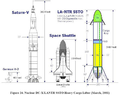
Re: Indian Space Program Discussion
The AVATAR is supposed to bring the cost to 67$ , but it is only for payloads of 1000Kg.
SSTO with nuclear power is risky and is not the same as safety(technical capability) as in power generation . Most importantly ISRO budgets are frugal compared to those of NASA, we are actually getting more than what we are paying for......
SSTO with nuclear power is risky and is not the same as safety(technical capability) as in power generation . Most importantly ISRO budgets are frugal compared to those of NASA, we are actually getting more than what we are paying for......