Re: Indus Water Treaty
Posted: 17 May 2010 06:22
Ajit, welcome to BRf.
Consortium of Indian Defence Websites
https://forums.bharat-rakshak.com/
On Kishanganga:
Building on a Treaty
Author: Sam Burgess
16 May 2010 - Issue : 885 ............................
As the treaty mandates broad Pakistan approval for Indian works on the Western rivers, they used the opportunity to raise number of objections leading to considerable delays in implementation of the projects. The Sallal, Yuri, Dul Hasti and Baghlihar all run-off-river hydro-power schemes without any storage requirements were delayed with Pakistan questioning every aspect of the schemes like technical specifications, data on water flows etc.
In all the cases of objections, the Pakistani argument has been that sudden pondage and release of such waters could be used by India to dry up lower course of Chenab or cause floods that would render Pakistan economically and strategically vulnerable. The argument has no basis and those who know the geography and terrain of Valley would know that such a measure would damage India before it causes any hardship to Pakistan which is 110 Kms down the river course.
Read it all:The latest objections of Pakistan relate to the Kishanganga Project on a tributary of Jhelum which is also a run-off-the-river hydro electric project. The project involves channelling of waters of the Kishanganga tributary, which is known in Pakistan as Neelam, to feed the hydro-power project and the waters later re-join the Jhelum river in Pakistan. Total quantum of flow of water will not be affected. This is as permissible by the treaty and the project was initially proposed in the period during 1991-93. However, Pak-sponsored terrorism prevented its construction. It was proposed again in 2003 and again delayed due to terrorist activities. Pakistan was notified yet again last year about the taking up the project. Pakistan, therefore, is hurriedly putting up, with Chinese assistance, its own power project on the Neelam, north of Muzafferabad, to pre-empt the Kishanganga Project.
Pakistani objections to Kishanganga hydro-power project are based on claims that there will be 27% of water shortage in the tributary in the Neelam valley affecting irrigational use. Indian side provided data showing that flow reductions in the tributary during specific periods will only be 15-16% and this would not affect current pattern of use in the valley. Pakistan also claimed that 1.3 lakh hectares are under irrigation under the tributary, but was not able to show it when Indian experts visited the area, three times in 1991, 1996 and 2008. As Pakistan did not have a strong case to force the halting of Kishanganga project, it is creating a frenzy of orchestrated propaganda involving even terrorist groups with threats of launching suicide bombings and even nuclear attacks on Indian projects. Instead, it serves them better if they provide required data on their claims to Indian side for mutually beneficial negotiations or refer to a neutral expert for a ruling if they strongly feel of having a reasonable case.
Some might like to think that if India abides by the treaty provisions, TSP may not raise dispute. That is only wishful thinking. TSP has raised objections on each and every project of India and that includes Eastern Rivers as well to which India has exclusive rights.It was decided that the previous Pakistan team headed by Professor James Crawford that had fought the legal battle against India on Baglihar Hydropower project will fight the case on Kishanganga hydropower project.
The said decision has reportedly been taken in the two-day meeting which ended on Friday. Minister for Water and Power Raja Pervez Ashraf chaired the meeting while Secretary Water and Power Shahid Rafi, Special Assistant to Prime Minister on Water issues Kamal Majidullah, Pakistan Commissioner of Indus Water Syed Jamaat Ali Shah, Attorney General Justice (R) Maulvi Anwar-ul-Haq and concerned officials of Ministry of Foreign Affairs, Law and Justice, Nespak, Pakistan Army and ISI attended the meeting and discussed the strategy on legal battle in the ICJ.
Pakistan on April 19 has forwarded two names to India for the constitution of the arbitration court. India would also propose their names and then both the countries would agree upon on the name of chief of the arbitration court. The constitution of the court will take place within another five to eight months.
Some independent experts are of the view that Pakistan has delayed to move the international court as India has already managed to substantially construct Kishanganga project. According to some reports, India has completed 80 per cent construction on the project which was initiated by mid 1990s.
However, the physical work on Neelum-Jhelum hydropower project was initiated in 2007 and according to Wapda, about 15 per cent work has been completed. In case India completes its project earlier than the completion of Neelum-Jhelum, then it will clinch the water priority right of Neelum River.


Well I have revised the post. Thanks for clarificationSSridhar wrote:On the Kishenganga project. there are many under a wrong impression that India must complete its works before the Pakistanis. That is completely wrong. The IWT is very clear. It says that any existing Pakistani hydroelectric project should not be adversely affected.
Pakistan did not have an 'existing' project when India made its intentions known about the Kishenganga project. Secondly, even if there is such a project, India, must ensure that the Pakistani project is not adversely affected; that's all.

A_Gupta wrote:I started drawing a diagram of Baglihar and then I got it. Didn't quite tidy up the diagram, though.
Only in one instance of objection was Pakistan after a smaller dam. In all other cases, it is not the amount of storage that worries Pakistan. It is India's leeway in varying the flow of the river. Notice that India would have to violate the IWT to play games with the water flow; but assuming that India wants to violate the treaty, certain dam design characteristics make India's task easier.
Let me explain: (all elevations in meters above sea level).
(3) Therefore the dam must be capable of discharging that much water safely. Pakistan's first demand was that the dam not have gates (i.e., the flood water must discharge by overflowing). But for 16,500 cubic meters to discharge by overflowing, the water level must be 12m above the top of the dam, so the dam maximum height can only be 840m - 12m = 828m.
The Neutral Expert rejected this as reducing Baglihar's hydroelectric potential too much and also as being contrary to modern engineering. All modern dams with more than 14,000 cubic meters/sec discharge have gates.
Gates, by providing an opening at a lower level in the dam, allow for sufficient discharge without overflowing the dam.
(4) Now, the lower the gates, the more the volume of water India can play with. E.g., if the gates were at the base of the dam, then the entire reservoir can be discharged. Or India can empty the reservoir to the bottom sill of the gates, and then close the gates and accumulate water not letting any water downstream. Again, if the gates were at the bottom of the dam, India could empty the reservoir and then accumulate some 400 million cubic meters of water, not letting a single drop reach Pakistan. So Pakistan wants the gates as high as possible.
The Neutral Expert found India's design OK, but actually wanted the sluice gates lowered by 8 meters (contra Pakistan) for the safety of Pul Doda town.
(5) The Dead Storage (the water India cannot use) is some 385 million cubic meters. Pakistan wasn't worried by that. Pakistan wanted the live storage - the pondage - to be 6.22 million cubic meters. India's calculation was 37.5 million cubic meters. The live storage is calculated by the formula in the IWT treaty, that it can be twice the amount needed to level out the fluctuations in the demand for power. I.e., when during the time of day when power demand is high, the power intake will use more water than when the power demand is low, and there must be a buffer to smooth this out compared to the slower rate of change of river inflow.
Notice that the larger the pondage, the more India can control water flow, i.e.., India can start from a position at dead storage level, and withhold water till the pondage is filled.
The Neutral Expert reduced the pondage to 32.56 million cubic meters, and raised the dead storage level by 1 meter to 836m.
The dead storage increases to some 390.39 million cubic meters. (Again, dead storage is not what concerns Pakistan).
(6) Likewise, the lower the power intake the more leeway India has to play with water flow. India had the intake at 818m, the Neutral Expert raised it by 3m. Note that there are engineering reasons for having the intake sufficiently below the surface. India's design had the intake 17m below dead storage level; the Neutral Expert changed that to 15m.
(7) India had the crest of the dam 4.5m above the full pond level. This is a safety margin, to be able to handle e.g., the possibility of a malfunctioning of a spillway gate - the water level will rise somewhat till the increased water pressure causes sufficient discharge from the remaining gates, but the dam will not overflow.
The Neutral Expert reduced the margin to 3m, so the dam crest is 843m above sea level instead of 844.5m. But remember, he also lowered one set of gates from 808 to 800m.
and I must link to flickr, so
http://www.flickr.com/photos/macgupta/4 ... 1/sizes/l/

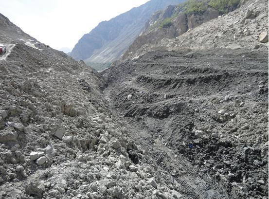
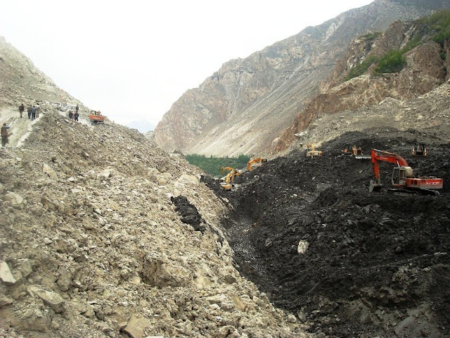
KARACHI, Pakistan - The damage to Pakistan's already fragile economy caused by a landslide blockage of the Karakoram Highway (KKH), the country's key landlink with China, is mounting, with the evacuation this week of Sost, the land port on the border between the two countries.
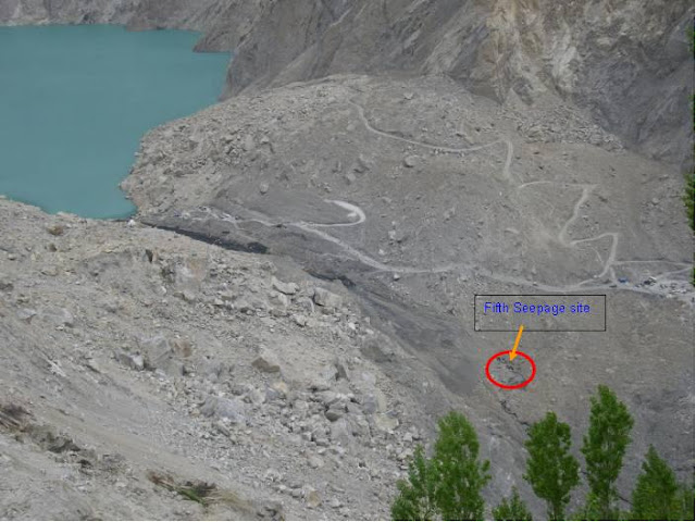
Continuing heavy rains in the mountainous Gilgit-Baltistan area and melt-waters from surrounding glaciers have brought fresh landslides and further raised the level of a vast lake - now 16 kilometers long - that has built up behind the initial blockage at Attaabad, about 750 kilometers north of Islamabad. The level of the lake at Attaabad has reached 97 meters, according to Dawn newspaper last week, citing the National Disaster Management
The rising waters have already have submerged parts of Gulmit, a tourist resort that has become an import money earner for the Hunza valley area in Gilgit-Baltistan since it opened in the mid-1980s. The lake has washed away two bridges in Ghulkin and Hussain, on the Karakoram Highway, and cut off three villages, Dawn reported on Sunday.
Downriver, where the Hunza flows into the Indus, about 11,000 families in Battagram, Mansehra, Shangla and Kohistan may have to be evacuated, the report said, citing the Provincial Disaster Management Authority. "We are preparing for a caseload of 40,000 [people] who could be affected by flooding," Nadeem Ahmed, chairman of national disaster management authority, told a press conference in the capital.
Flooding would put at risk 13,500 people downstream and about 25,000 people upstream who were "less threatened", he said. Meanwhile, large rockfalls continue in the area, one as recently as May 12 (for video, see here ) raising fears that one could block slipways being built to allow runoff from the lake. [1]
A 22km section of the Karakoram Highway has reportedly been washed out since the initial blockage by a huge landslide, put at 2km long, in early January, halting overland trade with China. Damage to the highway has increased transportation costs of goods between the two countries and is driving up prices of essential goods in the Upper Hunza, or Gojal, valley. The valley borders with the Xinjiang-Uyghur region of People Republic of China and Afghanistan.
With rain continuing to pour across the Hunza valley and water in the Attaabad lake rising by as much as a meter a day, scores of villages downriver are threatened by a possible breach of its banks. Residents from more than 36 villages have already been evacuated to safer places.
Shahid Siddiqui, Director of the Center for Humanities and Social Sciences at Lahore School of Economics, writing on his Internet blog, said that "the most painful part of the issue was the downplaying of the disaster by the federal and local authorities. They tried to create the impression that everything was either all right or under control. The reality, however, was just the opposite."
He said no help had been sought from China to meet the challenge, countering other reports that a Chinese engineering company had been called in to assist.
Strategically located Gilgit-Baltistan is seen by both India and Pakistan as part of the larger Jammu and Kashmir issue, which has not yet been resolved. Last year, Islamabad approved a package of self-governance reforms for what was then known as the Northern Areas, aimed at giving it full internal autonomy but without the status of a province.
China is playing a central role in efforts to develop the Gilgit-Baltistan region, with Chinese companies and engineers involved in major hydropower projects in the region, including the Bunji and Basha dams and the Kohala and Neelum-Jhelum hydroelectric projects.


AjayT, that id is unavailable; there is already another user. Suggest another name if you want.AjayT wrote:Sridhar can you change my Id name ti just "Ajit"
Pakistan has sent a note verbale to India on May 17 on the disputed Kishanganga project, clearly indicating its intention to set up a Court of Arbitration as provided in the dispute settlement mechanism under the Indus Waters Treaty (IWT).
This was disclosed here on Thursday by Foreign Office spokesman Abdul Basit. This is the second note verbale that Pakistan has sent to India in two months over the project in Jammu and Kashmir. The first one was sent on April 9 where it informed India of its decision to invoke Article IX of the IWT to seek World Bank arbitration.
India till date has not responded to Pakistan's first note verbale in which Islamabad has asked New Delhi to decide on its two negotiators for the arbitration process and also inform the World Bank about the need to appoint a neutral expert as the two countries have been unable to resolve differences within the Permanent Indus Waters Commission.
The second note verbale, according to Foreign Office officials, has to do with disputes relating to water flows while the first was about “differences” over technical issues of the project. “We hope India would respond positively so [that] we can proceed ahead and have our differences and disputes over the Kishanganga project resolved amicably.”
Army takes over Hunza relief operationISLAMABAD: The overflowing Hunza lake does not pose any threat to Tarbela dam which has sufficient capacity to store additional water.
Sources in the Indus River System Authority said the water level in Tarbela currently stood at about 1,388 feet, just above the dead level of 1,378 feet, that meant it still had more than 160 feet of capacity to be filled.
They said the storage level could be raised by 10 feet a day till such time it reached 1,500 feet.
When Tarbela’s storage level crosses 1,500 feet, safety requires it to be filled at the rate of two feet a day.
The sources said Wapda had not intimated it about any decision to release water from the dam in anticipation of any unusual water inflows.
On Tuesday, Irsa increased water releases to Sindh from 60,000 cusec to 70,000 cusec to meet its additional irrigation requirements and Balochistan’s share has been enhanced to 6,000 cusec from 2,000.( preparing the dam for disaster)
The sources said a delay in undertaking a study to assess the impact of rising water level at Hunza had fuelled apprehensions that the lake might overflow and people in large areas in downstream Hunza had moved to other places.
They said the water level at Hunza had increased to 314 feet and the lake had expanded to over 15 kilometres.
The sources said an official of the federal flood commission who had supervised the study had been sent to the National Disaster Management Authority on deputation despite initial opposition by the NDMA.
Two army helicopters started airlifting over 500 people of Gojal who were stranded in Aliabad because of suspension of boat service since Sunday. The army also transported floating bridges to sites where flood could damage the bridges.
He asked the authorities to immediately post a doctor in Shishkat. The Baitul Mal’s chief announced a grant of Rs50,000 for each affected family. The new Chairman of the National Disaster Management Authority (NDMA), Lf-Gen (retd) Nadeem Ahmed, visited the affected areas to oversee preparations to deal with an emergency.
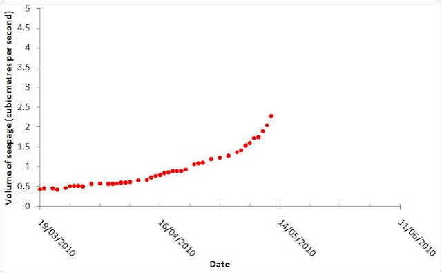
According to experts, water inflow into the lake has reached 3,500 cusecs, with seepage of 150 cusecs, increasing the level by an average of 3.4 feet daily.
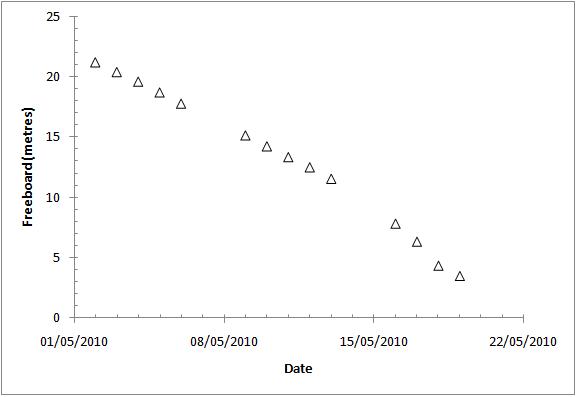
The 18kms-long lake has gained a maximum depth of 361 feet. About 12 feet of free board remains to be topped by the water from the spillway.
According to the experts, since the structure of the spillway was very narrow, the water level in the lake would continue rising for three days even after start of the release from the lake.
Now Pk has taken two steps at the same time one for NE and another for COA to take care of differences and disputes. If NE is to be appointed than Pk has technical issues to be resolved and the very basis for construction of KG DAM has to be accepted. In such a situation raising issues in COA would become infructuous. Although there is no specific bar in IWT to pursue both course of action, but raising one may preclude other.It looks like PK wants to keep both option open and try to stall the work as diversion tunnel is almost complete.Jamaat Ali Shah, Pakistan's Indus waters commissioner, said the country is now seeking formal arbitration proceedings—a treaty mechanism that neither side has used before—because it feels India is stalling on the Kishanganga dispute.
[INDIPAK]
Pakistan on Wednesday named two members that would sit on a seven-person arbitration panel. Under the treaty, India has 30 days to name its own two members, and the countries are supposed to jointly name the three other participants. If they can't agree, the World Bank would step in to name them.
Pakistani farmers and Islamist groups have staged protests against India's 330-megawatt hydroelectric project on the Kishanganga, which is a tributary to one of the rivers Pakistan was allotted under the treaty.
Water availability in Pakistan has fallen 70% since the early 1950s to 1,500 cubic meters per capita, according to a report last year by the Woodrow Wilson International Center for Scholars. India says Pakistan's poor water management is responsible for the water shortages it is experiencing in some regions.
chaanakya wrote:Being part of Kashmir, these people are in fact India citizens living under foreign occupation. IN should highlight their plight and offer to help distressed people in any ways possible, rehabilitation, engineering and army support to clear the landslide, financial support to restart their lives, as indian citizens. Publicly, PK's apathy towards these people should be highlighted. Too much to ask for, given the thaw from thimpu
Under the project, India proposed to divert Kishanganga waters to another tributary of Jhelum, namely Bonar Madmati Nallah, which falls in Wullar Lake and joins the Jhelum thereafter.
Pakistan has objected to this saying that under the provisions of the treaty, India is “under obligation to let flow all the waters of the western rivers and shall not permit any interference with these waters.” It claims that India's plan to divert waters cause obstruction to the flow of Kishanganga.
India maintains that Pakistan has not established any existing hydroelectric or substantial agriculture use, therefore, India was entitled to construct the Kishanganga project.
Pakistan has also raised objection to the depletion of dead storage level in the proposed run of the river Kishanganga project. India maintains that, in the Baglihar dam, also constructed by India in Jammu and Kashmir, the neutral expert had given the verdict that for proper operation and maintenance of the reservoir, depletion below dead storage level was necessary to flush out the silt.
The Pakistan and Indian Indus Commissions are scheduled to hold their annual meeting at the end of the month but the Kishanganga project is not on the agenda so far.
ajit_tr will do if it possible...SSridhar wrote:AjayT, that id is unavailable; there is already another user. Suggest another name if you want.AjayT wrote:Sridhar can you change my Id name ti just "Ajit"
and in all future projects.proper operation and maintenance of the reservoir, depletion below dead storage level was necessary to flush out the silt
Current NDMA dataPakistan has a history of formation and catastrophic failure of landslide dams. Ken Hewit, a Canadian geomorphologist, has documented more than 35 natural dams formed in Karakoram-Himlayas of northern Pakistan in the past 500 years. Whereas a great majority of these formed in response to glacier surges, half a dozen of the natural dams formed in response to landslides. Amongst the historic landslide dams, an event at Raikot-Astor (Nanga Parbat) blocked the Indus River for more than six months with a catastrophic breach in June 1841 causing 25 m high devastating floods all the way to Attock. A Sikh army camped downstream from Tarbela was caught unaware resulting in causality of 500 soldiers. Another massive landslide dam and outburst occurred on Hunza River (some 4 km downstream from the site of the present-day Attaabad landslide dam) in 1858 when exceptionally high floods were again recorded at Attock. The same location was site of another landslide dam and outburst flood in 1962 but with lower intensity levels.
Once established that the Attaabad landslide dam is rated potentially unstable, the next question is when and how it is going to fail? Historic data from the Indus and Hunza rivers (1841 and 1858, respectively) suggest that landslide dams in these high-energy rivers have not survived more than 10 months at the maximum, depending upon the number of summer months involved. Glacial-melting induced water inflow in impounded lakes is so enormous that survival of any natural dam is questionable.
.. The 1929 outburst flood from a natural dam on Shyok River was thoroughly documented and monitored up to some 1500 km downstream by Gunn (1930) and Mason (1932). According to these observations, the maximum flood rose to 13-26 m high in narrow gorges and 7-10 m in wide parts of the Indus River valley. Interestingly, flood levels rose to 7-8 m at Tarbela and Attock, respectively 1120 and 1194 km downstream from the outburst dam. This is almost identical to flood levels at Skardu at a distance of 500 km from the breached dam. This implies that flood levels rise 2-3 times higher in narrow gorges compared to places where valley floor is wide. Most importantly, Ken Hewitt (based on observations from Gunn, 1930 and Mason, 1932) concludes that “over much of their course in the mountains, the recorded (outburst) floods reach heights well above peak discharges from summer melting”.
Height of Water surface from River bed - 352 Ft
Length of Reservoir - 18.5 Kms
Rise in last 24 hours - 2.48 ft
Seepage of water - 186 Cusecs
Free Board - 3.1 M
Inflow - 2700 Cusecs
Expected time of over flow is likely b/w 23-25 May 2010.
vic, that was a decision based on several factors such as silt load, downstream geography, the width of the river at the top and the bottom, international practices etc. It was a very technical decision, but, let me simplify it as I understood.vic wrote: Repeating my question
The obvious question would be that "why India did not design for sluice gates at the bottom". If the sluice gates are for emptying the dam and washing away the silt then that would have been better, isn't it? Won't the level upto the bottom of sluice gate sill / dead level pondage will ultimately be silted up? what is the benefit of dead level pondage at all?
Annexure D, Part 3 of IWT states the following:After threatening to move World Bank over Kishenganga project, Pakistan is set to rake up with India the issue of two more hydel power units being constructed in Jammu and Kashmir when Indus Water Commissioners of the two countries meet here on May 31.
“Pakistan has objections to construction of the Uri-II and Chutak hydel power projects and they will raise the issue during regular meeting of the Indus Water Commission,” a source told PTI today.
Pakistan alleges that these two projects violate the 1960 Indus Water Treaty that governs rights of the two countries on six common rivers.
India maintains that there is no violation of the treaty and is expected to demonstrate this at the upcoming meeting.
The 240 MW Uri-II hydel power project is being constructed on Jhelum river in Kashmir valley.
The 44 MW Chutak project is being constructed in Kargil district of Jammu and Kashmir’s Ladakh provice and would harness the hydropower potential of Suru river.
The barrage of the project is located near village Sarzhe and the power house is proposed on right bank of river Suru near village Chutak.
Pakistan claims that the construction of the Chutak project would block 35,000-feet per acre water.
According to Pakistan, India had given it certain time to respond to designs of these two projects but started construction work before the deadline for Pakistan’s response.
We know that Pakistan does not understand design calculations easily and they go over their head (as Jamaat Ali Shah, PPIC, himself admitted to at Roorkee during the Baglihar deliberations). So, they were probably still groping their way around the Indian design documents when suddenly the three month period elapsed and India started the work. This was most probably the scenario. Applying the Ayub Khan ratio of 1:10, Pakistan might demand 30 months to understand the design.9. To enable Pakistan to satisfy itself that the design of a Plant conforms to the criteria mentioned in Paragraph 8, India shall, at least six months in advance of the beginning of construction of river works connected with the Plant, communicate to Pakistan, in writing, the information specified in Appendix II to this Annexure. If any such information is not available or is not pertinent to the design of the Plant or to conditions at the site, it will be so stated.
10. Within three months of the receipt by Pakistan of the information specified Paragraph 9, Pakistan shall communicate to India, in writing, any objection that it may have with regard to the proposed design on the ground that it does not conform to the criteria mentioned in Paragraph 8. If no objection is received by India from Pakistan within the specified period of three months, then Pakistan shall be deemed to have objection.
Chanaakya, all open source information only.chaanakya wrote:Looks like you were in CWC. . .
Steep rise in water lossesThe government of Punjab has stopped its representative from attending meetings of the Indus River System Authority and has accused Irsa of having turned “blatantly pro-Sindh” and harming the federation.
As a controversy rages among provinces over their share of water, losses in the irrigation system have increased to 50-60 per cent because of rising temperatures and theft......water losses between Taunsa and Sukkur barrages that stood at about 12,000 cusecs on Saturday suddenly increased to over 35,000 cusecs on Monday.
Me thinks that even if Paki allegations were true, Pakis have missed the deadline so their protests are meaningless now.SSridhar wrote:PIC Commissioners to meet
According to Pakistan, India had given it certain time to respond to designs of these two projects but started construction work before the deadline for Pakistan’s response.
Well , reasoning may be in public domain, the way of presentation is not.It comes by deep study, few could master.SSridhar wrote:Chanaakya, all open source information only.chaanakya wrote:Looks like you were in CWC. . .
I hope they remain committed to the schedule.None of this is in any violation of IWT.Chutak H.E. Project (44MW), Jammu & Kashmir
· Barrage & Power House excavation completed and concreting is in progress.
· HRT excavation completed and lining is in progress.
· Power house excavation completed & 29% concreting completed.
· Other Design, Engineering & Fabrication works are in progress.
· The project is expected to be completed by February, 2011.
.......
6. Uri H.E. Project Stage-II (240 MW), Jammu & Kashmir
· Dam excavation & concreting completed. HRT and Power House excavation completed and concreting under progress.
· TRT excavation almost completed and overt lining in progress.
· Erection of EOT Crane in Service Bay and in Unit-1, 2 & 3 has been completed.
· Other Design & Engineering and fabrication of E&M (Electrical& Mechanical) and HM (Hydro Mechanical) works are in progress.
· The project is expected to be commissioned by February, 2011.
I liked the rebuttal. The Indian High Commissioner to Pakistan, H.E. Sharath Sabharwal, ripped apart the bogus Pakistani claims and accusations at the Karachi Chambers of Commerce speech. Now, this letter from the First Secretary there. India is responding to every false claim & lie from Pakistan.abhishek_sharma wrote:Indus water: India’s version
Besides, Baglihar was not a legal issue. It was a technical issue. India was legally allowed to build BHEP. Pakistan challenged India on technical matters.The writer states that Pakistan has “lost cases before neutral experts, whereas the fact is that neutral experts never had the legal competence to grant victory to Pakistan.”
In the 50 years of the treaty, only once an issue ( Baglihar)was referred to a neutral expert. Therefore, reference to ‘lost cases’ before ‘neutral experts’ does not square up with the reality.
NHPC is all set to add another 120 MW by next month with the commissioning of Sewa-II Project in Jammu and Kashmir.
