The Strategic Issues & International Relations Forum is a venue to discuss issues pertaining to India's security environment, her strategic outlook on global affairs and as well as the effect of international relations in the Indian Subcontinent. We request members to kindly stay within the mandate of this forum and keep their exchanges of views, on a civilised level, however vehemently any disagreement may be felt. All feedback regarding forum usage may be sent to the moderators using the Feedback Form or by clicking the Report Post Icon in any objectionable post for proper action. Please note that the views expressed by the Members and Moderators on these discussion boards are that of the individuals only and do not reflect the official policy or view of the Bharat-Rakshak.com Website. Copyright Violation is strictly prohibited and may result in revocation of your posting rights - please read the FAQ for full details. Users must also abide by the Forum Guidelines at all times.
If the airplane searches locate floating debris, and oceanographers calculate where it originated, the next step would be to use robot submarines to scrutinize the ocean floor. Mr. Purcell said the Woods Hole drone submarines, like the Remus 6000, travel about four miles per hour, covering a little less than a mile in width if the sea floor is smooth. They were not built with this purpose in mind. (In fact, this week the Remus 6000 was gathering clam larvae, Mr. Purcell said.)
In search work, the submarines follow a pattern like a lawn mower, laboriously tracing back and forth. The search area is now over two million square nautical miles, but would have to be narrowed to about 5,000 square miles before it would be sensible to use the submarines, he said.
The cockpit voice recorder, important in any investigation and crucial when a hijacking or other crime is suspected, would probably not be useful, one investigator said, because it is a two-hour loop, and the plane flew for hours after leaving its planned route. The boxes originally captured 30 minutes, on a loop of audiotape, but in 1999 the Federal Aviation Administration endorsed the idea of going to two hours. The recording is now on microchips.
March 11 - INMARSAT completes its data analysis
March 12 - morning of March 13 : Depending on whom you believe, the information reaches the Malaysian govt.
Malaysia's government, concerned about corroborating the data and dealing with internal disagreements about how much information to release, didn't publicly acknowledge Inmarsat's information until March 15, during a news conference with Prime Minister Najib Razak. Malaysia began to redirect the search effort that day to focus on the areas the information described, and said for the first time that deliberate actions were involved in the plane's disappearance.
Inmarsat officials, meanwhile, became concerned the data weren't being acted upon quickly enough to help overhaul the search, according to a person familiar with the sequence of events.
The NRO which is the Nation Reconnaissance Office donated two satellites to NASA that were superior to the Hubble Telescope. From the Wiki page..
NRO's technology is likely more advanced than its civilian equivalents. In the 1980s the NRO had satellites and software that were capable of determining the exact dimensions of a tank gun.[18] In 2011 the agency donated two space telescopes to NASA. Despite being stored unused, the instruments are superior to the Hubble Space Telescope. One journalist observed, "If telescopes of this caliber are languishing on shelves, imagine what they're actually using."[41]
why cant we see some of these images. Everyone is showing off their sasquach sightings instead. if what china showed is the best they got, a lot of people are laughing at them just as much as malaysia. Google has 100ft equivalent, something reasonable wont reveal any secrets.
So plane was flying in the Dark Territory without radar coverage? Aus FIR and ATC was not alert and/or it was beyond their range. There was not other option but to crash or belly land. Plane was flying and its comms/transponders where deliberately disabled. Why a hijacker would fly to nowhere in the middle of ocean with nowhere to land? If they wanted to commit suicide spectacularly this was most unlikely of all places.
If Pilot wanted to commit suicide then why fly all the way here? So something happened after it crossed Malaysia penang where Military radar last sighted and plane flew on its own ( auto pilot in cruise mode maintaining heading only no way point nav) till it ran out of fuel and crashed.
Debris must have scattered in narrow zone of point of impact and may be two or three large pieces of fuselage would be clustered at the point of impact. Means it would not have exploded in mid air. Pax would be unconscious or dead right from the beginning when plane flew above its rated ceiling .
There may be a way to tell if the passangers were dead BEFORE the plane hit the water.
If they died before, it is possible they will not imbibe a lot of plankton and sea-water into their lungs (Because they were not breathing)
The above is SOP for determining weather a person died due to drowning or was dead before the body hit the water.
But the bodies have been in the drink for upwards of 10 days now. They have probably been eaten by the fishes by now...
Everyone is trying to 'galaoo their daal' here.
Can't believe that the cheeni are phools of this magnitude! They released photos that everyone in the world is laughing at - they were tlying to be showing off their Supel-doopel saterrite technorogy to the world!
Then they were fighting like two teenager boys with the malaysians
Now they are asking India if they can send some oceanographic ships into Indian waters to "Look phol the prane onlee"
Aus,vietnam, india and Sher Khan comes across as far more professional in these matters. trying to help putting aside the budding superpawa and asian tiger psycho plays.
chaanakya wrote:So plane was flying in the Dark Territory without radar coverage? Aus FIR and ATC was not alert and/or it was beyond their range. There was not other option but to crash or belly land. Plane was flying and its comms/transponders where deliberately disabled. Why a hijacker would fly to nowhere in the middle of ocean with nowhere to land? If they wanted to commit suicide spectacularly this was most unlikely of all places.
If Pilot wanted to commit suicide then why fly all the way here? So something happened after it crossed Malaysia penang where Military radar last sighted and plane flew on its own ( auto pilot in cruise mode maintaining heading only no way point nav) till it ran out of fuel and crashed.
Debris must have scattered in narrow zone of point of impact and may be two or three large pieces of fuselage would be clustered at the point of impact. Means it would not have exploded in mid air. Pax would be unconscious or dead right from the beginning when plane flew above its rated ceiling .
If it ran out of fuel I guess there would definitely be no major explosion/fire. but I'm curious. I have read about fighter pilots who have run out of fuel - but most often they are single engined. In the case of twin (777) or multi engine I really wonder if both engines will flame out at exactly the same moment. Chances are that one will go out a few seconds or (or maybe a minute) before the other. That means that the plane will yaw violently to one side and with no one to throttle back and adjust trim the plane will spin out of control and fall out of the sky.
The young woman who spent an entire flight in the cockpit hanging out with the pilots of a Malaysian Airlines plane in 2011 says it was 'scary and eerie' to learn one of the men was flying MH370 when it disappeared.
Jonti Roos, a South African currently living in Melbourne during a year-long stay in Australia, revealed last week she and her friend Jaan Maree were plucked from the queue while waiting to board a flight from Phuket to Kuala Lumpur and asked if they would like to ride up front.
Fariq Abdul Hamid, 27, the co-pilot of missing Malaysian Airlines flight MH370, spent the flight smoking in the cockpit and chatting with the two girls, Ms Roos claims.
Gosh 43 deg lat will be cold and dark at this time of year. OK Maybe not dark I guess.
first p3 finds nothing -- rain/weather.
the slide show was posted early on. nothing unusual for many airlines even these days, no reflection on copilot skills. young lady wanted her 15 minutes of fame rather than mh370 concern. if anything shows copilot to be non-religious.
Is that real ping data or an interpolation of some kind? because the accompanying text seems to suggest an interpolation by private parties not NTSB or Malaysian govt.
Last edited by Harpal Bector on 20 Mar 2014 15:20, edited 2 times in total.
chaanakya wrote:So plane was flying in the Dark Territory without radar coverage? Aus FIR and ATC was not alert and/or it was beyond their range. There was not other option but to crash or belly land. Plane was flying and its comms/transponders where deliberately disabled. Why a hijacker would fly to nowhere in the middle of ocean with nowhere to land? If they wanted to commit suicide spectacularly this was most unlikely of all places.
If Pilot wanted to commit suicide then why fly all the way here? So something happened after it crossed Malaysia penang where Military radar last sighted and plane flew on its own ( auto pilot in cruise mode maintaining heading only no way point nav) till it ran out of fuel and crashed.
Debris must have scattered in narrow zone of point of impact and may be two or three large pieces of fuselage would be clustered at the point of impact. Means it would not have exploded in mid air. Pax would be unconscious or dead right from the beginning when plane flew above its rated ceiling .
If it ran out of fuel I guess there would definitely be no major explosion/fire. but I'm curious. I have read about fighter pilots who have run out of fuel - but most often they are single engined. In the case of twin (777) or multi engine I really wonder if both engines will flame out at exactly the same moment. Chances are that one will go out a few seconds or (or maybe a minute) before the other. That means that the plane will yaw violently to one side and with no one to throttle back and adjust trim the plane will spin out of control and fall out of the sky.
It looks like the jetliner was on autopilot and if so the FMS will adjust for single engine condition.
If the Malaysians did not get even one crank call or email claiming responsibility for a hijack, then that would be very unusual. It suggests a spam filter that is set far too high.
Did the Malays ignore any demands for ransom because they found the source less than credible?
^^ I would imagine on a normal scenario auto pilot without way points sound pointless. Then in that case, the plane gunning for a radio black out area should rule out the auto pilot scenario, isn't it?
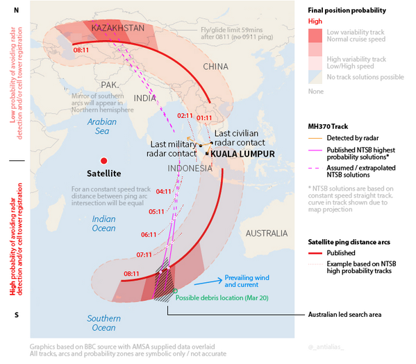
Tim Farrar, a former systems engineer in California who advises companies on satellite and telecommunications issues, said the investigators appeared to have identified the broad area where the jet may have fallen into the southern Indian Ocean by building from the plane’s final “ping” signals to a satellite and using the bleak assumption that it was flying at an undeviating speed toward the Southern Ocean and, ultimately, Antarctica.
Gupta ji someone on flightradar seems to have actually used the same method to plot the north route as suggested by you:
oops sorry too big - someone please help to make it smaller
saravana wrote:If it was on auto pilot, would it still pass through way points or it just goes straight and level?
That depends
From Boeing Manual:
If Flight Director Switch is ON then Autopilot engages in Select Flight Director Mode i.e. Heading Hold or Track Hold as Roll Mode. If Bank angle is more than five deg then Attitude Hold.
Second choice is Vertical Speed Hold or flight path angle hold as pitch mode.
If it was in cruise mode then HDG HLD Mode might be selected. Works in combination with GPS and NAV swicth. Therefore , either way points are entered in GPS switch and heading is entered in NAV . If flight plan is entered ( marked way points like the one IGAREX or VAMPI) then flight follows those way-points else heading is followed. When Autopilot detects degradation in flight control it remains engaged in Attitude stabilizing mode based on inertial data.But with engine loss flight envalope would be completely degraded and ECIAS warning would be flashing.
Harpal Bector wrote:If the Malaysians did not get even one crank call or email claiming responsibility for a hijack, then that would be very unusual. It suggests a spam filter that is set far too high.
Did the Malays ignore any demands for ransom because they found the source less than credible?
The newspapers reported that an Uighur group claimed responsibility, but is considered to be crank.
saravana wrote:If it was on auto pilot, would it still pass through way points or it just goes straight and level?
That depends
From Boeing Manual:
If Flight Director Switch is ON then Autopilot engages in Select Flight Director Mode i.e. Heading Hold or Track Hold as Roll Mode. If Bank angle is more than five deg then Attitude Hold.
Second choice is Vertical Speed Hold or flight path angle hold as pitch mode.
If it was in cruise mode then HDG HLD Mode might be selected. Works in combination with GPS and NAV swicth. Therefore , either way points are entered in GPS switch and heading is entered in NAV . If flight plan is entered ( marked way points like the one IGAREX or VAMPI) then flight follows those way-points else heading is followed. When Autopilot detects degradation in flight control it remains engaged in Attitude stabilizing mode based on inertial data.But with engine loss flight envalope would be completely degraded and ECIAS warning would be flashing.
Thanks chaanakya. I guess this should wait for the blackbox then. I don't see how this information is part of engine health check packets.
saravana wrote:If it was on auto pilot, would it still pass through way points or it just goes straight and level?
That depends
From Boeing Manual:
If Flight Director Switch is ON then Autopilot engages in Select Flight Director Mode i.e. Heading Hold or Track Hold as Roll Mode. If Bank angle is more than five deg then Attitude Hold.
Second choice is Vertical Speed Hold or flight path angle hold as pitch mode.
If it was in cruise mode then HDG HLD Mode might be selected. Works in combination with GPS and NAV swicth. Therefore , either way points are entered in GPS switch and heading is entered in NAV . If flight plan is entered ( marked way points like the one IGAREX or VAMPI) then flight follows those way-points else heading is followed. When Autopilot detects degradation in flight control it remains engaged in Attitude stabilizing mode based on inertial data.But with engine loss flight envalope would be completely degraded and ECIAS warning would be flashing.
Way points (for eg, IGAREX or VAMPI) may be quickly select able from a database, instead of entering the coordinates every time.
Who ever changed the way points certainly knew what they were doing. After the change, every thing enters the realm of conjecture due to lack of credible inputs or plausible conclusions backed by some or any evidence.
The pics given to us with those coordinates are from March 16. Estimated drift rate is 16 miles/day (~26 kilometers/day) (per NYT, I think) meaning 50-60 miles further out, though I'm sure the searchers are correcting for all that.
The distance calculators here gives me that the large and small debris are separated by 215 kilometers.
if a fire was slowly eating is way through the avionics bay under the cockpit, maybe the HW becomes "reset" to some wild mode and picks random values as waypoints from scrambled memory .
but probably Capt Zaharie in his last moments managed to program some codes he knew would lead it over the ocean and atleast prevent it killing more people on land. he sounds like the kind of guy who would do it, a high level manager type by title but a individual contributor at heart.
chaanakya wrote:
If it was in cruise mode then HDG HLD Mode might be selected. Works in combination with GPS and NAV swicth. Therefore , either way points are entered in GPS switch and heading is entered in NAV . If flight plan is entered ( marked way points like the one IGAREX or VAMPI) then flight follows those way-points else heading is followed. When Autopilot detects degradation in flight control it remains engaged in Attitude stabilizing mode based on inertial data.But with engine loss flight envalope would be completely degraded and ECIAS warning would be flashing.
Is it possible to get a list of South Indian Ocean waypoints? Just curious, if the entire course of the plane was charted with waypoints, what those likely might be.
I tried without success to find a drawing of the 777 airframe showing the composite panels . imo the wing leading edge, the main wing panels down the center , the roof panels and the tail might be the biggest pieces. which one could be 80ft long - probably only the wing and roof panels....80ft is huge.
Singha wrote:if a fire was slowly eating is way through the avionics bay under the cockpit, maybe the HW becomes "reset" to some wild mode and picks random values as waypoints from scrambled memory .
but probably Capt Zaharie in his last moments managed to program some codes he knew would lead it over the ocean and atleast prevent it killing more people on land. he sounds like the kind of guy who would do it, a high level manager type by title but a individual contributor at heart.
Those way points were fairly close to their normal base and would have been used frequently either incoming or outgoing.
So just two theories survive:
UBCNews CT1: Accident, fault of Malaysian guvrmand and/or someone who scares the wits out of them. Crashed on land, area cordoned off and evidence quickly buried. All witnesses under tight security clampdown.
UBCNews CT2: Hijacked, landed; contents transferred to container ship that is now far away/ already unloaded. Plane hidden in remote island/desert/forest. Can't imagine it being dismantled. All big fires/petroleum smoke/ IR sources in last 12 days would have been seen by satellites and checked out: missile launch sensors are anyway on high alert worldwide given Ukraine situation.
Either way, hope for humans aboard is dim, but in view of CT2, efforts have to continue unabated to look for suspicious signs.
Think back: Malaysia did not announce plane missing until 12 hours after the event. As shiv pointed out, they didn't sound any alarm until several minutes after "gone off radar". Then Vietnamese ATC got some "mumbled response" but don't know what SAR went into effect, and when.
Also don't know what happened at Beijing airport when the plane was overdue, how long it was b4 relatives got any word that plane was missing, not delayed. Check on that, and you can learn a lot about CT1.
Last edited by UlanBatori on 20 Mar 2014 17:23, edited 1 time in total.
