Satellite Communications
Posted: 16 Oct 2011 16:09
Hello BRFites,
There is a thread covering 'Indian Space program', but general subjects like informative communiques on the subject of satellite communications/ orbits etc appear to be out of topic there.
Hence this thread has been started.
As a starting point explaining the TLEs.
( e.g. TLE mentioned in the topic of PSLV C18 launch/ Meghatropiques / Jugnu / SRMSAT.)
The status of the satellite can be totally described if we describe ( at an instant of orbit called as Epoch Time )
1. the shape of orbit
2. How the orbit is positioned around Earth and finally,
3. How is the Satellite is situated in that orbit.
Let's study TLE for Cartosat 2 that was launched in 2007. We find the TLE from this place.
There it lists Cartosat 2 TLE as follows:
CARTOSAT-2 (IRS-P7)
1 29710U 07001B 11289.87789931 .00001006 00000-0 14407-3 0 2742
2 29710 97.8976 348.0802 0002117 70.9435 289.1994 14.78689525257248
What is that????
We find that the satellite has an international standard designation 29710U.
It was launched in 2007 in first launch of the year and it was the second object in that launch. This info is available in 07001B decoded as (07=2007), 001 = 1st launch in 2007 [ launch date 10th Jan 2007 ] and B is the second object in following list that were launched by PSLV C7
2007-001A 29709 LAPAN-TUBSAT INDO 2007-01-10
2007-001B 29710 CARTOSAT-2 (IRS-P7) IND 2007-01-10
2007-001C 29711 SRE-1 IND 2007-01-10 SRILR 2007-01-22 D
2007-001D 29712 PEHUENSAT 1 (PO-63) ARGN 2007-01-10
The extra description against SRE-1 ( It was India's re-entry capsule experiment ) indicates that it fell on earth on 2007-01-22.
A description of how the things are coded is found here.
TLE stands for Two Line Elements .. wherein a basic set of input parameters is put together using which one can ( not easily ) calculate the location of satellite for any time in future. This is a standard format so that one can copy and use as input to most of the orbit calculation programs.
The parameters can be decoded using the link below:
https://docs.google.com/spreadsheet/ccc ... c&hl=en_US
and after using that link we get following list:
Sat Name: CARTOSAT-2
CAT No. 37838
DRAG 0.00001006
BSTAR 14407-3
Incl 19.7947
RA 62.7084
Ecc 0.0060638
Ap 17.8079
MA 342.4581
Mean Motion 14.2066792
Element Set 2742
Rev No. 48
Epoch Time 11289.8779
SMA 7201.23183
Ht abv Eq 823.09
Period 6081.646441
Epoch Year ------------------> 2011
Epoch Day of year---------> 289
EpochTime ------------------> 21:04:10
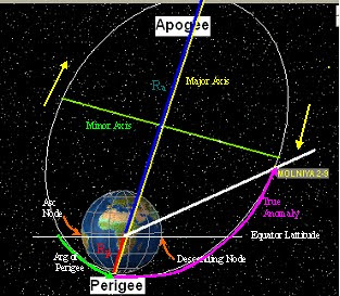
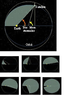
The figure below shows the parameters graphically.
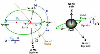
Basically these numbers tell the status of satellite in its orbit around Earth. Orbit is always in a flat plane called orbital plane and the Earth is in its one of the foci.
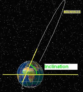
The satellite can be put in any of the following orbits: ( classified with respect to angle between Orbital plane and Equator.)
Equatorial: Where the orbit is over equator. So the angle i ( = inclination ) in above 2nd figure will be = 0 deg.
Polar : Where the orbit is passing near poles. So the angle i will be about 90 deg.
Inclined Orbit : Is in between the above two .. there are other subcategories in this : prograde, Retrograde and a very special called as Molniya which has an inclination angle of 63.4 deg.
We will restrict ourselves with Elliptical orbits.
Epoch time is the time for which the given numbers are measured. ( these numbers together are also called as State Vector because they depict the status of satellite in its dynamic path at that Epoch time ).
In TLE set the epoch time is given as YYDDD.TTTT , YY is the year,DDD day of year from 1st Jan and TTTT is the Time in fraction of day, at which these parameters are listed.
The Orbit in its orbital plane itself has different shapes. The Ellipse may be Thin, Fat, Circular etc. ( these are unscientific words used only for explanation ). This definition of shape is denoted by the Eccentricity. Eccentricity e is a constant defining the shape of the orbit (0=circular, Less than 1=elliptical)
The Apogee and Perigee are the points in the ellipse which are nearest and farthest from the central body. The straight line between Apogee and Perigee will necessarily pass through the central body and that distance is called Major axis.
The other perpendicular axis to Major axis in orbital plane passing through the centre of major axis is Minor axis.
The satellite can be anywhere in the orbital plane and it is denoted by small Omega sign ( called Argument of perigee , the angle between perigee and satellite at the time of Epoch.
The ellipse of the orbit is not stationary but it rotates around the main body.
There is a thread covering 'Indian Space program', but general subjects like informative communiques on the subject of satellite communications/ orbits etc appear to be out of topic there.
Hence this thread has been started.
As a starting point explaining the TLEs.
( e.g. TLE mentioned in the topic of PSLV C18 launch/ Meghatropiques / Jugnu / SRMSAT.)
The status of the satellite can be totally described if we describe ( at an instant of orbit called as Epoch Time )
1. the shape of orbit
2. How the orbit is positioned around Earth and finally,
3. How is the Satellite is situated in that orbit.
Let's study TLE for Cartosat 2 that was launched in 2007. We find the TLE from this place.
There it lists Cartosat 2 TLE as follows:
CARTOSAT-2 (IRS-P7)
1 29710U 07001B 11289.87789931 .00001006 00000-0 14407-3 0 2742
2 29710 97.8976 348.0802 0002117 70.9435 289.1994 14.78689525257248
What is that????
We find that the satellite has an international standard designation 29710U.
It was launched in 2007 in first launch of the year and it was the second object in that launch. This info is available in 07001B decoded as (07=2007), 001 = 1st launch in 2007 [ launch date 10th Jan 2007 ] and B is the second object in following list that were launched by PSLV C7
2007-001A 29709 LAPAN-TUBSAT INDO 2007-01-10
2007-001B 29710 CARTOSAT-2 (IRS-P7) IND 2007-01-10
2007-001C 29711 SRE-1 IND 2007-01-10 SRILR 2007-01-22 D
2007-001D 29712 PEHUENSAT 1 (PO-63) ARGN 2007-01-10
The extra description against SRE-1 ( It was India's re-entry capsule experiment ) indicates that it fell on earth on 2007-01-22.
A description of how the things are coded is found here.
TLE stands for Two Line Elements .. wherein a basic set of input parameters is put together using which one can ( not easily
The parameters can be decoded using the link below:
https://docs.google.com/spreadsheet/ccc ... c&hl=en_US
and after using that link we get following list:
Sat Name: CARTOSAT-2
CAT No. 37838
DRAG 0.00001006
BSTAR 14407-3
Incl 19.7947
RA 62.7084
Ecc 0.0060638
Ap 17.8079
MA 342.4581
Mean Motion 14.2066792
Element Set 2742
Rev No. 48
Epoch Time 11289.8779
SMA 7201.23183
Ht abv Eq 823.09
Period 6081.646441
Epoch Year ------------------> 2011
Epoch Day of year---------> 289
EpochTime ------------------> 21:04:10
The figure below shows the parameters graphically.
Basically these numbers tell the status of satellite in its orbit around Earth. Orbit is always in a flat plane called orbital plane and the Earth is in its one of the foci.
The satellite can be put in any of the following orbits: ( classified with respect to angle between Orbital plane and Equator.)
Equatorial: Where the orbit is over equator. So the angle i ( = inclination ) in above 2nd figure will be = 0 deg.
Polar : Where the orbit is passing near poles. So the angle i will be about 90 deg.
Inclined Orbit : Is in between the above two .. there are other subcategories in this : prograde, Retrograde and a very special called as Molniya which has an inclination angle of 63.4 deg.
We will restrict ourselves with Elliptical orbits.
Epoch time is the time for which the given numbers are measured. ( these numbers together are also called as State Vector because they depict the status of satellite in its dynamic path at that Epoch time ).
In TLE set the epoch time is given as YYDDD.TTTT , YY is the year,DDD day of year from 1st Jan and TTTT is the Time in fraction of day, at which these parameters are listed.
The Orbit in its orbital plane itself has different shapes. The Ellipse may be Thin, Fat, Circular etc. ( these are unscientific words used only for explanation ). This definition of shape is denoted by the Eccentricity. Eccentricity e is a constant defining the shape of the orbit (0=circular, Less than 1=elliptical)
The Apogee and Perigee are the points in the ellipse which are nearest and farthest from the central body. The straight line between Apogee and Perigee will necessarily pass through the central body and that distance is called Major axis.
The other perpendicular axis to Major axis in orbital plane passing through the centre of major axis is Minor axis.
The satellite can be anywhere in the orbital plane and it is denoted by small Omega sign ( called Argument of perigee , the angle between perigee and satellite at the time of Epoch.
The ellipse of the orbit is not stationary but it rotates around the main body.