There are some posts about " number plates reading by satellites "
Is is technically possible to to read a number plate through the atmosphere without seeing the wavy air structure?
How stable should the camera platform ( spacecraft ) be?
Scientific replies please.
Indian Space Program Discussion
Re: Indian Space Program Discussion
soemtimes I think this is one of the american myths propagatd during cold war
to start with the car number plate has to face upward or the satelite has to view it from a very shallow angle so that the image even if radar type can make an comprehensible photo
secondly the maximum or best resolution for imaging sats is around 60 -100 mm say 80 mm fo the indiviadual numbers on the plate has to be that high
add the factor of pollution movement stability of the image taking platform etc and the trafic on road
so all in all I dont think a sat can take a snap shot of a car number plate under normal operating conditions
Re: Indian Space Program Discussion
We dont need to be too hung up on resolution. A resolution of ~5m would still be more than enough for a shot in the arm to make digital maps. Think "TERCOM" and "Nirbhay". I personally am waiting for RISAT-1 to be launched. Would demonstrate domestic capability in SAR and would be the precursor to a wide range of applications. Including Aircraft mounted SAR with GMTI - we might have our own JSTARS-like platform. Think of "AWACS for ground targets".saip wrote:They can see the plate but not read it perhaps. Then again the resolution could be higher than what is being claimed.
Re: Indian Space Program Discussion
The XL version can deliver significantly heavier payload into GTO. The CY-1 craft mass was 1380 KG @ GT0.saumitra_j wrote:IIRC, PSLV can put upto 1000KG in GTO - it has already put Kalpana 1 (METSAT) in GTO.My mistake, how can a PSLV park a sat in the Geo Synch orbit.
Here's the URL for more details.The flight path of PSLV-C4 has been modified to inject the METSAT into a Geosynchronous Transfer Orbit of 250 km perigee (nearest point to Earth) and 36,000 km apogee (farthest point to Earth).
Re: Indian Space Program Discussion
Even at 10 cm resolution, it is impossible to read the licence plates. At 1 metre there is no way.
http://www.fas.org/irp/imint/resolve4.htm
http://www.fas.org/irp/imint/resolve4.htm
-
Bade
- BRF Oldie
- Posts: 7212
- Joined: 23 May 2002 11:31
- Location: badenberg in US administered part of America
Re: Indian Space Program Discussion
In the specific case of a moving car's number plate the complications are immense. The target is in the same plane as the line of sight, looking nadir (at best resolution) and for minimum atmospheric contamination of the signal.SSSalvi wrote:There are some posts about " number plates reading by satellites "
Is is technically possible to to read a number plate through the atmosphere without seeing the wavy air structure?
How stable should the camera platform ( spacecraft ) be?
Even so, how accurately can the atmospheric condition be measure in real time to depict the conditions at the time of observation. Spatial resolution required is like inches and time resolution depends on the speed of the target at a minimum. Can profiling of the various levels of the atmosphere be done at such short event reconstruction times to make it valuable information.
-
Prem Kumar
- BRF Oldie
- Posts: 4749
- Joined: 31 Mar 2009 00:10
Re: Indian Space Program Discussion
The whole "number plate" thingy sounds like a big FUD factor (fear, uncertainty and doubt). Some smart alec Amrikaan must have coined the original term long ago and every DDM reporter has faithfully aped this as the ultimate benchmark for satellite spying.
Question for the gurus: can the RISAT (or for that matter Cartosat) images provide accurate co-ordinate data? Say they detect a Paki bunker, can they pass on its x,y,z data with some level of inaccuracy. So that an Indian artillery commander can direct his boom-boom?
Also, do we know how successful Cartosat 2 has been for military applications? I have read some mentions that its performance has been "unsatisfactory". Not sure if it is DDM or whether there is some truth to it.
Re: Indian Space Program Discussion
Few observations:Bade wrote:In the specific case of a moving car's number plate the complications are immense. The target is in the same plane as the line of sight, looking nadir (at best resolution) and for minimum atmospheric contamination of the signal.SSSalvi wrote:There are some posts about " number plates reading by satellites "
Is is technically possible to to read a number plate through the atmosphere without seeing the wavy air structure?
How stable should the camera platform ( spacecraft ) be?
Even so, how accurately can the atmospheric condition be measure in real time to depict the conditions at the time of observation. Spatial resolution required is like inches and time resolution depends on the speed of the target at a minimum. Can profiling of the various levels of the atmosphere be done at such short event reconstruction times to make it valuable information.So this is a myth that will remain unproven, and only to create a sense of fear.
1). "Indian spy satellite can see number plates of cars":
Seeing Number plate is very different from seeing the imprinted characters. Zimple onlee. Too much reading between the line.
2) >> Is is technically possible to to read a number plate through the atmosphere without seeing the wavy air structure?
Yes of course. Earth based telescopes with adaptive optics do this day in and day out. Space based optics can do the same. Many EOS/Spy sats were sent up last many years with this capabelity. Adaptive optics allows correcting mirror source by faction of a wavelength.
-
Bade
- BRF Oldie
- Posts: 7212
- Joined: 23 May 2002 11:31
- Location: badenberg in US administered part of America
Re: Indian Space Program Discussion
Earth based telescopes looking upward are usually miles above mean sea level...at places like Mauna Kea in hawaii. Space based assets looking at sea level targets have to deal with more of the atmospheric disturbance.  than their astronomical counterparts.
http://en.wikipedia.org/wiki/Astronomical_seeing
http://en.wikipedia.org/wiki/Astronomical_seeing
Re: Indian Space Program Discussion
Military surveillance gets a boost with RISAT-2However, India needs more such satellites and over the next couple of years, it is expected to launch two more satellites built by Israel.
Re: Indian Space Program Discussion
From:
India to get Phalcon AWACS on May 18
India to get Phalcon AWACS on May 18
Does anyone have more information about the military satellite mentioned in the article ?
Jerusalem:
All the six AWACS would be linked with the country’s first military satellite proposed to be launched by mid next year.
Re: Indian Space Program Discussion
Thanks Gerard.
Re: Indian Space Program Discussion
I wish India has many alike who are not ashamed of wearing a dhoti and act truly as a smart but rustic dhoti-walla who will protect its turf/interest vigorously. In the process all Yindian are Chankians onlee.vina wrote:Saar, you are one hell of a very smart and cunning Yindoo. Very Dhoti clad and Chankian onree. I think you are right on the money on this.Arun_S wrote:Key tech satellites are often built in pairs, the second serves as a backup in case of launch failure and and if launch was good it also help troubleshooting the satellite in orbit, by experimenting on the exact replica that is hand in lab conditions. Due to high NRE, the cost of make one sat is almost same as making 2 to 3 sats. I will not surprised if Isreal had made 2 or more of the TECSAR, and had on shelf TECSAR units that was quickly sold to Yindians post 26/11, hence the short turnaround time.
I would like to quote a dhotiwalla who I revere as patriarch:
- Where the mind is without fear and the head is held high
Where knowledge is free
Where the world has not been broken up into fragments
By narrow domestic walls
Where words come out from the depth of truth
Where tireless striving stretches its arms towards perfection
Where the clear stream of reason has not lost its way
Into the dreary desert sand of dead habit
Where the mind is led forward by thee
Into ever-widening thought and action
Into that heaven of freedom, my Father, let my country awake.
Can someone post the original in Bangali script please?
Re: Indian Space Program Discussion
I would like to quote a dhotiwalla who I revere as patriarch:
- Where the mind is without fear and the head is held high
Where knowledge is free
Where the world has not been broken up into fragments
By narrow domestic walls
Where words come out from the depth of truth
Where tireless striving stretches its arms towards perfection
Where the clear stream of reason has not lost its way
Into the dreary desert sand of dead habit
Where the mind is led forward by thee
Into ever-widening thought and action
Into that heaven of freedom, my Father, let my country awake.
Can someone post the original in Bangali script please?
Please see the Bengalee version in the folowing URL
http://nayagam.wordpress.com/2006/02/26 ... hout-fear/
Re: Indian Space Program Discussion
Guardian
Nasa moon launch may be delayed until after 2020
Because of growing budget woes, the US space agency is resetting the target date for the lunar launch
Can we get there before them? Can we become the second nation to reach the Moon?
Nasa moon launch may be delayed until after 2020
Because of growing budget woes, the US space agency is resetting the target date for the lunar launch
Can we get there before them? Can we become the second nation to reach the Moon?
Re: Indian Space Program Discussion
Deleted by sssalvi
request krish to remove the quote.
request krish to remove the quote.
Last edited by SSSalvi on 24 Apr 2009 20:52, edited 1 time in total.
Re: Indian Space Program Discussion
Is it best not to discuss "ghost stories" in an open forum......?
Re: Indian Space Program Discussion
*** Removed ***
RISAT-1 was supposed to be launched then. You are mistaken.
RISAT-1 was supposed to be launched then. You are mistaken.
Last edited by SSridhar on 25 Apr 2009 16:25, edited 1 time in total.
Reason: On author's request
Reason: On author's request
-
Prem Kumar
- BRF Oldie
- Posts: 4749
- Joined: 31 Mar 2009 00:10
Re: Indian Space Program Discussion
Notwithstanding some phenomenal successes of ISRO, I do have a gripe with them. They seem to have drunk quite a few 12-packs of their own "we are civilian only" kool-aid.
The ratio of civilian:military satellites that the ISRO launches is too skewed. Which is very sad for a nation that is under constant threat. If you look at the RISAT2 purchase objectively, the situation is similar in nature to the IAF going for the MRCA tender because LCA is delayed. Obviously this analogy is a stretch: but if this had been the DRDO, you can be sure that it would have gotten a lot of flak.
Now, the ISRO definitely deserves a lot more slack because of their track record, compared to the DRDO. But I cant help feeling that by now we should have launched RISAT1 & at least a couple of IRNSS satellites. Rather we seem to focus on CY2 & manned moon mission. It appears to be a question of wrong priorities, not necessarily capabilities.
Re: Indian Space Program Discussion
Prem Kumar-saarPrem Kumar wrote: If you look at the RISAT2 purchase objectively, the situation is similar in nature to the IAF going for the MRCA tender because LCA is delayed. Obviously this analogy is a stretch: but if this had been the DRDO, you can be sure that it would have gotten a lot of flak.
RISAT2 == TECSAR and the launch contract for TECSAR is quite old. Now consider the hoopla for launching an "Israeli satellite for Israel" as opposed to no hoopla for acquiring arms from Israel for Indian use. Now consider the level of hungama if we were to ever have a weapons system that will be operated and used jointly with Israel. Now revisit your question of "Hasty purchase from Israel for plugging gaps".
There were a bunch of hiccups in RISAT1, the tests were being made on a testbed (a flying cessna IIRC). We will get there soon. As far as IRNSS is concerned, the level of sophistication needed for the precise atomic clocks that is needed is quite a challenge. Such clocks (as opposed to comm/optics gear that were used in INSATs and IRS) are new technology and not an improvement over technology we have already mastered. We are importing the first batch of clocks, (from SpectraTime IIRC which are not yet ready) and will be making our own soon.But I cant help feeling that by now we should have launched RISAT1 & at least a couple of IRNSS satellites. Rather we seem to focus on CY2 & manned moon mission. It appears to be a question of wrong priorities, not necessarily capabilities.
If you follow ISRO's development closely, they dont just want to loft a few satellites in space and hope IRNSS works. They also are trying to provide for a satellite based augmentation system. Project GAGAN (for GPS augmentation) has already been implemented and has provided satisfactory performance so far, the reference stations are up and running and the receivers are being trialed. They are gaining good experience in studying the ionosphere over India. IRNSS is a system and not just a bunch of satellites, So patience please.
-
rachel
- BRFite
- Posts: 143
- Joined: 17 Jan 2008 01:27
- Location: www.canhindu.com
Re: Indian Space Program Discussion
I'll tell you, the only real big disappointment with ISRO's programme so far has been the untimely failure of the ISRO-EADS bird, W2M.
I had been having a discussion with a Chinese acquainitance and had boasted that Chinese were only capable of building low-tech low quality junk satellites for rat-hole countries like Iran, Puki-stan, Venezuela et al. While India is doing so for Europe with EADS.
Gaahhh! The failure of W2M demolished that, and I couldnt show my face to her again.
And it seems EADS is quite angry and upset: they have not announced a second try. I think ISRO blew those opportunities for a while.
Mind you, it may not have been their fault. Integrating an ISRO bus with EADS xponders is tricky.
Would have been better is ISRO had simply been commissioned to build the whole satellite for them.
-
rachel
- BRFite
- Posts: 143
- Joined: 17 Jan 2008 01:27
- Location: www.canhindu.com
Re: Indian Space Program Discussion
It's a stretch from the perspective that part of the DRDO problem is that our military babus often demand unrealistic performance from the likes of LCA, Arjun et al ... partly cuz they want bribes and kickbacks from buying foreign. SO they often try to kill the whole project.Prem Kumar wrote:. If you look at the RISAT2 purchase objectively, the situation is similar in nature to the IAF going for the MRCA tender because LCA is delayed. Obviously this analogy is a stretch: but if this had been the DRDO, you can be sure that it would have gotten a lot of flak.
.
With military the problem is two-fold: DRDO failure to deliver on time, and also armed services greed for foreign bribes encouraging rejection of perfectly good systems.
Whereas with civilian space, no one tries to delay or kill our RISAT on purpose out of greed in buying Israeli or foreign. So RISAT will come for sure, just been delayed a bit. (whereas Arjun and others probably are a pipe dream).
-
Neela
- BRF Oldie
- Posts: 4138
- Joined: 30 Jul 2004 15:05
- Location: Spectator in the dossier diplomacy tennis match
Re: Indian Space Program Discussion
Folks,
Shiv Aroor's blog has a interesting picture.
Indian troops at Siachen.
One picture looks like it is a digitally generated terrain image.
Could this come from Cartosat?
Can someone enlighten or am I reading too much into it ?
Shiv Aroor's blog has a interesting picture.
Indian troops at Siachen.
One picture looks like it is a digitally generated terrain image.
Could this come from Cartosat?
Can someone enlighten or am I reading too much into it ?
Re: Indian Space Program Discussion
Realize that you are saying this to the person who worked on R2 in 06.A krish wrote: RISAT-1 was supposed to be launched then. You are mistaken.
Re: Indian Space Program Discussion
America planned constellation by 2015:
- 10 X-band satellites at 1000km with inclination of 53 degree.
- SAR AESA Radar: Aperture of 40m2 to 100m2. Power average 1500W and 10000W peak. Radar Bandwidth 1GHz. Communication bandwidth 1 Gbps. Min resolution in spotlight mode of 10 cm. Electronic steering Azimuth +-45 degree, Elevation +-21 degree, Grazing angle 15-70 degree.
- Response time of 10-45 min, access of 10-20%, and coverage of 600,000 km2 per day (1m resolution image). Available batteries can limit operation time.
- Identifies individual target moving minimum of 10 mph. Impractical for tracking of individual ground targets, only detection possible. Wide area survelliance of ocean for movement of ships possible. Also useful for monitoring division or command level manuever.
- Costs $25 billion in lifecycle costs
- High altitude unmanned aerial vehicles ideal for tracking ground targets (Global Hawk). Complements satellites with optical and SIGINT antennas.
India's planned constellation by 2012:
- 2-3 C (X) band satellites at 600km.
- Various inclinations of 41 degree (higher availability within +-40 degree latitude) and 97.8 degree (it cannot be?)
- SAR Radar: Aperture of 12m2. Average power 200W. Peak power 2880W. Published min resolution 3m in spotlight mode. Radar bandwidth 225 Mhz. Communication bandwidth 640 Mbps. No electronic steering. Mech steering +-21 degree.
- Complements 6 IRS optical satellites already in orbit and Phalcon Awacs (does it track ground targets?).
Last edited by abhiti on 26 Apr 2009 02:46, edited 3 times in total.
Re: Indian Space Program Discussion
That is equivalent aperture to planned American sats at 1000 km orbit with 40 sq meter aperture.abhiti wrote:- 2-3 C (X) band satellites at 550km-600km
- Aperture of 12m2
Yes.- Phalcon Awacs (does it track ground targets?)
Re: Indian Space Program Discussion
R2 orbit coverage near India:
Now that there is more clarity on the orbital data of RISAT-2 a realistic view has been created.
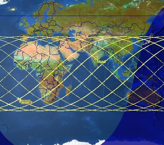
Incidentally, sivab ... we have decided to ignore the ghost stories so silence is golden.
Now that there is more clarity on the orbital data of RISAT-2 a realistic view has been created.
Incidentally, sivab ... we have decided to ignore the ghost stories so silence is golden.
Re: Indian Space Program Discussion
Question to Gurulog: Per the coverage shown by SSSalvi the northern end just about covers the areas of interest - any reason why we would not have tried to center it more? Is the coverage uniform across the areas mentioned?
-
Bade
- BRF Oldie
- Posts: 7212
- Joined: 23 May 2002 11:31
- Location: badenberg in US administered part of America
Re: Indian Space Program Discussion
Just move the orbital overlays more north as you suggest, and you will get the answer. The number of orbits passing over the regions of interest will decrease for any given day.Najunamar wrote:Question to Gurulog: Per the coverage shown by SSSalvi the northern end just about covers the areas of interest - any reason why we would not have tried to center it more? Is the coverage uniform across the areas mentioned?
Besides, the band covered by this orbital choice is the famous "360 by half degree azimuth of interest" for India.... both weather wise and security wise.
Re: Indian Space Program Discussion
Thanks! That would explain the traverse almost parallel to the border on the eastern side where Lizard needs to be watched plus the crossing on BD turf. Nice to know friendly eyes are up there to help prevent unlawful entry.
Re: Indian Space Program Discussion
It is an orbital data NOT coverage. Lizard's head and tail are both being watched.Najunamar wrote:Question to Gurulog: Per the coverage shown by SSSalvi the northern end just about covers the areas of interest - any reason why we would not have tried to center it more? Is the coverage uniform across the areas mentioned?
Re: Indian Space Program Discussion
The picture shows a few orbits only.Najunamar wrote:Question to Gurulog: Per the coverage shown by SSSalvi the northern end just about covers the areas of interest - any reason why we would not have tried to center it more? Is the coverage uniform across the areas mentioned?
Actually the satellite will cover all the area in-between the paths seen here also.
My feeling is that the 41 deg inclination is not specifically for Indian requirements. It may be so so that the already developed hard/softwares of the original parentage of this satellite can be used without much changes.
-
Bade
- BRF Oldie
- Posts: 7212
- Joined: 23 May 2002 11:31
- Location: badenberg in US administered part of America
Re: Indian Space Program Discussion
But, for a given day only so many orbits will cover the mid region of the orbital band. For targets closer to the edge of this band however, more orbits will overlay for any given day.SSSalvi wrote: The picture shows a few orbits only.
Actually the satellite will cover all the area in-between the paths seen here also.
The revisit periods with this orbital choice for Pakistan is shorter when compared to a spot in the middle of the Indian Ocean region.
For truly polar orbits it is easier to visualize ... since the polar regions get covered by every orbit (usually 14 orbits per day) whereas Pindi will get covered by one or two orbits at most per day depending on the swath width. That is the analogy I have in mind.
With the RISAT's orbital choice, Pindi is under constant watch so to speak...on a daily basis and even more frequently.
-
Prem Kumar
- BRF Oldie
- Posts: 4749
- Joined: 31 Mar 2009 00:10
Re: Indian Space Program Discussion
Something interesting I noticed when looking up the specs of TES (the experimental spy satellite that ISRO launched in 2001). It had a panchromatic camera (with the 1m resolution) and an X band antenna.
What was it - a radar satellite and an optical satellite rolled into one? Very intriguing ....
What was it - a radar satellite and an optical satellite rolled into one? Very intriguing ....
Re: Indian Space Program Discussion
That is data transmission antenna not RADAR. Data for all imaging satellites is transmitted in X Band.Prem Kumar wrote:Something interesting I noticed when looking up the specs of TES (the experimental spy satellite that ISRO launched in 2001). It had a panchromatic camera (with the 1m resolution) and an X band antenna.
What was it - a radar satellite and an optical satellite rolled into one? Very intriguing ....
Re: Indian Space Program Discussion
Incidentally IIRC that is a very interesting shaped (spiked) antenna. I would suspect not only wide angle/coverage but also programmable beam forming/nulling to ensure data radiated to 'pavitram' bearings onleeee.SSSalvi wrote:That is data transmission antenna not RADAR. Data for all imaging satellites is transmitted in X Band.Prem Kumar wrote:Something interesting I noticed when looking up the specs of TES (the experimental spy satellite that ISRO launched in 2001). It had a panchromatic camera (with the 1m resolution) and an X band antenna.
What was it - a radar satellite and an optical satellite rolled into one? Very intriguing ....
-
Prem Kumar
- BRF Oldie
- Posts: 4749
- Joined: 31 Mar 2009 00:10
Re: Indian Space Program Discussion
S^3 - thanks for the clarification.
On a related note, is it true that the CartoSat 2's performance has not been satisfactory, as mentioned in some news reports? Or is it plain old-fashioned DDM?
On a related note, is it true that the CartoSat 2's performance has not been satisfactory, as mentioned in some news reports? Or is it plain old-fashioned DDM?
Re: Indian Space Program Discussion
It has a narrow beam which is pointed continuously to the intended station only.Arun_S wrote:
Incidentally IIRC that is a very interesting shaped (spiked) antenna. I would suspect not only wide angle/coverage but also programmable beam forming/nulling to ensure data radiated to 'pavitram' bearings onleeee.